")
0.34 Miles
3.77 - 4.11
Cool-Cold Headwater
Poor
Low DO, Degraded Habitat
Total Phosphorus, Sediment/Total Suspended Solids
Jackson
Yes
No
Yes
Fish and Aquatic Life
Overview
Trump Coulee Creek is an 8 mile tributary to the Trempealeau River at Blair. It is managed as a forage fishery. A 1992 fish survey documented 11 forage and minnow species. The stream islimited by elevated water temperatures, organic loading, sedimentation and lack of suitale cover for trout. The dissolved oxygen level in the stream dropped below the state standard of 5.0 mg/l during a 1.13 inch rain in the fall of 1992. Instream cover is scarce and grazing of the streambanks contributes sediment to the stream bottom. This stream is capable of reaching Class III in Jackson County and Class II in Trempealeau County with minimzation of nonpoint source impacts (Schreiber).
Date 2005
Author Aquatic Biologist
General Condition
Although Trump Coulee Creek is listed for both sedimentation and dissolved oxygen impairments, this TMDL is limited to the sediment aspects. WDNR staff believe the control of manure in runoff from a single animal feeding operation was the cause of the dissolved oxygen problem. When monitoring results are available, WDNR intends to pursue delisting of the dissolved oxygen impairment.
The extensive coverage of the substrate with silt and soft organic sediment limits the areas of exposed gravel necessary for reproduction. It also greatly reduces the primary food sources that depend on clean interstitial areas. The relative smoothness of the substrate also minimizes areas for smaller forage fish to get out of faster currents.
Sediment has been identified as the pollutant causing these impairments. As such, the extensive coverage of the substrate with sediment constitutes an objectionable deposit under the narrative water quality standards criterion in s. NR 102.04(1)(a) cited below in the Water Quality Standards section.
Date 2004
Author Aquatic Biologist
Impaired Waters
Trump Coulee Creek for its entire length is not currently meeting applicable narrative water quality criterion as defined in NR 102.04 (1); Wis. Adm. Code: To preserve and enhance the quality of waters, standards are established to govern water management decisions. Practices attributable to municipal, industrial, commercial, domestic, agricultural, land development or other activities shall be controlled so that all waters including the mixing zone and effluent channel meet the following conditions at all times and under all flow conditions: (a) Substances that will cause objectionable deposits on the shore or in the bed of a water, shall not be present in such amounts as to interfere with public rights in waters of the state.
http://dnr.wi.gov/org/water/wm/wqs/303d/ApprovedTMDLs/Trump_Coulee_Final_Draft_TMDL.pdf
Date 2005
Author Jean Unmuth
Condition
Wisconsin has over 84,000 miles of streams, 15,000 lakes and milllions of acres of wetlands. Assessing the condition of this vast amount of water is challenging. The state's water monitoring program uses a media-based, cross-program approach to analyze water condition. An updated monitoring strategy (2015-2020) is now available. Compliance with Clean Water Act fishable, swimmable standards are located in the Executive Summary of Water Condition in 2018. See also the 'monitoring and projects' tab.
Reports
Recommendations
TMDL (USEPA) Approved
TMDL for Sediment Impaired Streams in the Waumandee Creek Watershed - Trump Coulee Creek. This TMDL project is designed to restore water resource substrate, which In most cases, the gravel substrate is extensively covered by sand, silt, and soft organic matter
preventing a suitable habitat for fish and macroinvertebrate communities. Filling-in of pools reduces the amount of available cover for juvenile and adult fish. Sedimentation of riffle areas reduces the reproductive success of fish by reducing the exposed gravel substrate necessary for
appropriate spawning conditions. Sedimentation also affects macroinvertebrate biomass (fish food source) which tends to be lower in areas with predominantly sand substrate than a stream substrate with a mix of gravel, rubble, and sand.
Management Goals
Wisconsin's Water Quality Standards provide qualitative and quantitative goals for waters that are protective of Fishable, Swimmable conditions [Learn more]. Waters that do not meet water quality standards are considered impaired and restoration actions are planned and carried out until the water is once again fishable and swimmable
Management goals can include creation or implementation of a Total Maximum Daily Load analysis, a Nine Key Element Plan, or other restoration work, education and outreach and more. If specific recommendations exist for this water, they will be displayed below online.
Monitoring
Monitoring the condition of a river, stream, or lake includes gathering physical, chemical, biological, and habitat data. Comprehensive studies often gather all these parameters in great detail, while lighter assessment events will involve sampling physical, chemical and biological data such as macroinvertebrates. Aquatic macroinvertebrates and fish communities integrate watershed or catchment condition, providing great insight into overall ecosystem health. Chemical and habitat parameters tell researchers more about human induced problems including contaminated runoff, point source dischargers, or habitat issues that foster or limit the potential of aquatic communities to thrive in a given area. Wisconsin's Water Monitoring Strategy was recenty updated.
Grants and Management Projects
Monitoring Projects
| WBIC | Official Waterbody Name | Station ID | Station Name | Earliest Fieldwork Date | Latest Fieldwork Date | View Station | View Data |
|---|
|
|
Watershed Characteristics
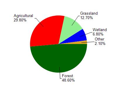
Trump Coulee Creek is located in the Upper Trempealeau River watershed which is 175.54 mi². Land use in the watershed is primarily forest (48.60%), agricultural (29.80%) and a mix of grassland (12.70%) and other uses (8.90%). This watershed has 359.69 stream miles, 209.54 lake acres and 7,549.82 wetland acres.
Nonpoint Source Characteristics
This watershed is ranked Not Available for runoff impacts on streams, Not Available for runoff impacts on lakes and High for runoff impacts on groundwater and therefore has an overall rank of High. This value can be used in ranking the watershed or individual waterbodies for grant funding under state and county programs.This water is ranked High Stream for individual Rivers based on runoff problems and the likelihood of success from project implementation.
Trump Coulee Creek is considered a Cool-Cold Headwater under the state's Natural Community Determinations.
Natural communities (stream and lake natural communities) represent model results and DNR staff valiation processes that confirm or update predicted conditions based on flow and temperature modeling from historic and current landscape features and related variables. Predicated flow and temperatures for waters are associated predicated fish assemblages (communities). Biologists evaluate the model results against current survey data to determine if the modeled results are corect and whether biological indicators show water quaity degradation. This analysis is a core component of the state's resource management framework. Wisconsin's Riverine Natural Communities.
Cool (Cold-Transition) Headwaters are small, usually perennial streams with cold to cool summer temperatures. Coldwater fishes are common to uncommon (<10 per 100 m), transitional fishes are abundant to common, and warm water fishes are uncommon to absent. Headwater species are abundant to common, mainstem species are common to absent, and river species are absent.
Trump Coulee Creek is located in one of 16 subwatersheds that make up the Upper Trempealeau River Watershed. Trump Coulee Creek is 8.0 miles in length with a 15.7 square mile watershed. The headwaters are in Jackson County with the downstream segments in Trempealeau County. The stream is currently supporting a warm water forage fishery. However, according to assessments conducted by WDNR water biologists, it has the potential to support a Class II cold water fishery in the upper 2.0 miles and a Class III cold water fishery in the lower 6.0 miles. The stream substrate is redominately shifting sand and silt with little or no gravel exposed in the riffle areas. Instream cover is generally scarce throughout the stream length. Stream banks are trampled by cattle, leaving little overhanging vegetation. As with other coulee streams, loose sediment covers a sandy, unstable substrate. As a result, much of the length of the stream is wide and shallow, not the narrow and deep cross-section characteristic of a healthy cold water stream in the driftless area of the state. The sediment load is also elevating water temperatures, but not to the level to call it an impairment.
Date 2011
Author Jean Unmuth