Walworth
No
No
No
Fish and Aquatic Life
Overview
Honey Lake, in the Sugar and Honey Creeks Watershed, is a 40.01 acre lake that falls in Walworth County. This lake is managed for fishing and swimming and is currently not considered impaired.
Date 2011
Author Aquatic Biologist
Historical Description
Source: 1961, Surface Water Resources of Walworth County,WI: WI-DNR Honey Lake (Vienna Lake), T-3-N, R-18-E, Surface Acres = 42, S.D.F. = 1.54, Maximum Depth = 9 feet.
An impoundment managed for northern pike, panfish, and largemouth, with bullheads common to the catch and carp abundant. This is a flowage of Sugar Creek created by a 10 foot high dam just above the junction of Sugar Creek with Honey Creek. Honey Creek is diverted along the east shore of the lake and does not contribute to its water supply. Culverts from the lake supply two smaller ponds in Racine County, Delmonte and Tahoe. Major use problems are carp and shallow mud flats at the delta of Sugar Creek. Boating is controlled by a local agreement limiting speed to 6 mph. A community beach serves the lake communities of all three small ponds, and access is available for fishing boats at one road end, and from several bridges. There are no liveries. Over 100 acres of fresh meadow indirectly border the lake southward.
Date 1961
Author Surface Water Inventory Of Wisconsin
Condition
Wisconsin has over 84,000 miles of streams, 15,000 lakes and milllions of acres of wetlands. Assessing the condition of this vast amount of water is challenging. The state's water monitoring program uses a media-based, cross-program approach to analyze water condition. An updated monitoring strategy (2015-2020) is now available. Compliance with Clean Water Act fishable, swimmable standards are located in the Executive Summary of Water Condition in 2018. See also the 'monitoring and projects' tab.
Reports
Recommendations
Habitat Restoration - Shoreland
Walworth County will continue the Walworth County Lakes Specialist position for one year. The Lakes Specialist will provide educational information to lake residents regarding shoreline stabilization and shoreline restoration. The Lakes Specialist will also design shoreline restoration projects for interested landowners, provide technical assistance to contractors and hold workshops on shoreland restoration.
Protect Riparian or Shorelands
Walworth County will implement the Shoreland Protection Initiative project that includes: 1. A baseline lakeshore inventory; 2. ten lakshore demonstration sites; 3. the preparation of lake lawn and yard nutrient management plans; 4. fact sheets on lakeshore stabilization, shoreland buffers, shoreland regulations and lawn care; 5. an annual lakeshore inventory and distribution of shoreland regulation materials; 6. formation of a Walworth Co. Lakes Association and meetings with and newsletter pertaining to Walworth Co. lakes; 7. Workshops, information packets and news articles pertaining to the Fox river Basin Partnership Team Lakes Initiative; and 8. the formation of the Walworth County Land Conservancy.
Land Acquisition
Walworth County will acquire approximately 123 acres of land to preserve and enhance the water quality of the downstream lake, Honey Lake. The goals of the property's management plan are to permanently preserve and protect the diversity and uniqueness of the existing land covering the Sugar Creek floodlands and shorelines, various wetland plan communities, uplands, and open field grasslands and to provide passive recreational opportunities such as hiking, natura study, and cross country skiing.
Management Goals
Wisconsin's Water Quality Standards provide qualitative and quantitative goals for waters that are protective of Fishable, Swimmable conditions [Learn more]. Waters that do not meet water quality standards are considered impaired and restoration actions are planned and carried out until the water is once again fishable and swimmable
Management goals can include creation or implementation of a Total Maximum Daily Load analysis, a Nine Key Element Plan, or other restoration work, education and outreach and more. If specific recommendations exist for this water, they will be displayed below online.
Monitoring
Monitoring the condition of a river, stream, or lake includes gathering physical, chemical, biological, and habitat data. Comprehensive studies often gather all these parameters in great detail, while lighter assessment events will involve sampling physical, chemical and biological data such as macroinvertebrates. Aquatic macroinvertebrates and fish communities integrate watershed or catchment condition, providing great insight into overall ecosystem health. Chemical and habitat parameters tell researchers more about human induced problems including contaminated runoff, point source dischargers, or habitat issues that foster or limit the potential of aquatic communities to thrive in a given area. Wisconsin's Water Monitoring Strategy was recenty updated.
Grants and Management Projects
Monitoring Projects
| WBIC | Official Waterbody Name | Station ID | Station Name | Earliest Fieldwork Date | Latest Fieldwork Date | View Station | View Data |
|---|
| 752300 | Honey Lake (Vienna) | 10006663 | Honey Lake | 6/1/1997 | 10/25/2023 | Map | Data |
| 752300 | Honey Lake (Vienna) | 653289 | Honey Lake - Deep Hole | 7/24/1978 | 5/5/2024 | Map | Data |
| 752300 | Honey Lake (Vienna) | 10014946 | Honey Lake_General Lake Station | | | Map | Data |
|
Watershed Characteristics
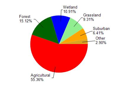
Honey Lake (Vienna) is located in the Sugar and Honey Creeks watershed which is 166.22 mi². Land use in the watershed is primarily agricultural (55.30%), forest (15.10%) and a mix of wetland (10.90%) and other uses (18.60%). This watershed has 208.62 stream miles, 1,943.12 lake acres and 9,489.18 wetland acres.
Nonpoint Source Characteristics
This watershed is ranked High for runoff impacts on streams, Medium for runoff impacts on lakes and High for runoff impacts on groundwater and therefore has an overall rank of High. This value can be used in ranking the watershed or individual waterbodies for grant funding under state and county programs.However, all waters are affected by diffuse pollutant sources regardless of initial water quality. Applications for specific runoff projects under state or county grant programs may be pursued. For more information, go to surface water program grants.