Oconto
No
No
No
Fish and Aquatic Life
Overview
This is a heavily polluted stream recommended for classification as a limited forage fishery, even though it currently contains limited aquatic life due to severe pollution. It drains a large wetland area just west of the Murphy Oil refinery in the city of Superior. Murphy Oil discharges to Newton Creek at T49N R14W S25 SWSE. This streams flows north through a city park before emptying into a wetland and shallow water area, Hog Island Inlet, which empties into Superior Bay in the Duluth-Superior Harbor. While the headwater wetlands contribute to the stream's baseflow, the majority of the stream's flow arises in the refinery's lagoons. Fish and other higher aquatic life forms are unable to survive in this stream. Bioassays have shown that Newton Creek water and the area around the creek mouth at Hog Island Inlet demonstrate acute and chronic toxicity in test organisms. Present are petroleum byproducts, metals and other substances. Water quality data collected by WDNR indicated that some reaches of the stream have levels of dissolved oxygen below the 5 milligram per liter necessary for growth and activity of fish, at times ranging below levels that would stress most aquatic organisms. Phosphorus concentrations range as high as 300 parts per billion. Levels of more than 30 ppb are thought to increase plant growth. Total phosphorus levels in Hog Island Inlet were measured with values that would indicate eutrophic waters, higher than 100 ppb in several samples.
In 1993 and 1994, WDNR conducted a characterization study of contamination in the sediments of the Newton Creek system, which encompasses the 1.5-acre impoundment at its headwaters, the stream and flood plain and 15-acre Hog Island Inlet of Superior Bay. Study of the system prior to 1993 indicated contaminants at levels harmful to aquatic life and raised concerns that contamination from Newton Creek reaches Superior Bay and Lake Superior. The characterization study has concluded that ecological impacts in most reaches of Newton Creek Impoundment and the creek are severe, based on observed impairment to the aquatic community, measured toxicity and high concentrations of diesel range organics and lead. Severe ecological impacts also appear to occur in the sediment community of the western and central portions of Hog Island Inlet. Sediment analysis turned up varying levels of toxicity throughout the inlet. The wetland isthmus between Hog Island Inlet and Superior Bay showed significant impairment to the sediment-dwelling community. The study concluded the wetland area may be suffering some ill effects from Newton Creek contamination, but not at severe levels. In Superior Bay, significant, but not severe sediment toxicity was observed at one station, but no effects at another. There did not appear to be any observed effect on the sediment-dwelling aquatic community.
The study recommends three portions of the Newton Creek System be considered for remediation: The entire area of the impoundment including about 1,600 cubic yards of soft sediments. The entire length of the creek from 21st Street to 6th Street, except for one upstream reach, and the length from U.S. Highway 2-53 to Hog Island Inlet. The volume of stream sediments and floodplain soils that should be considered for remediation in this stretch include 2,300 cubic yards of material along 5,600 linear feet of stream.
The western one-third of Hog Island Inlet, comprising 34,200 square yards and representing an estimated sediment volume of 16,000 cubic yards. Pollutants of concern in the Newton Creek System include hydrocarbons, metals and ammonia. Diesel range organics concentrations exceed 10,000 micrograms per gram at several locations in the impoundment, with the creek and inlet exhibiting lower, but still high maximum concentrations. Maximum background concentrations in reference creeks and inlets in the area ranged between 13 and 340 micrograms per gram.
Date 2010
Author Aquatic Biologist
Condition
Wisconsin has over 84,000 miles of streams, 15,000 lakes and milllions of acres of wetlands. Assessing the condition of this vast amount of water is challenging. The state's water monitoring program uses a media-based, cross-program approach to analyze water condition. An updated monitoring strategy (2015-2020) is now available. Compliance with Clean Water Act fishable, swimmable standards are located in the Executive Summary of Water Condition in 2018. See also the 'monitoring and projects' tab.
Management Goals
Wisconsin's Water Quality Standards provide qualitative and quantitative goals for waters that are protective of Fishable, Swimmable conditions [Learn more]. Waters that do not meet water quality standards are considered impaired and restoration actions are planned and carried out until the water is once again fishable and swimmable
Management goals can include creation or implementation of a Total Maximum Daily Load analysis, a Nine Key Element Plan, or other restoration work, education and outreach and more. If specific recommendations exist for this water, they will be displayed below online.
Monitoring
Monitoring the condition of a river, stream, or lake includes gathering physical, chemical, biological, and habitat data. Comprehensive studies often gather all these parameters in great detail, while lighter assessment events will involve sampling physical, chemical and biological data such as macroinvertebrates. Aquatic macroinvertebrates and fish communities integrate watershed or catchment condition, providing great insight into overall ecosystem health. Chemical and habitat parameters tell researchers more about human induced problems including contaminated runoff, point source dischargers, or habitat issues that foster or limit the potential of aquatic communities to thrive in a given area. Wisconsin's Water Monitoring Strategy was recenty updated.
Grants and Management Projects
| Project Name (Click for Details) | Year Started |
|---|
|
|
Monitoring Projects
| WBIC | Official Waterbody Name | Station ID | Station Name | Earliest Fieldwork Date | Latest Fieldwork Date | View Station | View Data |
|---|
|
|
Watershed Characteristics
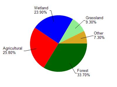
Newton Creek is located in the Lower Oconto River watershed which is 196.48 mi². Land use in the watershed is primarily forest (33.70%), agricultural (25.80%) and a mix of wetland (23.90%) and other uses (16.60%). This watershed has 314.34 stream miles, 3,972.16 lake acres and 24,684.40 wetland acres.
Nonpoint Source Characteristics
This watershed is ranked Low for runoff impacts on streams, Not Ranked for runoff impacts on lakes and High for runoff impacts on groundwater and therefore has an overall rank of High. This value can be used in ranking the watershed or individual waterbodies for grant funding under state and county programs.However, all waters are affected by diffuse pollutant sources regardless of initial water quality. Applications for specific runoff projects under state or county grant programs may be pursued. For more information, go to surface water program grants.