Ozaukee
No
No
No
Fish and Aquatic Life
Overview
Haneman Lake, in the Milwaukee River South Watershed, is a 4.44 acre lake that falls in Ozaukee County. This lake is managed for fishing and swimming and is currently not considered impaired.
Date 2011
Author Aquatic Biologist
Historical Description
Hanneman Lake Subwatershed is located in western Ozaukee County in the upper part of the
Milwaukee River South Watershed. Surface waters include one perennial stream, two small
perennial freshets, two natural lakes, Hanneman Lake, Drzewicki Lake, and a number of
culturally-derived ponds.
Water Resowws - The largest perennial stream in this subwatershed, hereafter referred to by
its local name, Mole Creek, is roughly 7.1 miles long, drains approldmately 8.5 square miles, and
discharges to the Milwaukee River in the village of Grafton. This cold water stream has
adequate flow to sustain viable populations of sport fish and other aquatic life. Extensive
wetlands are located along the stream particutarly in the upper three-fourths of the
subwatershed. However, portions of the stream and wetlands have been channelized to
accommodate agricultural and urban uses. The entire stream course is contained in "primary
environmental corridor". The dominant substrate is cobble and gravel although deposition of
fine, organic-laden sediment occurs in the upper one-third of the stream reach. Embeddedness
as a measure of deposition averages between 5-75 percent with higher values downstream of the
pond and residential construction sites. Mole Creek contains the most unique and diverse
forage frsh community of any Milwaukee River tributary in the Milwaukee River South Branch
Watershed. Species intolerant of poor water quality and degraded habitat, such as the mottled
sculpin, are present in Mole Creek and are also present in many trout streams throughout the
state of Wismnsin.
Habitat and water quality in Mole Creek are generally " but meet only part of the stream's
full biological and recreational potential. Limiting facto ude loss of fish and invertebrate
habitat; potentially elevated water temperatures; r water and habitat quality from upland and
construction site erosion; uhan stormwater runofe channelimtion; livestock acmss to streams
and stream banks; unpermitted pond construction adjacent to wetlands and springs; and
potentially toxic groundwater discharges from an abandoned coal fly ash landfill. Proliferation
of unpermitted pond construction has significant impact on all streams in this subwatershed.
Interception of spring freshets diverts cold water from Mole Creek and the small perennials and
excavation materials from pond construction have been dumped in nearby wetlands. Provided
these limiting factors are abated, Mole Creek may provide suitable water quality and habitat to
support trout populations. Mole Creek deserves special protection as the least darter, currently
contained in the State Watch Fish species List, is resident to the stream.
Date 1992
Author Surface Water Inventory Of Wisconsin
Historical Description
Parks - No county, state, or community-owned recreational sites are located in this
subwatershed. One private golf club, the Edgewater, is located in the town of Grafton along an
intermittent stream tributary to the Milwaukee River. SEWRPC has also identified five miles
of environmental corridor lands along the main stem of the river.
- The major timber types are Northern Hardwood and Swamp Hardwood. The
majority of the productive (in regards to forestry) woodlots are being utilized for homesites and
much of the Swamp hardwood is dying because of fluctuating water tables.
There are three tax law entries totaling 68 acres. Because of pressure from urbanization there
is no Conservation Reserve Program (CRP) enrollment. Tree planting occurs but is scattered
and limited, with wildlife plantings and windbreaks the most prevalent planting reasons. Logging
activity is insignificant.
The area is becoming heavily urbanized. Because of the accelerated urbanization rate, careful
planning is needed to protect sensitive wooded areas and thus minimize run-off from
construction sites into surface waters.
rdsm Waste - This subwatershed has three abandoned landfills: town of
Grafton, city/town of Cedarburg and the Wisconsin Electric Power Company. While there are
no active landfills within this drainage system, residents have access to privately-owned landfills
in neighboring areas. Long-range solid waste management planning will assist in developing
safeguard measures for surface and groundwater resources in the Hanneman Lake subwatershed.
The city and town of Cedarburg both provide volunteer recycling opportunities.
- There are no municipal or community water systems in this subwatershed.
Private wells supply the water needs of residents in this drainage system.
- Regular program activities ur on a case-by-case basis and
are in response to actions or requests from individuals. These activities include protection of
wetlands through regulation and review of county wetlandlshoreland ordinances and
incorporation of watershed objectives into projects requiring water regulation permits.
Additional program responsibilities include review of and response to the Federal Clean Water
Act, Section 404 applications to fill small wetlands. Special evaluation of water regulation or
zoning projects affecting Mole Creek and its potential cold water fishing is needed.
Wastaemter - The Ozaukee County Sanitarian is responsible for on-site wastewater
management in this subwatershed as there are no municipal wastewater treatment plants located
in the subwatershed,
- Rural upland erosion contributes 72 percent of the sediment load, which
sively from croplands. Rural stream bank erosion contributes 24 percent.
Overall, urban lands do not contribute a large percent of the subwatershed sediment load, but
may be causing localized impacts relating primarily to water temperature. It is anticipated that
the urban area in the subwatershed will nearly triple, because of urbanization in the towns of
Cedarburg, Saukville, Grafton, and the villages of Saukville and Grafton. The village of
Sauhille and the tom of Cedarburg have adopted the state model construction erosion control
ordinance and the village of Grafton has li dinance provisions. The other municipalities
have no ordinance coverage. Mole Creek an estimated annual lead load of 63 pounds
in addition to other urban toxicants. There are 11 barnyards in the subwatershed that drain to
Mole Creek or its tributaries.
Date 1992
Author Surface Water Inventory Of Wisconsin
Historical Description
Information concerning the other three small perennial stream frahets is limited, and because
of this lack of information, use classifications should be considered preliminary. Stream A,
located at TlON R21E, Sec.15 SE of SW quarter, contributes l water to Mole Creek via
spring flow and has wooded corridor along its lower reaches. am B, TlON R21E, Sec.2, SE
quarter, observed to have relatively low but cool Bow during the summer drought of 1988,
normally has shallow water depth. Wetland corridor along the lower reaches d
wildlife habitat. Stream C, TlON R20E, Sec.5 SE of quarter, has instream habitat similar
to stream B but a greater percentage of the surrounding wetlands are being converted to
residential use. Past channelization has limited instream habitat quality in all three streams.
Hanneman Lake is a small (6.0 acre) hardwater seepage lake with a maximum depth of 18.0
feet. There is no public access. Drzewicki Lake is a small (1.6 acre) lake with no public
a ~ e s s . A shallow manh eaends southemt &om Drze~cki h k e to Hanneman Lake.
Because of the shallow depths and small size, Mole Creek and the smaller perennial streams are
classified as supporting "partial-body contactw forms of recreational use.
Fkhefies - Hanneman Lake, Drzewicki Lake, Mole Creek and numerous private ponds
constitute the prima9 surface waters of this subwatershed, only Mole Creek is accessible to the
general public. The latter, however, stream does not currently support a recreational fishery.
The presence of mottled sculpins does suggest that this stream enjoys excellent water quality
and may support a limited fishery with adequate habitat and protection. Extensive ditching of
the headwaters, private pond development and residential encroachment threaten the long term
health and fisheries potential of this locally unique resource. Despite its size, the maintenance
of water quality and quantity in this tributary and all others is also critical to maintaining viable
habitat and sport fisheries of the mainstem Milwaukee River. A variety of warmwater species
utilizing the lower reaches of Mole Creek include r o d bass, pumpkinseed and several species of
darters.
Wildlife - Riparian wildlife habitat consists of 45 percent forested and 16 percent wetland cover
types. Nearly 39 percent of the riparian areas are cropped, 58 acres of which are eligible for
entry into CRP as vegetative filter strips. Farmed wetlands and highly erodible farmland may be
eligible for entry into CRP. Restorable wetlands also exist as this subwatershed borders
Cedarburg Bog. Restorable wetlands will increase waterfowl broodinfleeding and resting areas,
thus enhancing the attractiveness of Mud and Long Lakes located in the Cedar Creek
watershed.
Date 1992
Author Surface Water Inventory Of Wisconsin
Historical Description
Source: 1963 Surface Water Resources of Ozaukee County Hanneman Lake T10N, R21E, Section 3 Surface Acres = 6.0, S.D.F. = 1.43, Maximum Depth = 18 feet.
A small, landlocked seepage-fed lake, in the ground moraine of the Lake Michigan Glacier. Largemouth bass and panfish are the main species. Stunted panfish and winterkill are two of the management problems. One cabin overlooks the lake. No public access or hunting is allowed. The eastern end of this lake has a small woody marsh which may provide cover for nesting waterfowl. Migrating ducks do not make extensive use of this lake. Hansen Lake T11N, R21E, Section 4 Surface Acres = 6.0, S.D.F. = 1.02, Maximum Depth = 9 feet A small, landlocked seepage lake. Due to its shallowness, winterkill is a problem and sport fishery value is negligible. Waterfowl nesting is the primary value of this lake. Some use is made by migrating puddlers. Public access is not available but hunting is permitted. The shoreline is wooded and adds greatly to its aesthetic value.
Date 1963
Author Surface Water Inventory Of Wisconsin
Condition
Wisconsin has over 84,000 miles of streams, 15,000 lakes and milllions of acres of wetlands. Assessing the condition of this vast amount of water is challenging. The state's water monitoring program uses a media-based, cross-program approach to analyze water condition. An updated monitoring strategy (2015-2020) is now available. Compliance with Clean Water Act fishable, swimmable standards are located in the Executive Summary of Water Condition in 2018. See also the 'monitoring and projects' tab.
Reports
Management Goals
Wisconsin's Water Quality Standards provide qualitative and quantitative goals for waters that are protective of Fishable, Swimmable conditions [Learn more]. Waters that do not meet water quality standards are considered impaired and restoration actions are planned and carried out until the water is once again fishable and swimmable
Management goals can include creation or implementation of a Total Maximum Daily Load analysis, a Nine Key Element Plan, or other restoration work, education and outreach and more. If specific recommendations exist for this water, they will be displayed below online.
Monitoring
Monitoring the condition of a river, stream, or lake includes gathering physical, chemical, biological, and habitat data. Comprehensive studies often gather all these parameters in great detail, while lighter assessment events will involve sampling physical, chemical and biological data such as macroinvertebrates. Aquatic macroinvertebrates and fish communities integrate watershed or catchment condition, providing great insight into overall ecosystem health. Chemical and habitat parameters tell researchers more about human induced problems including contaminated runoff, point source dischargers, or habitat issues that foster or limit the potential of aquatic communities to thrive in a given area. Wisconsin's Water Monitoring Strategy was recenty updated.
Grants and Management Projects
Monitoring Projects
| WBIC | Official Waterbody Name | Station ID | Station Name | Earliest Fieldwork Date | Latest Fieldwork Date | View Station | View Data |
|---|
| 26400 | Haneman Lake | 101075 | Haneman Lake | 8/28/2008 | 7/29/2011 | Map | Data |
|
Watershed Characteristics
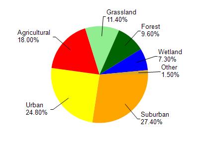
Haneman Lake is located in the Milwaukee River South watershed which is 167.90 mi². Land use in the watershed is primarily suburban (27.40%), urban (24.80%) and a mix of agricultural (18%) and other uses (29.80%). This watershed has 203.63 stream miles, 13,038.94 lake acres and 5,996.03 wetland acres.
Nonpoint Source Characteristics
This watershed is ranked High for runoff impacts on streams, High for runoff impacts on lakes and High for runoff impacts on groundwater and therefore has an overall rank of High. This value can be used in ranking the watershed or individual waterbodies for grant funding under state and county programs.However, all waters are affected by diffuse pollutant sources regardless of initial water quality. Applications for specific runoff projects under state or county grant programs may be pursued. For more information, go to surface water program grants.