Waukesha
No
No
No
Fish and Aquatic Life
Overview
This small drainage lake on the Oconomowoc River was enlarged to 78 acres by a 8-foot dam in the City of Oconomowoc. The water is clear and only about 15 percent of the basin is deeper than 20 feet. Overgrowth of rooted aquatic plants and algae have frequently necessitated control measures. The fishery is primarily largemouth bass and panfish. Walleyes are stocked and muskellunge have become established from upstream Okauchee Lake. Carp are common in this drainage system. Adequate public access is afforded by the city park boat launch, several city roads, and terraces.
The U.S. Geological Survey, in cooperation with the Fowler Lake Management District, completed a hydrologic and water-quality study of Fowler Lake in 1984. The report, Hydrology, Water Quality, Trophic Status and Aquatic Plants of Fowler Lake, Wisconsin, is available at WDNR Southeast District Headquarters.
In 1990, the Fowler Lake Management District received a Wisconsin Lake Management Planning Grant. The grant was used to hire the U.S. Geological Survey to monitor the water quality for six years (1991-1996). The report concluded that Fowler Lake is moderately fertile with excellent water clarity. The lake thermally stratifies during the summer with oxygen depletion occurring in the deepest part of the lake. The Oconomowoc River contributes 98 percent of the inflow and 88 percent of the phosphorus load to the lake. The annual phosphorus load was estimated to be 28 pounds per square mile. This is considered low and indicates the presence of upstream lakes that are filtering out available nutrients. The aquatic macrophyte community is dominated by Chara sp. (muskgrass), Myriophyllum sp. (native water milfoil), Najas marina and Vallisneria americana (wild celery).
Zebra mussel veligers have been identified in the watershed, upstream of Fowler Lake. No evidence of this exotic species currently exists in this lake.
Date 2002
Author Aquatic Biologist
Historical Description
Source: 1963, Surface Water Resources of Waukesha County Fowler Lake T8N, R17E, Section 33
A small drainage lake on the Oconomowoc River enlarged in area by an impounding structure of 8 feet in the City of Oconomowoc. The water is clear and only about 15 per cent of the basin is greater than 20 feet deep. Weeds and algae are use problems which have frequently necessitated control measures. The fishery is primarily for largemouth bass and pan fish. Carp are common in this drainage system. . Adequate public access is afforded by a city park, several city roads and terraces.
Surface Acres = 78, S.D.F. = 1.37, Maximum Depth = 50 feet
Date 1963
Author Surface Water Inventory Of Wisconsin
General Condition
Citizen lake monitoring in 2021 of Fowler Lake - Deep Hole involved sampled 20 different days during the 2021 season. Parameters sampled included: water clarity, temperature, total phosphorus, chlorophyll.
The average summer (July-Aug) secchi disk reading for Fowler Lake - Deep Hole (Waukesha County, WBIC: 849400) was 15.5 feet. The average for the Southeast Georegion was 7.1 feet. Typically the summer (July-Aug) water was reported as CLEAR and YELLOW.
Chemistry data collected on Fowler Lake - Deep Hole documented the average summer Chlorophyll in 2021 was 1.1 ug/l (compared to a Southeast Georegion summer average of 20.9 ug/l). The summer Total Phosphorus average was 13.7 ug/l. Lakes that have more than 20 ug/l and impoundments that have more than 30 ug/l of total phosphorus may experience noticeable algae blooms.
The overall Trophic State Index (based on chlorophyll) for Fowler Lake - Deep Hole was 36. The TSI suggests that Fowler Lake - Deep Hole was oligotrophic. This TSI suggests deeper lakes still oligotrophic, but bottom water of some shallower lakes will become oxygen-depleted during the summer. Oligotrophic lakes are characterized by a low accumulation of dissolved nutrient salts, supporting but a sparse growth of algae and other organisms, and having a high oxygen content owing to the low organic content. (Data from Wisconsin Citizen Monitoring Program)
Date 2022
Author Lisa Helmuth
General Condition
Fowler Lake (WBIC 849400) was assessed during the 2018 listing cycle; new total phosphorus and chlorophyll-a sample data were clearly below 2018 WisCALM listing thresholds for the Recreation use and the Fish and Aquatic Life use. This water was meeting these designated uses and was not considered impaired.
Date 2017
Author Ashley Beranek
Condition
Wisconsin has over 84,000 miles of streams, 15,000 lakes and milllions of acres of wetlands. Assessing the condition of this vast amount of water is challenging. The state's water monitoring program uses a media-based, cross-program approach to analyze water condition. An updated monitoring strategy (2015-2020) is now available. Compliance with Clean Water Act fishable, swimmable standards are located in the Executive Summary of Water Condition in 2018. See also the 'monitoring and projects' tab.
Reports
Management Goals
Wisconsin's Water Quality Standards provide qualitative and quantitative goals for waters that are protective of Fishable, Swimmable conditions [Learn more]. Waters that do not meet water quality standards are considered impaired and restoration actions are planned and carried out until the water is once again fishable and swimmable
Management goals can include creation or implementation of a Total Maximum Daily Load analysis, a Nine Key Element Plan, or other restoration work, education and outreach and more. If specific recommendations exist for this water, they will be displayed below online.
Monitoring
Monitoring the condition of a river, stream, or lake includes gathering physical, chemical, biological, and habitat data. Comprehensive studies often gather all these parameters in great detail, while lighter assessment events will involve sampling physical, chemical and biological data such as macroinvertebrates. Aquatic macroinvertebrates and fish communities integrate watershed or catchment condition, providing great insight into overall ecosystem health. Chemical and habitat parameters tell researchers more about human induced problems including contaminated runoff, point source dischargers, or habitat issues that foster or limit the potential of aquatic communities to thrive in a given area. Wisconsin's Water Monitoring Strategy was recenty updated.
Grants and Management Projects
Monitoring Projects
| WBIC | Official Waterbody Name | Station ID | Station Name | Earliest Fieldwork Date | Latest Fieldwork Date | View Station | View Data |
|---|
| 849400 | Fowler Lake | 683384 | Fowler Lake - Ajd Lf George Tr-3-D | 8/9/1996 | 8/9/1996 | Map | Data |
| 849400 | Fowler Lake | 683379 | Fowler Lake - Ajd Lf George Tr-1-D | 8/9/1996 | 8/9/1996 | Map | Data |
| 849400 | Fowler Lake | 683122 | Fowler Lake - Deep Hole | 9/18/1973 | 9/17/2025 | Map | Data |
| 849400 | Fowler Lake | 10007249 | Fowler Lake | 11/1/1994 | 3/13/2026 | Map | Data |
| 849400 | Fowler Lake | 683383 | Fowler Lake - Ajd Lf George Tr-2-S1 | | | Map | Data |
| 849400 | Fowler Lake | 683386 | Fowler Lake - Ajd Lf George Tr-4 D | | | Map | Data |
| 849400 | Fowler Lake | 10017557 | Fowler Lake -- Access | 9/1/2010 | 8/30/2025 | Map | Data |
| 849400 | Fowler Lake | 683385 | Fowler Lake - Ajd Lf George Tr-3-S | 8/9/1996 | 8/9/1996 | Map | Data |
| 849400 | Fowler Lake | 683381 | Fowler Lake - Ajd Lf George Tr-2-D | 8/9/1996 | 8/9/1996 | Map | Data |
| 849400 | Fowler Lake | 683380 | Fowler Lake - Ajd Lf George Tr-1-S | 8/9/1996 | 8/9/1996 | Map | Data |
| 849400 | Fowler Lake | 10050683 | Fowler Lake - Outlet at North Lake Road | 10/15/2020 | 12/18/2023 | Map | Data |
|
Watershed Characteristics
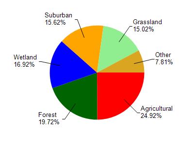
Fowler Lake is located in the Oconomowoc River watershed which is 130.86 mi². Land use in the watershed is primarily agricultural (24.90%), forest (19.70%) and a mix of wetland (16.90%) and other uses (38.40%). This watershed has 136.99 stream miles, 2,858.66 lake acres and 11,105.19 wetland acres.
Nonpoint Source Characteristics
This watershed is ranked Not Available for runoff impacts on streams, Not Available for runoff impacts on lakes and High for runoff impacts on groundwater and therefore has an overall rank of High. This value can be used in ranking the watershed or individual waterbodies for grant funding under state and county programs.However, all waters are affected by diffuse pollutant sources regardless of initial water quality. Applications for specific runoff projects under state or county grant programs may be pursued. For more information, go to surface water program grants.