Adams
No
No
No
Fish and Aquatic Life
Overview
Trout Creek - There is limited information available for this creek.
Ripp, Coreen, Koperski, Cindy and Folstad, Jason. 2002. The State of the Lower Wisconsin River Basin. PUBL WT-559-2002. Wisconsin Department of Natural Resources, Madison, WI.
Fawn Lake is a 19-acre impoundment on Trout Creek in southwest Adams County, Wisconsin. The dam for Fawn Lake was authorized in 1970-71. Complaints concerning heavy aquatic plant growth were recorded as early as 1974. Investigations at that time found heavy growth of sago pondweed and leafy pondweed. Some coontail was also found. The first recorded chemical treatments were in 1981. Between 1981 and 2002, several different chemicals were used to treat aquatic plants and algae (Table 1). Up to 10 acres had been treated in some years (more than half the lake) and multiple
treatments had been conducted many of the years.
Diquat and Aquathol are broad-spectrum chemicals that kill all
plant species. DNR Fish Management reported that chemical
treatments were removing nearly all the plant material in the
lake (1995, internal memo). Removing large portions of the
aquatic plant community left little habitat for fish, augmented
the algae problem and set up an ideal situation for the
introduction and colonization of the two exotic plant species in
Fawn Lake.
AV-70 and CuSO4 are copper products that were used to kill algae
(Table 1). The drawbacks of copper treatments are:
1) the very short effective time
2) the toxicity of copper to aquatic insects, an important part
of the food chain in a lake
3) the build up of copper in the sediments, resulting in
sediments that are toxic to mollusks that are the natural
consumers of algae in a lake.
Recently, 2,4-D chemicals have been used to selectively treat the
Eurasian water milfoil.
In 1999, Fawn Lake was drawn down for dam repair. The lake was
left down over the winter in an attempt to help control Eurasian
watermilfoil. Unfortunately, the spring of 2000 was dry and the
lake remained below normal level most of the summer.
In 2002, the residents on Fawn Lake formed a Lake District in
order to enable them to more effectively carry out programs to
improve Fawn Lake.
Date 2002
Author Cynthia Koperski
Historical Description
Trout Creek, T14N, R6E, Section 6, Surface Acres = 0.8, Miles = 1.5, Gradient = 28.6 feet per mile.
This is a clear, hard water, sand bottom stream. It flows in a westerly direction
into the Wisconsin River. Forage fish species comprise the fishery. A private
campground and pond are located near the headwaters and near the mouth there is a
commercial trout pond. During the February, 1963, aerial groundwater survey, open
water was observed the entire length of the stream. Access is possible from two road
crossings.
From: Klick, Thomas A. and C.W. Threinen. 1966. Surface Water Resources of Adams County:
Lake and Stream Classification Project. Wisconsin Conservation Department, Madison, WI.
Date 1966
Author Surface Water Inventory Of Wisconsin
Condition
Wisconsin has over 84,000 miles of streams, 15,000 lakes and milllions of acres of wetlands. Assessing the condition of this vast amount of water is challenging. The state's water monitoring program uses a media-based, cross-program approach to analyze water condition. An updated monitoring strategy (2015-2020) is now available. Compliance with Clean Water Act fishable, swimmable standards are located in the Executive Summary of Water Condition in 2018. See also the 'monitoring and projects' tab.
Reports
Management Goals
Wisconsin's Water Quality Standards provide qualitative and quantitative goals for waters that are protective of Fishable, Swimmable conditions [Learn more]. Waters that do not meet water quality standards are considered impaired and restoration actions are planned and carried out until the water is once again fishable and swimmable
Management goals can include creation or implementation of a Total Maximum Daily Load analysis, a Nine Key Element Plan, or other restoration work, education and outreach and more. If specific recommendations exist for this water, they will be displayed below online.
Monitoring
Monitoring the condition of a river, stream, or lake includes gathering physical, chemical, biological, and habitat data. Comprehensive studies often gather all these parameters in great detail, while lighter assessment events will involve sampling physical, chemical and biological data such as macroinvertebrates. Aquatic macroinvertebrates and fish communities integrate watershed or catchment condition, providing great insight into overall ecosystem health. Chemical and habitat parameters tell researchers more about human induced problems including contaminated runoff, point source dischargers, or habitat issues that foster or limit the potential of aquatic communities to thrive in a given area. Wisconsin's Water Monitoring Strategy was recenty updated.
Grants and Management Projects
Monitoring Projects
| WBIC | Official Waterbody Name | Station ID | Station Name | Earliest Fieldwork Date | Latest Fieldwork Date | View Station | View Data |
|---|
|
|
Watershed Characteristics
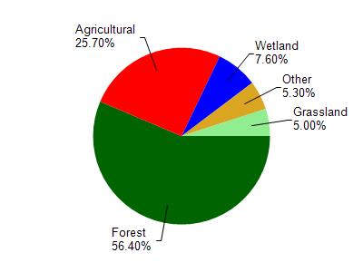
Trout Creek is located in the Duck and Plainville Creeks watershed which is 195.09 mi². Land use in the watershed is primarily forest (56.40%), agricultural (25.70%) and a mix of wetland (7.60%) and other uses (10.30%). This watershed has 218.59 stream miles, 339.26 lake acres and 9,551.62 wetland acres.
Nonpoint Source Characteristics
This watershed is ranked Low for runoff impacts on streams, Low for runoff impacts on lakes and High for runoff impacts on groundwater and therefore has an overall rank of High. This value can be used in ranking the watershed or individual waterbodies for grant funding under state and county programs.However, all waters are affected by diffuse pollutant sources regardless of initial water quality. Applications for specific runoff projects under state or county grant programs may be pursued. For more information, go to surface water program grants.