")
2.82 Miles
3.50 - 6.32
Macroinvertebrate, Cool-Cold Headwater, Coldwater
2018
Good
Juneau
Yes
No
No
Fish and Aquatic Life
Overview
Fountain Creek, located in western Juneau County, flows in a northerly direction through the
Village of Hustler for 3.5 miles before reaching the Little Lemonweir River. This stream has a
gradient of 11 feet per mile and is a Class II trout stream for its entire length.
Fountain Creek is one of the most popular and heavily fished trout streams in Juneau County.
The purchase of streambank easements has been an objective of WDNR Fisheries Biologists
for many years. Local trout anglers expressed an interest in improvement of trout habitat in
Fountain Creek, which is choked with tag alder, making it very difficult for anglers to fish.
Many windfalls throughout the WDNR easement area were also causing streambank erosion.
During the summer of 2001, three thousand eight hundred feet of in-stream trout habitat work
was completed on Fountain Creek. Habitat work best suited to Fountain Creek was to cut
brush along the stream and utilize it for brush bundles that were strategically placed
throughout the entire project area. Brush bundles narrow the width of the stream channel,
concentrating flow to a smaller area which in turn scours out unwanted sediments that
eventually expose trout spawning substrate. Other work included installation of eighteen
digger logs, which provide overhead cover for trout, and create pool areas; three log wing
deflectors, which force the flow of the water to more stable banks; and four overhead log
covers which provide cover for fish species. Many springs which feed Fountain Creek were
cleaned out by removing brush and grasses. A fish and habitat survey of the section which
recently received habitat improvements should be surveyed to determine existing conditions
and classification. Access to Fountain Creek is from WDNR easements and three road
crossings.
Ripp, Coreen, Koperski, Cindy and Folstad, Jason. 2002. The State of the Lower Wisconsin River Basin.
PUBL WT-559-2002. Wisconsin Department of Natural Resources, Madison, WI.
Date 2002
Author Cynthia Koperski
Condition
Wisconsin has over 84,000 miles of streams, 15,000 lakes and milllions of acres of wetlands. Assessing the condition of this vast amount of water is challenging. The state's water monitoring program uses a media-based, cross-program approach to analyze water condition. An updated monitoring strategy (2015-2020) is now available. Compliance with Clean Water Act fishable, swimmable standards are located in the Executive Summary of Water Condition in 2018. See also the 'monitoring and projects' tab.
Reports
Management Goals
Wisconsin's Water Quality Standards provide qualitative and quantitative goals for waters that are protective of Fishable, Swimmable conditions [Learn more]. Waters that do not meet water quality standards are considered impaired and restoration actions are planned and carried out until the water is once again fishable and swimmable
Management goals can include creation or implementation of a Total Maximum Daily Load analysis, a Nine Key Element Plan, or other restoration work, education and outreach and more. If specific recommendations exist for this water, they will be displayed below online.
Monitoring
Monitoring the condition of a river, stream, or lake includes gathering physical, chemical, biological, and habitat data. Comprehensive studies often gather all these parameters in great detail, while lighter assessment events will involve sampling physical, chemical and biological data such as macroinvertebrates. Aquatic macroinvertebrates and fish communities integrate watershed or catchment condition, providing great insight into overall ecosystem health. Chemical and habitat parameters tell researchers more about human induced problems including contaminated runoff, point source dischargers, or habitat issues that foster or limit the potential of aquatic communities to thrive in a given area. Wisconsin's Water Monitoring Strategy was recenty updated.
Grants and Management Projects
| Project Name (Click for Details) | Year Started |
|---|
|
|
Monitoring Projects
| WBIC | Official Waterbody Name | Station ID | Station Name | Earliest Fieldwork Date | Latest Fieldwork Date | View Station | View Data |
|---|
| 1306900 | Fountain Creek | 10051572 | Fountain Creek - Olsen Road | 5/19/2018 | 5/19/2018 | Map | Data |
|
Watershed Characteristics
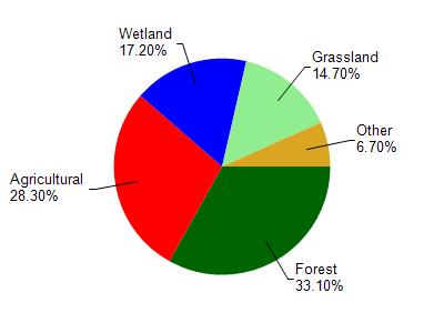
Fountain Creek is located in the Little Lemonweir River watershed which is 218.01 mi². Land use in the watershed is primarily forest (33.10%), agricultural (28.30%) and a mix of wetland (17.20%) and other uses (21.40%). This watershed has 488.22 stream miles, 1,656.86 lake acres and 18,277.64 wetland acres.
Nonpoint Source Characteristics
This watershed is ranked Not Ranked for runoff impacts on streams, Low for runoff impacts on lakes and High for runoff impacts on groundwater and therefore has an overall rank of High. This value can be used in ranking the watershed or individual waterbodies for grant funding under state and county programs.However, all waters are affected by diffuse pollutant sources regardless of initial water quality. Applications for specific runoff projects under state or county grant programs may be pursued. For more information, go to surface water program grants.
Fountain Creek is considered a Macroinvertebrate, Cool-Cold Headwater, Coldwater under the state's Natural Community Determinations.
Natural communities (stream and lake natural communities) represent model results and DNR staff valiation processes that confirm or update predicted conditions based on flow and temperature modeling from historic and current landscape features and related variables. Predicated flow and temperatures for waters are associated predicated fish assemblages (communities). Biologists evaluate the model results against current survey data to determine if the modeled results are corect and whether biological indicators show water quaity degradation. This analysis is a core component of the state's resource management framework. Wisconsin's Riverine Natural Communities.
Cool (Cold-Transition) Headwaters are small, usually perennial streams with cold to cool summer temperatures. Coldwater fishes are common to uncommon (<10 per 100 m), transitional fishes are abundant to common, and warm water fishes are uncommon to absent. Headwater species are abundant to common, mainstem species are common to absent, and river species are absent.