Vernon
No
No
Yes
Fish and Aquatic Life
Overview
Jersey Valley Lake is a 56-acre impoundment of the West Fork of the Kickapoo River The
portion of river upstream of the impoundment is locally known as Jersey Valley Creek. This
lake has a maximum depth of 18 feet and receives drainage from agricultural and forested
land.
An aquatic plant survey, conducted in 1995, documented a total of 19 aquatic plant species,
13 of which were submerged plant species, three floating leaf species and three emergent
plant species. This diverse plant community inhabited nearly the entire shore of the lake to a
depth of greater than 10 feet. Healthy aquatic plant communities improve water quality in
many ways: they trap nutrients, debris, and pollutants entering a water body; they may absorb
and break down pollutants; they reduce erosion by stabilizing banks and shorelines,
stabilizing bottoms and reducing wave action; they remove nutrients that would otherwise be
available for algae blooms. Cover for fish and aquatic insects are also another important
function of aquatic plants.
The watershed draining into Jersey Valley Lake is at least 80% agricultural. Runoff from
these lands may be contributing nutrients to this impoundment. Evidence of excessive
nutrients in the lake are the summer algae blooms that plague this lake. WDNR should
consider Jersey Valley Lake a high priority to receive a lake planning grant and a lake
protection grant.Over the years, Jersey Valley Lake has been stocked with brook trout, rainbow trout,
largemouth bass, walleye, and sauger. The primary function of this lake is flood control, but
the lake and surrounding land also provides recreational opportunities to a region of the state
with very few lakes. Jersey Valley County Park is a 370-acre tract of land, located 3 miles
north of Westby on County Highway X. This park offers swimming, hiking, fishing and
picnicking. Additionally, Jersey Valley offers a handicap accessible fishing dock.
From: Ripp, Coreen, et al. 2002. The State of the Lower Wisconsin River Basin. Wisconsin Department of Natural Resources, Madison, WI.
Date 2002
Author Aquatic Biologist
Historical Description
Jersey Valley Lake is a 51-acre flood control impoundment on the headwaters of the
West Fork Kickapoo River. The impoundment experiences abundant aquatic plant and
algae growth. Water quality monitoring conducted in 1973 and 1974 indicated very high
nutrient concentrations and anoxia in the hypolinlnion during the summer. The
conditions present in the impoundment indicate that nonpoint source water pollution is
affecting water quality.
Date 1994
Author Surface Water Inventory Of Wisconsin
Historical Description
Jersey Valley Lake, T14N, R4W, Section 13, Surface Acres = 51.4, S.D.F. = 1.93, Maximum Depth = 17.5 feet
A clear, hard water, drainage impoundment that has alkaline water with low transparency. It is located on the West Fork Kickapoo River. The dam has a drop inlet and a bottom draw. The impoundment was constructed under the U.S. PL-566 program. The fishery consists of rainbow trout, largemouth bass, and bluegill. A parking area is located in the park area owned by the state, but is operated by the county. Wood ducks nest at the impoundment and fall migrating diving ducks have used it.
From: Klick, Thomas A. and Threinen, C.W., Lake and Stream Classification Project. Surface Water Resources of Vernon County, Department of Natural Resources, 1973.
Date 1973
Author Surface Water Inventory Of Wisconsin
Impaired Waters
Jersey Valley Lake (WBIC 1191600) was placed on the impaired waters list for total phosphorus in 2016. The 2018 assessments showed continued impairment by phosphorus; new total phosphorus sample data exceeded the 2018 WisCALM listing thresholds for the Recreation use and Fish and Aquatic Life use. Chlorophyll-a sample data clearly exceeded the REC use thresholds, but nearly exceeded the FAL use thresholds. Based on the most updated information, no change in the existing impaired waters listing was needed.
Date 2017
Author Ashley Beranek
Impaired Waters
Jersey Valley Lake (1191600) was assessed during the 2016 listing cycle; total phosphorus and chlorophyll sample data exceeded 2016 WisCALM listing thresholds for the Recreation use, but did not exceed Fish and Aquatic Life thresholds.
Date 2015
Author Aaron Larson
Condition
Wisconsin has over 84,000 miles of streams, 15,000 lakes and milllions of acres of wetlands. Assessing the condition of this vast amount of water is challenging. The state's water monitoring program uses a media-based, cross-program approach to analyze water condition. An updated monitoring strategy (2015-2020) is now available. Compliance with Clean Water Act fishable, swimmable standards are located in the Executive Summary of Water Condition in 2018. See also the 'monitoring and projects' tab.
Reports
Management Goals
Wisconsin's Water Quality Standards provide qualitative and quantitative goals for waters that are protective of Fishable, Swimmable conditions [Learn more]. Waters that do not meet water quality standards are considered impaired and restoration actions are planned and carried out until the water is once again fishable and swimmable
Management goals can include creation or implementation of a Total Maximum Daily Load analysis, a Nine Key Element Plan, or other restoration work, education and outreach and more. If specific recommendations exist for this water, they will be displayed below online.
Monitoring
Monitoring the condition of a river, stream, or lake includes gathering physical, chemical, biological, and habitat data. Comprehensive studies often gather all these parameters in great detail, while lighter assessment events will involve sampling physical, chemical and biological data such as macroinvertebrates. Aquatic macroinvertebrates and fish communities integrate watershed or catchment condition, providing great insight into overall ecosystem health. Chemical and habitat parameters tell researchers more about human induced problems including contaminated runoff, point source dischargers, or habitat issues that foster or limit the potential of aquatic communities to thrive in a given area. Wisconsin's Water Monitoring Strategy was recenty updated.
Grants and Management Projects
Monitoring Projects
| WBIC | Official Waterbody Name | Station ID | Station Name | Earliest Fieldwork Date | Latest Fieldwork Date | View Station | View Data |
|---|
| 1191600 | Jersey Valley Lake | 633124 | Jersey Valley Lake - Deep Hole | 7/13/1973 | 8/6/2025 | Map | Data |
| 1191600 | Jersey Valley Lake | 10017681 | West Fork Kickapoo River -- Access | | | Map | Data |
| 1191600 | Jersey Valley Lake | 10005952 | Jersey Valley Lake | 8/17/1994 | 8/15/2020 | Map | Data |
| 1191600 | Jersey Valley Lake | 10060907 | Lacrosse (new) Spring, Jersey Valley Lake | | | Map | Data |
|
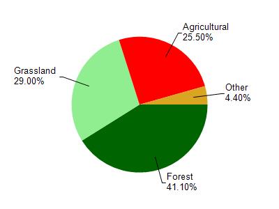
Watershed Characteristics
Jersey Valley Lake is located in the West Fork Kickapoo River watershed which is 118.04 mi². Land use in the watershed is primarily forest (41.10%), grassland (29%) and a mix of agricultural (25.50%) and other uses (4.40%). This watershed has 283.75 stream miles, 49.18 lake acres and 672.36 wetland acres.
Nonpoint Source Characteristics
This watershed is ranked High for runoff impacts on streams, Not Ranked for runoff impacts on lakes and High for runoff impacts on groundwater and therefore has an overall rank of High. This value can be used in ranking the watershed or individual waterbodies for grant funding under state and county programs.However, all waters are affected by diffuse pollutant sources regardless of initial water quality. Applications for specific runoff projects under state or county grant programs may be pursued. For more information, go to surface water program grants.