Grant
Yes
Yes
No
Fish and Aquatic Life
Overview
The Little Green River is a tributary of the Big Green. It is classified as a Class I trout stream
for 3.6 miles of its length. The river is also listed as an outstanding resource water (ORW). A
survey conducted in the summer of 2000 indicated an increase in the number of trout. The
Little Green River has been ranked as a high priority for nonpoint source pollution reduction.
Cattle grazing and trampling of streambanks is an apparent problem, and barnyards near the
stream may also be a problem.
From: Ripp, Coreen, Koperski, Cindy and Folstad, Jason. 2002. The State of the Lower Wisconsin River Basin.
PUBL WT-559-2002. Wisconsin Department of Natural Resources, Madison, WI.
Date 2002
Author Cynthia Koperski
Overview
The Little Green River is a tributary of the Big Green. It is classified as a Class I trout stream for 3.6 miles of its length. The river is also listed as an outstanding resource water (ORW). A survey conducted in the summer of 2000 indicated an increase in the number of trout. The Little Green River has been ranked as a high priority for nonpoint source pollution reduction. Cattle grazing and trampling of streambanks is an apparent problem, and barnyards near the stream may also be a problem.
Date 2001
Author Aquatic Biologist
Historical Description
From: Smith, Tom D., and Ball, Joseph R., Lake and Stream Classification Project. Surface Water Resources of Grant County, Department of Natural Resources, 1972. Surface Area = 2.91 acres, Length = 3.0 miles, Gradient = 33 ft./mile, Flow = 9.5 c.f.s.
A small spring-fed stream beginning 3.5 miles north of Mount Hope and flowing in a northerly direction to enter the lower reaches of the Big Green River. A two acre trout rearing pond was built on several headwater springs by the Department of Natural Resources in 1959. The pond and the state-owned land adjoining the pond is now known as the Mount Hope Conservation Area. The upper portion of this stream below the rearing pond is considered good brown trout water. Brown trout are common here and fishing pressure is heavy during the early part of the season. Some native trout have been found. Forage fish are common throughout the stream. The excellent water quality of the stream is limited by extensive areas of shallow gravel-rubble riffles. The entire stream remains practically ice-free during most of the winter. Bank cover is very abundant in the headwaters along the state-owned land but deteriorates to practically nothing on the lower two-thirds of the stream. A large recreation area with a 40-acre lake, several golf courses, a ski slope, several restaurants, and extensive executive office space was proposed to be built on the lower reaches of the stream in 1964.
This project, which never materialized, was to be financed by the Mid-American Ranch and Recreation Corporation of Madison, Wisconsin.
A feedlot located near one headwater spring remains a distinct eyesore from Highway 133 as well as being a pollution problem. Game assets are limited to a few muskrats and the major upland varieties. The Mount Hope Conservation Area provides 0.6 mile of public frontage on the stream in the upper reaches. The stream can also be easily reached from Highway 133, one bridge crossing, and the Big Green River. Seven rural dwellings adjoin the stream.
Date 1972
Author Surface Water Inventory Of Wisconsin
Condition
Wisconsin has over 84,000 miles of streams, 15,000 lakes and milllions of acres of wetlands. Assessing the condition of this vast amount of water is challenging. The state's water monitoring program uses a media-based, cross-program approach to analyze water condition. An updated monitoring strategy (2015-2020) is now available. Compliance with Clean Water Act fishable, swimmable standards are located in the Executive Summary of Water Condition in 2018. See also the 'monitoring and projects' tab.
Reports
Management Goals
Wisconsin's Water Quality Standards provide qualitative and quantitative goals for waters that are protective of Fishable, Swimmable conditions [Learn more]. Waters that do not meet water quality standards are considered impaired and restoration actions are planned and carried out until the water is once again fishable and swimmable
Management goals can include creation or implementation of a Total Maximum Daily Load analysis, a Nine Key Element Plan, or other restoration work, education and outreach and more. If specific recommendations exist for this water, they will be displayed below online.
Monitoring
Monitoring the condition of a river, stream, or lake includes gathering physical, chemical, biological, and habitat data. Comprehensive studies often gather all these parameters in great detail, while lighter assessment events will involve sampling physical, chemical and biological data such as macroinvertebrates. Aquatic macroinvertebrates and fish communities integrate watershed or catchment condition, providing great insight into overall ecosystem health. Chemical and habitat parameters tell researchers more about human induced problems including contaminated runoff, point source dischargers, or habitat issues that foster or limit the potential of aquatic communities to thrive in a given area. Wisconsin's Water Monitoring Strategy was recenty updated.
Grants and Management Projects
| Project Name (Click for Details) | Year Started |
|---|
|
|
Monitoring Projects
| WBIC | Official Waterbody Name | Station ID | Station Name | Earliest Fieldwork Date | Latest Fieldwork Date | View Station | View Data |
|---|
| 1204000 | Little Green River | 10058651 | Little Green River Spring | | | Map | Data |
| 1204000 | Little Green River | 10031475 | Little Green River at confluence of Big Green River | 1/1/2015 | 1/1/2015 | Map | Data |
| 1204000 | Little Green River | 10012848 | Little Green River - (Hwy 33) | | | Map | Data |
| 1204000 | Little Green River | 10030295 | Little Green R at N end of State Property | 1/1/2015 | 1/1/2015 | Map | Data |
| 1204000 | Little Green River | 10058650 | Little Green River Spring | | | Map | Data |
| 1204000 | Little Green River | 10047006 | Little Green River ~ 1865ft US from confluence with Big Green River | 1/1/2015 | 1/1/2015 | Map | Data |
|
Watershed Characteristics
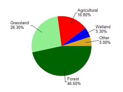
Little Green River is located in the Green River and Crooked Creek watershed which is 125.71 mi². Land use in the watershed is primarily forest (46.60%), grassland (26.30%) and a mix of agricultural (16.80%) and other uses (10.30%). This watershed has 278.95 stream miles, 257.04 lake acres and 4,127.32 wetland acres.
Nonpoint Source Characteristics
This watershed is ranked High for runoff impacts on streams, Not Ranked for runoff impacts on lakes and High for runoff impacts on groundwater and therefore has an overall rank of High. This value can be used in ranking the watershed or individual waterbodies for grant funding under state and county programs.However, all waters are affected by diffuse pollutant sources regardless of initial water quality. Applications for specific runoff projects under state or county grant programs may be pursued. For more information, go to surface water program grants.