Grant
No
No
No
Fish and Aquatic Life
Overview
Bullhead Slough is located on the Wisconsin River floodplain just northeast of Woodman. The slough is very shallow and winterkill is a problem. The fishery in the slough consists of northern pike, largemouth bass and panfish. The slough provides habitat for waterfowl during the spring and the fall. The water in the slough is tinted an orange or yellow color. According to water resource biologists, this discoloration is the result of anoxic conditions of the water near the bottom. As the water in the slough becomes anoxic, it causes iron to mobilize from the soil and enter the water column. This iron precipitates out and is thought to be the cause of the orange tint of the water.
Date 2002
Author Aquatic Biologist
Overview
Bullhead Slough is located on the Wisconsin River floodplain just northeast of Woodman. The slough is very shallow and winterkill is a problem. The fishery in the slough consists of northern pike, largemouth bass and panfish. The slough provides habitat for waterfowl during the spring and the fall.
The water in the slough is tinted an orange or yellow color. According to water resource biologists, this discoloration is the result of anoxic conditions of the water near the bottom. As the water in the slough becomes anoxic, it causes iron to mobilize from the soil and enter the water column. This iron precipitates out and is thought to be the cause of the orange tint of the water.
Date 2001
Author Aquatic Biologist
Historical Description
Source:1972, Surface Water Resources of Grant County,WI:WI-DNR Bullhead Slough: T7N, R3W, Sec. 7
A very shallow body of water located on the Wisconsin River floodplain one mile northeast of Woodman. Seepage is the primary source of water. Average depth is only one foot, therefore winterkill is an annual problem. Forage fish usually dominate the fishery but a limited sport fishery of northern pike and panfish exists when this area is flooded by the Wisconsin River. Due to the shallow depth this slough is considered to be deep marsh wetland adjoining the Wisconsin River. This productive wetland is excellent habitat for muskrat, beaver, mink, raccoon and deer. Waterfowl are common during the spring and fall. Walk-in access is possible with permission.
Surface area = 3.0 acres, S.D.F. = 2.60, maximum depth = 3 feet
Date 1972
Author Surface Water Inventory Of Wisconsin
Condition
Wisconsin has over 84,000 miles of streams, 15,000 lakes and milllions of acres of wetlands. Assessing the condition of this vast amount of water is challenging. The state's water monitoring program uses a media-based, cross-program approach to analyze water condition. An updated monitoring strategy (2015-2020) is now available. Compliance with Clean Water Act fishable, swimmable standards are located in the Executive Summary of Water Condition in 2018. See also the 'monitoring and projects' tab.
Management Goals
Wisconsin's Water Quality Standards provide qualitative and quantitative goals for waters that are protective of Fishable, Swimmable conditions [Learn more]. Waters that do not meet water quality standards are considered impaired and restoration actions are planned and carried out until the water is once again fishable and swimmable
Management goals can include creation or implementation of a Total Maximum Daily Load analysis, a Nine Key Element Plan, or other restoration work, education and outreach and more. If specific recommendations exist for this water, they will be displayed below online.
Monitoring
Monitoring the condition of a river, stream, or lake includes gathering physical, chemical, biological, and habitat data. Comprehensive studies often gather all these parameters in great detail, while lighter assessment events will involve sampling physical, chemical and biological data such as macroinvertebrates. Aquatic macroinvertebrates and fish communities integrate watershed or catchment condition, providing great insight into overall ecosystem health. Chemical and habitat parameters tell researchers more about human induced problems including contaminated runoff, point source dischargers, or habitat issues that foster or limit the potential of aquatic communities to thrive in a given area. Wisconsin's Water Monitoring Strategy was recenty updated.
Grants and Management Projects
Monitoring Projects
| WBIC | Official Waterbody Name | Station ID | Station Name | Earliest Fieldwork Date | Latest Fieldwork Date | View Station | View Data |
|---|
| 1205300 | Unnamed | 10036125 | Bullhead Slu - Main Area of Open Water South of Railroad Track | 8/4/2010 | 8/4/2010 | Map | Data |
| 1205400 | Bullhead Slu | 10036125 | Bullhead Slu - Main Area of Open Water South of Railroad Track | 8/4/2010 | 8/4/2010 | Map | Data |
| 1205400 | Bullhead Slu | 10036876 | Bullhead Slu - Small Area of Open Water North of Railroad Track | | | Map | Data |
| 1205400 | Bullhead Slu | 10035119 | Bullhead Slu- Small Portion of Open Water North of Railroad Track | | | Map | Data |
| 1205400 | Bullhead Slu | 10035093 | Bullhead Slu - Small Portion of Open Water North of Railroad Track | | | Map | Data |
| 1205400 | Bullhead Slu | 10020181 | Bullhead Slough -- Access | 6/18/2012 | 6/5/2020 | Map | Data |
| 1205400 | Bullhead Slu | 10035799 | Bullhead Slu - Small Area of Open Water North of Railroad Track | | | Map | Data |
| 1205400 | Bullhead Slu | 10035222 | Bullhead Slu - Medium-sized portion of Open Water North of Railroad Track | | | Map | Data |
|
Watershed Characteristics
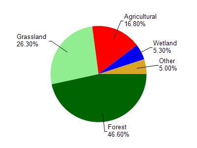
Bullhead Slu is located in the Green River and Crooked Creek watershed which is 125.71 mi². Land use in the watershed is primarily forest (46.60%), grassland (26.30%) and a mix of agricultural (16.80%) and other uses (10.30%). This watershed has 278.95 stream miles, 257.04 lake acres and 4,127.32 wetland acres.
Nonpoint Source Characteristics
This watershed is ranked High for runoff impacts on streams, Not Ranked for runoff impacts on lakes and High for runoff impacts on groundwater and therefore has an overall rank of High. This value can be used in ranking the watershed or individual waterbodies for grant funding under state and county programs.However, all waters are affected by diffuse pollutant sources regardless of initial water quality. Applications for specific runoff projects under state or county grant programs may be pursued. For more information, go to surface water program grants.