Iowa
Yes
Yes
No
Fish and Aquatic Life
Overview
Harker Creek is a tributary to Otter Creek below Blackhawk Lake and has a steeper gradient
than Otter Creek. It is a Class II and Class I trout stream with some natural reproduction of
brook trout and has been designated as exceptional resource water (ERW). In fact, Harker
Creek is thought to be one of the better trout streams in Iowa County. A rare aquatic species
has been found in the creek.
Surveys conducted in 2000 found water quality from fair to excellent. Fish that are indicators
of cold water and other species that are intolerant to water pollution were found and were
dominant at all sites. The presence of these species shows a marked improvement from
fishery survey results from the 1970ýs. The 2000 survey results suggest that the land use is
shifting from intensive agriculture to a more natural landscape. Overall, stream reaches are
well buffered with wetlands and support abundant wildlife. There is good aquatic vegetation
and a good supply of aquatic macroinvertebrates in the stream. Dissolved oxygen levels and
temperature readings were good and temperatures did not exceed 65.5 degrees Fahrenheit.
Despite the good water quality, there are also problems on the stream. A flood control dam
was constructed on the stream and can negatively impact water quality and temperature in
cold water streams. In addition, there is some evidence of grazing along the stream, with
banks exposed and eroding. As a result of nonpoint source problems, the stream has been
ranked as a high priority for nonpoint source pollution reduction. Overall, the transition from
agricultural to natural vegetation presents an opportunity to improve and maintain the water
quality and fishery in the stream through brush removal and habitat restoration. The state has
a small number of easements along a section of Harker Creek.
Citizen stream monitors have been actively monitoring Harker Creek since July 2000.
The volunteers monitor the creekýs turbidity, temperature and dissolved oxygen. To see the
data that these monitors have collected, please visit their website at
http://members.tripod.com/nohrchapter/monitor_home.htm.
From: Ripp, Coreen, Koperski, Cindy and Folstad, Jason. 2002. The State of the Lower Wisconsin River Basin. PUBL WT-559-2002. Wisconsin Department of Natural Resources, Madison, WI.
Date 2002
Author Cynthia Koperski
Historical Description
Harker Creek is a tributary to Otter Creek below Blackhawk Lake. It is a Class II trout stream (WDNR, 1980) It has been nominated to the state antidegradation list as an exceptional resource water (ERW) stream (WRM 1991). The stream has a steeper gradient than Otter Creek. There is some grazing along the stream, with banks exposed and eroding (WDNR, 1991).
Date 1994
Author Surface Water Inventory Of Wisconsin
Historical Description
Harker Lee Creek - Mouth location T6N R2E Section 3 - 8, Surface area = 4.1 acres, Length = 4.1 miles, Gradient = 53.7 feet per mile, Total alkalinity = 258.0 mg/l, Volume of flow = 4.2 cfs.
Springs form the principal source of water for this stream making it one of the better trout streams in Iowa County. Although it has a higher than average gradient, flooding and bank erosion are moderate, except in the lower sections, because of a broad valley located in the upper half of its basin.
Currently, there is a flood control dam (detention structure) being planned for this stream under Public Law 566, administered by the Department of Agriculture. It is to be located in the vicinity of the confluence of the Harker-Lee and Lee Creeks. Lee Creek is the only major tributary and contributes about 20 percent of its base flow. Springs are found in the upper half of its length where the natural reproduction of brown and brook trout are known to occur. Fingerling and legal-sized brown trout are stocked to supplement the fishery. Forage fishe, found during a seining survey include hog and white suckers; bluntnose and stoneroller minnows; redbelly and blacknose dace; hornyhead and creek chubs; bigmouth and common shiners; and johnny darters. Game assets include muskrats, which are common, and some migratory waterfowl. Public lands are lacking along this stream. Presently it is accessible from two town road crossings.
From: Piening, Ronald and Threinen, C.W., 1968. Lake and Stream Classification Project. Surface Water Resources of Iowa County, Wisconsin Department of Natural Resources, Madison, WI.
Date 1968
Author Surface Water Inventory Of Wisconsin
Condition
Wisconsin has over 84,000 miles of streams, 15,000 lakes and milllions of acres of wetlands. Assessing the condition of this vast amount of water is challenging. The state's water monitoring program uses a media-based, cross-program approach to analyze water condition. An updated monitoring strategy (2015-2020) is now available. Compliance with Clean Water Act fishable, swimmable standards are located in the Executive Summary of Water Condition in 2018. See also the 'monitoring and projects' tab.
Reports
Management Goals
Wisconsin's Water Quality Standards provide qualitative and quantitative goals for waters that are protective of Fishable, Swimmable conditions [Learn more]. Waters that do not meet water quality standards are considered impaired and restoration actions are planned and carried out until the water is once again fishable and swimmable
Management goals can include creation or implementation of a Total Maximum Daily Load analysis, a Nine Key Element Plan, or other restoration work, education and outreach and more. If specific recommendations exist for this water, they will be displayed below online.
Monitoring
Monitoring the condition of a river, stream, or lake includes gathering physical, chemical, biological, and habitat data. Comprehensive studies often gather all these parameters in great detail, while lighter assessment events will involve sampling physical, chemical and biological data such as macroinvertebrates. Aquatic macroinvertebrates and fish communities integrate watershed or catchment condition, providing great insight into overall ecosystem health. Chemical and habitat parameters tell researchers more about human induced problems including contaminated runoff, point source dischargers, or habitat issues that foster or limit the potential of aquatic communities to thrive in a given area. Wisconsin's Water Monitoring Strategy was recenty updated.
Grants and Management Projects
| Project Name (Click for Details) | Year Started |
|---|
|
|
Monitoring Projects
| WBIC | Official Waterbody Name | Station ID | Station Name | Earliest Fieldwork Date | Latest Fieldwork Date | View Station | View Data |
|---|
| 1238400 | Harker Creek | 10046820 | Harker Cr ~ 4000ft US Lee Cr confluence | 1/1/2015 | 1/1/2015 | Map | Data |
| 1238400 | Harker Creek | 10008031 | Harker Creek Tributary | 11/8/2000 | 11/8/2000 | Map | Data |
| 1238400 | Harker Creek | 10008021 | Harker Creek Station 4 | | | Map | Data |
| 1238400 | Harker Creek | 10008017 | Harker Creek Station 1 | 11/3/2000 | 10/29/2001 | Map | Data |
| 1238400 | Harker Creek | 10015836 | Harker Cr - 3 M Below Start Of Station 04 | 11/8/2000 | 11/8/2000 | Map | Data |
| 1238400 | Harker Creek | 10016400 | Harker Creek - 55m Upstream Pasture Fence- Abovespring/ See Map And Gps | 10/29/2001 | 10/29/2001 | Map | Data |
| 1238400 | Harker Creek | 10008029 | Harker Creek Station 7 | 11/8/2000 | 11/8/2000 | Map | Data |
| 1238400 | Harker Creek | 10046821 | Harker Cr at 2831 MT HOPE RD | 1/1/2015 | 1/1/2015 | Map | Data |
| 1238400 | Harker Creek | 10008018 | Harker Creek US confluence with Lee Creek | 7/1/2000 | 7/8/2024 | Map | Data |
| 1238400 | Harker Creek | 10008019 | Harker Creek Station 3 | | | Map | Data |
| 1238400 | Harker Creek | 10008027 | Harker Creek Station 6 | 11/8/2000 | 11/8/2000 | Map | Data |
| 1238400 | Harker Creek | 10022674 | Harker Cr Sation 2 T6n R3e Sec 10 Sese | 1/1/2015 | 1/1/2015 | Map | Data |
| 1238400 | Harker Creek | 10016354 | Harker Cr. - Path Crossing Stream 70 M Up Fromstart 03 | 11/8/2000 | 11/8/2000 | Map | Data |
| 1238400 | Harker Creek | 10022675 | Harker Cr Sation 3 T6n R2e Sec 14 Nwnw | 1/1/2015 | 1/1/2015 | Map | Data |
| 1238400 | Harker Creek | 10008022 | Harker Creek Station 5 | 11/8/2000 | 11/8/2000 | Map | Data |
| 1238400 | Harker Creek | 10046819 | Harker Cr at 3523 BERG RD | 1/1/2015 | 1/1/2015 | Map | Data |
| 1238400 | Harker Creek | 10008030 | Harker Creek Station 8 | 11/8/2000 | 11/8/2000 | Map | Data |
| 1238400 | Harker Creek | 10029199 | Harker Creek at Mount Hope Rd | 4/27/2004 | 8/6/2014 | Map | Data |
|
Watershed Characteristics
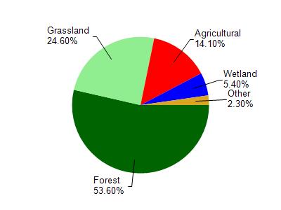
Harker Creek is located in the Otter and Morrey Creeks watershed which is 198.69 mi². Land use in the watershed is primarily forest (53.60%), grassland (24.60%) and a mix of agricultural (14.10%) and other uses (7.70%). This watershed has 437.57 stream miles, 351.55 lake acres and 5,785.74 wetland acres.
Nonpoint Source Characteristics
This watershed is ranked Not Ranked for runoff impacts on streams, Low for runoff impacts on lakes and High for runoff impacts on groundwater and therefore has an overall rank of High. This value can be used in ranking the watershed or individual waterbodies for grant funding under state and county programs.However, all waters are affected by diffuse pollutant sources regardless of initial water quality. Applications for specific runoff projects under state or county grant programs may be pursued. For more information, go to surface water program grants.