Iowa
No
No
No
Fish and Aquatic Life
Overview
This tributary to the Wisconsin River is fed by surface water runoff and groundwater seepage. The stream has a large volume of flow and is considered to have some potential for sport fishing, especially near its confluence with the Wisconsin River. The stream experiences problems with nonpoint source pollution. A rare aquatic species has been found in the creek in past surveys.
Date 2002
Author Cynthia Koperski
Historical Description
Blue Mounds Creek - Mouth location T8N R5E Section 9 -9, Surface area = 7.2 acres, Length = 27.2 miles, Gradient = 5.6 feet per mile, Total alkalinity = 266.0 mg/l, Volume of flow = 36.7 cfs.
Next to the Wisconsin River this stream has the second largest watershed and volune of flow in the county. It flows northerly to the Wisconsin River and its principal tributaries are Black Earth Creek and its West and East Branches. Although there are springs in its basin, its primary water source is surface runoff and groundwater seepage. Floods and bank erosion are recurring problems; especially during periods of heavy runoff even though its gradient is very low compared with the average county streams. The only possible source of pollution which exists in the county is from a cheese factory located on the lower section of the main stream. The effluent from this establishment is closely monitored by the Divisioh of Environmental Protection. The water quality of this stream throughout most of its length is suitable only for forage fishes; although northern pike and other game fish common to the Wisconsin River may be present near its mouth. Forage fishes which are present include the creek chub, sculpin, white sucker, bluhtnose minnow, spotfin shiner, brassy minnow and emerald shiner. Waterfowl and marshland furbearer populations can be considered significant; especially in the heavily wooded and lowland areas near the mouth. There are no lands in public ownership and it is accessible from seven road crossings.
From: Piening, Ronald and Threinen, C.W., Lake and Stream Classification Project. Surface Water Resources of Iowa County, Department of Natural Resources, 1968.
Date 1968
Author Surface Water Inventory Of Wisconsin
Condition
Wisconsin has over 84,000 miles of streams, 15,000 lakes and milllions of acres of wetlands. Assessing the condition of this vast amount of water is challenging. The state's water monitoring program uses a media-based, cross-program approach to analyze water condition. An updated monitoring strategy (2015-2020) is now available. Compliance with Clean Water Act fishable, swimmable standards are located in the Executive Summary of Water Condition in 2018. See also the 'monitoring and projects' tab.
Management Goals
Wisconsin's Water Quality Standards provide qualitative and quantitative goals for waters that are protective of Fishable, Swimmable conditions [Learn more]. Waters that do not meet water quality standards are considered impaired and restoration actions are planned and carried out until the water is once again fishable and swimmable
Management goals can include creation or implementation of a Total Maximum Daily Load analysis, a Nine Key Element Plan, or other restoration work, education and outreach and more. If specific recommendations exist for this water, they will be displayed below online.
Monitoring
Monitoring the condition of a river, stream, or lake includes gathering physical, chemical, biological, and habitat data. Comprehensive studies often gather all these parameters in great detail, while lighter assessment events will involve sampling physical, chemical and biological data such as macroinvertebrates. Aquatic macroinvertebrates and fish communities integrate watershed or catchment condition, providing great insight into overall ecosystem health. Chemical and habitat parameters tell researchers more about human induced problems including contaminated runoff, point source dischargers, or habitat issues that foster or limit the potential of aquatic communities to thrive in a given area. Wisconsin's Water Monitoring Strategy was recenty updated.
Grants and Management Projects
| Project Name (Click for Details) | Year Started |
|---|
|
|
Monitoring Projects
| WBIC | Official Waterbody Name | Station ID | Station Name | Earliest Fieldwork Date | Latest Fieldwork Date | View Station | View Data |
|---|
| 1248500 | Unnamed | 10031501 | Unnamed Slough Near Blue Mounds Creek Mouth | 7/19/2010 | 7/19/2010 | Map | Data |
| 5034392 | Unnamed | 10031501 | Unnamed Slough Near Blue Mounds Creek Mouth | 7/19/2010 | 7/19/2010 | Map | Data |
| 1248400 | Blue Mounds Creek | 10042002 | Blue Mounds Creek at Sawle Road | 4/18/2014 | 4/18/2014 | Map | Data |
| 1248400 | Blue Mounds Creek | 10016245 | Blue Mounds Creek at Hwy 14 | 5/25/1989 | 5/25/1989 | Map | Data |
|
Watershed Characteristics
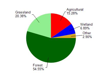
Blue Mounds Creek is located in the Mill and Blue Mounds Creek watershed which is 186.74 mi². Land use in the watershed is primarily forest (54.60%), grassland (20.40%) and a mix of agricultural (15.30%) and other uses (9.80%). This watershed has 382.87 stream miles, 106.91 lake acres and 6,596.99 wetland acres.
Nonpoint Source Characteristics
This watershed is ranked Medium for runoff impacts on streams, Low for runoff impacts on lakes and High for runoff impacts on groundwater and therefore has an overall rank of High. This value can be used in ranking the watershed or individual waterbodies for grant funding under state and county programs.However, all waters are affected by diffuse pollutant sources regardless of initial water quality. Applications for specific runoff projects under state or county grant programs may be pursued. For more information, go to surface water program grants.