Vernon
No
No
No
Fish and Aquatic Life
Overview
Field Veterans Memorial Lake, in the Seymour Creek and Upper Baraboo River Watershed, is a 43.28 acre lake that falls in Vernon County. This lake is managed for fishing and swimming and is currently not considered impaired.
Date 2011
Author Aquatic Biologist
Historical Description
Also known as Hillsboro Lake, Field Veterans Menrorial Lake is an impoundment of the
West Branch Baraboo River. South Branch Creek also flows into the lake. The lake is
highly eutrophic and has poor water quality, a problem found in almost all
impoundments in the driftless, or unglaciated portion of the state. This lake's water
quality problems are caused by excessive sedilnent loading, nutrient loading from
barnyards and cattle access to the stream, and high nitrate levels in groundwater
(Biebl, 1991). These sources have resulted in poor water clarity and algae blooms. The two
streams tributary to the lake carry a l-leavy sediment and nutrient load to the lake. The
Vernon County Land Conservation Department and the Hillsboro Lake Committee
obtained a lakes management grant and prepared a nonpoint source control plan for the
lake's watershed. The plan reconlmends extensive nonpoint source pollution controls
and limited in-lalre dredging to improve water quality and aquatic habitat.
Date 1994
Author Surface Water Inventory Of Wisconsin
Historical Description
Field-Veterans Memorial Lake (Hillsboro Pond), T14N, R1E, Section 35, Surface Acres = 42.2, S.D.F. = 1.83, Maximum Depth = 11.5 feet
This hard water, drainage impoundment is located on the South Branch of the Baraboo River in the City of Hillsboro. The West Branch of the Baraboo River joins the South Branch at the impoundment. The water level is controlled by a tainter gate and the dam is owned by the city. The light brown water is alkaline and at the time of survey, had low transparency. Following the rebuilding of the dam, in 1967, a chemical fish eradication program was carried out in the impounded area and the two inlet streams prior to closing the gate. Trout were stocked to provide immediate fishing, and the basic fishery management is for rainbow trout, largemouth bass and bluegill. There is a public picnic site, access from State Highway 80, and navigable water access. Wood ducks and teal nest at this lake, while puddle ducks, diving ducks, and Canada and Blue geese use it while migrating. No hunting is allowed within the city limits.
From: Klick, Thomas A. and Threinen, C.W. 1973. Lake and Stream Classification Project. Surface Water Resources of Vernon County, Wisconsin Department of Natural Resources, Madison, WI.
Date 1973
Author Surface Water Inventory Of Wisconsin
Condition
Wisconsin has over 84,000 miles of streams, 15,000 lakes and milllions of acres of wetlands. Assessing the condition of this vast amount of water is challenging. The state's water monitoring program uses a media-based, cross-program approach to analyze water condition. An updated monitoring strategy (2015-2020) is now available. Compliance with Clean Water Act fishable, swimmable standards are located in the Executive Summary of Water Condition in 2018. See also the 'monitoring and projects' tab.
Reports
Recommendations
County Land and Water Management Plan
The Vernon County Land Conservation Department proposes to reduce sedimentation to Hillsboro Lake by 1404 tons over a five year period through implementation of Best Management Practices approved, but unlikely to be funded at any time soon, by the state's Nonpoint Source Program. High Residue Management, Conservation Cropping Plans, Grassed Waterway, Critical Area Stabalization, Grade Stabalization Structures, Streambank Riprapping, Streambank Fencing, Stream Crossings and Streambank Shaping and Seeding.
Best Management Practices, Implement
The Vernon County Land Conservation Department proposes to reduce sedimentation to Hillsboro Lake by 1404 tons over a five year period through implementation of Best Management Practices approved, but unlikely to be funded at any time soon, by the state's Nonpoint Source Program. High Residue Management, Conservation Cropping Plans, Grassed Waterway, Critical Area Stabalization, Grade Stabalization Structures, Streambank Riprapping, Streambank Fencing, Stream Crossings and Streambank Shaping and Seeding.
Monitor Water Quality or Sediment
DNR should monitor Hillsboro Lake to determine lake health and condition.
Nine Key Element Plan
Hillsboro Priority PWS Plan - Nine Key Element Plan - The Hillsboro Priority Watershed Project plan assesses the nonpoint sources of pollution in the Hillsboro Watershed and guides the implementation of nonpoint source control measures.
Partnership Project
DNR should work with the Hillsboro School District to encourage environmental programs and citizen monitoring of streams and Hillsboro Lake through the Citizen Lake Management Network and the Water Action Volunteer Programs.
Management Goals
Wisconsin's Water Quality Standards provide qualitative and quantitative goals for waters that are protective of Fishable, Swimmable conditions [Learn more]. Waters that do not meet water quality standards are considered impaired and restoration actions are planned and carried out until the water is once again fishable and swimmable
Management goals can include creation or implementation of a Total Maximum Daily Load analysis, a Nine Key Element Plan, or other restoration work, education and outreach and more. If specific recommendations exist for this water, they will be displayed below online.
Monitoring
Monitoring the condition of a river, stream, or lake includes gathering physical, chemical, biological, and habitat data. Comprehensive studies often gather all these parameters in great detail, while lighter assessment events will involve sampling physical, chemical and biological data such as macroinvertebrates. Aquatic macroinvertebrates and fish communities integrate watershed or catchment condition, providing great insight into overall ecosystem health. Chemical and habitat parameters tell researchers more about human induced problems including contaminated runoff, point source dischargers, or habitat issues that foster or limit the potential of aquatic communities to thrive in a given area. Wisconsin's Water Monitoring Strategy was recenty updated.
Grants and Management Projects
Monitoring Projects
| WBIC | Official Waterbody Name | Station ID | Station Name | Earliest Fieldwork Date | Latest Fieldwork Date | View Station | View Data |
|---|
| 1289700 | Field Veterans Memorial Lake | 633122 | Field Veterans Memorial Lake - Deep Hole | 7/13/1973 | 6/4/1990 | Map | Data |
| 1289700 | Field Veterans Memorial Lake | 10005953 | Field Veterans Memorial Lake | 4/8/1989 | 6/12/2020 | Map | Data |
| 1289700 | Field Veterans Memorial Lake | 10017494 | Field Veterans Memorial Lake -- Access | 3/19/2012 | 3/19/2012 | Map | Data |
| 1289700 | Field Veterans Memorial Lake | 10017495 | Field Veterans Memorial Lake -- Access Nr 80 | 11/29/2023 | 9/12/2024 | Map | Data |
| 1289700 | Field Veterans Memorial Lake | 634001 | Hillsboro Pond - Hillsboro Pond | 8/28/1979 | 8/6/2025 | Map | Data |
|
Watershed Characteristics
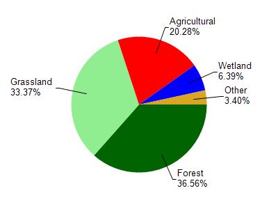
Field Veterans Memorial Lake is located in the Seymour Creek and Upper Baraboo River watershed which is 171.73 mi². Land use in the watershed is primarily forest (36.60%), grassland (33.40%) and a mix of agricultural (20.30%) and other uses (9.80%). This watershed has 414.62 stream miles, 124.03 lake acres and 4,637.96 wetland acres.
Nonpoint Source Characteristics
This watershed is ranked Medium for runoff impacts on streams, Not Ranked for runoff impacts on lakes and High for runoff impacts on groundwater and therefore has an overall rank of High. This value can be used in ranking the watershed or individual waterbodies for grant funding under state and county programs.However, all waters are affected by diffuse pollutant sources regardless of initial water quality. Applications for specific runoff projects under state or county grant programs may be pursued. For more information, go to surface water program grants.