Green
No
No
Yes
Fish and Aquatic Life
Overview
Twin Grove Branch
Twin Grove Branch is located in southern Green County and is part of the Honey and Richland Creek watersheds.
Originating just east of the town of Twin Grove, the six-mile long stream flows westward and empties into Richland
Creek. The entire length of Twin Grove Branch is currently listed on the 303(d) list for degraded habitat resulting
from sedimentation due to agricultural non-point source pollution. Fish surveys from 1974 and 1976 found 17 species
of forage and minnow species between two different locations near the mouth of the stream. The most abundant
species found were central stonerollers, white sucker, and creek chub; however, the stream has not been monitored in
recent years. Twin Grove Branch currently supports a warm water forage fishery, but is believed to have the potential
to become a warm water sport fishery.
Date 2002
Author Aquatic Biologist
Overview
This stream small warm water stream is listed on the state’s impaired waters (303d) list because of habitat and sedimentation impacts caused by agricultural non-point source pollution. The headwaters begin east of the town of Twin Grove and flows westward to Richland Creek. The creek has the potential to be a warm water sport fishery because of migration of fish from the larger Richland Creek. The stream has not been monitored in recent years.
Date 2002
Author Aquatic Biologist
Overview
This stream small warm water stream is listed on the state
**18**
s impaired waters (303d) list because of habitat and sedimentation impacts caused by agricultural non-point source pollution. The headwaters begin east of the town of Twin Grove and flows westward to Richland Creek. The creek has the potential to be a warm water sport fishery because of migration of fish from the larger Richland Creek. The stream has not been monitored in recent years. From: Poff, Ronald J., and C.W. Threinen, Lake and Stream Classification Project. Surface Water Resources of Green County, Wisconsin Conservation Department, Madison I, 1961.
Date 1961
Author Aquatic Biologist
Historical Description
Bush, D.M., R. Cornelius, D. Engle, and C.L. Brynildson. 1980. Lake and Stream Classification Project. Surface Water Resources of Green County, 2nd Edition. Wisconsin Department of Natural Resources, Madison, Wisconsin.
This small warmwater stream oriqinates east of Twin Grove and flows westward to Richland Creek. Several small
ponds lie near its headwaters. -Most of the creek runs through permanent pasture and suffers heavy bank erosion and moderate siltation. The water is clear however, and gravel and rubble dominate the substrate. Sand, boulders and hardpan are also present.
Twin Grov~ Branch is managed for forage fish although a few smallmouth bass, green sunfish and black bullheads can be found in the lower end. Wildlife values consist of a small population of muskrats. Public access is available from four road bridges. There is no other public frontage, but the stream flows through a nine
hole, privately owned golf course which is open to the public.
Fish Species: Central stoneroller, hornyhead chub, common shiner, bigmouth shiner, suckermouth minnow, southern redbelly dace, bluntnose minnow, fathead minnow, blacknose dace, creek chub, white sucker, black bullhead,
green sunfish, smallmouth bass, fantail darter, Johnny darter.
Surface Acres = 3.3, Length = 5.5 Miles, Gradient = 16 ft./mi., Base Discharge = 6.2 cu. ft./sec.
Date 1980
Author Surface Water Inventory Of Wisconsin
Condition
Wisconsin has over 84,000 miles of streams, 15,000 lakes and milllions of acres of wetlands. Assessing the condition of this vast amount of water is challenging. The state's water monitoring program uses a media-based, cross-program approach to analyze water condition. An updated monitoring strategy (2015-2020) is now available. Compliance with Clean Water Act fishable, swimmable standards are located in the Executive Summary of Water Condition in 2018. See also the 'monitoring and projects' tab.
Reports
Management Goals
Wisconsin's Water Quality Standards provide qualitative and quantitative goals for waters that are protective of Fishable, Swimmable conditions [Learn more]. Waters that do not meet water quality standards are considered impaired and restoration actions are planned and carried out until the water is once again fishable and swimmable
Management goals can include creation or implementation of a Total Maximum Daily Load analysis, a Nine Key Element Plan, or other restoration work, education and outreach and more. If specific recommendations exist for this water, they will be displayed below online.
Monitoring
Monitoring the condition of a river, stream, or lake includes gathering physical, chemical, biological, and habitat data. Comprehensive studies often gather all these parameters in great detail, while lighter assessment events will involve sampling physical, chemical and biological data such as macroinvertebrates. Aquatic macroinvertebrates and fish communities integrate watershed or catchment condition, providing great insight into overall ecosystem health. Chemical and habitat parameters tell researchers more about human induced problems including contaminated runoff, point source dischargers, or habitat issues that foster or limit the potential of aquatic communities to thrive in a given area. Wisconsin's Water Monitoring Strategy was recenty updated.
Grants and Management Projects
| Project Name (Click for Details) | Year Started |
|---|
|
|
Monitoring Projects
| WBIC | Official Waterbody Name | Station ID | Station Name | Earliest Fieldwork Date | Latest Fieldwork Date | View Station | View Data |
|---|
| 891300 | Twin Grove Br | 10013082 | Twin Grove Branch 100 M Upstream Of Rahberger Rd. (Past Golf Course) | | | Map | Data |
| 891300 | Twin Grove Br | 10047833 | Twin Grove Branch at Twin Grove Road | | | Map | Data |
| 891300 | Twin Grove Br | 10016358 | Twin Grove Br. - Cth P | 10/29/1987 | 7/21/2015 | Map | Data |
| 891300 | Twin Grove Br | 233099 | Twin Grove Branch - Town Rd bridge below Jeffsn Ctr upstream Twin Grove Rd | 10/7/2010 | 1/1/2015 | Map | Data |
| 891300 | Twin Grove Br | 233097 | Twin Grove Branch at Cth K | | | Map | Data |
|
Watershed Characteristics
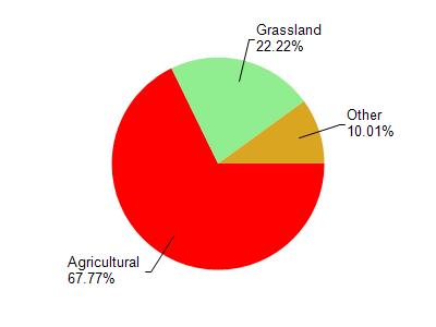
Twin Grove Br is located in the Honey and Richland Creeks watershed which is 80.09 mi². Land use in the watershed is primarily agricultural (67.70%), grassland (22.20%) and a mix of suburban (4.40%) and other uses (5.60%). This watershed has 195.33 stream miles, 16.47 lake acres and 117.89 wetland acres.
Nonpoint Source Characteristics
This watershed is ranked Medium for runoff impacts on streams, Not Ranked for runoff impacts on lakes and High for runoff impacts on groundwater and therefore has an overall rank of High. This value can be used in ranking the watershed or individual waterbodies for grant funding under state and county programs.This water is ranked High Stream for individual Rivers based on runoff problems and the likelihood of success from project implementation.