Lafayette
No
No
Yes
Fish and Aquatic Life
Overview
Otter Creek is one of the major warm water drainage streams of Lafayette County, flowing 19 miles southward into the West Branch of the Pecatonica River. The Bureau of Research has been sampling the stream over the last decade in order to determine if stream habitat improvement can increase populations of smallmouth bass. Historically, Otter Creek had good smallmouth bass populations, but these populations declined due to poor habitat. Additionally, the creek has suffered regular fish kills as a result of manure runoff. The creek has been part of the Stewardship Streambank program where the department will attempt to attain easements where water quality problems need to be addressed such as feedlots or barnyards. In 1993 and 1994, Sport Fish Restoration efforts were made to improve habitat. To date, easements have been obtained, however, stream improvement work has not been conducted on the stream due to poor water quality (Sims, pers. comm.). Despite these measures, the smallmouth bass populations have not improved. A 2001 baseline survey confirmed that this is a warm water sport fishery, but that it is on the decline. The fish population was further impacted by a fish kill during the same year that resulted from the overflow of a manure slurry pit. The Bureau of Research continues to monitor the stream as a part of the original project.
Date 2002
Author Aquatic Biologist
Historical Description
Otter Creek (in Lafayette County) - Mouth location T4N R3E Section 14 -11, Surface area = 2.2 acres, Length = 31 miles, Gradient = 29.0 feet per mile, Total alkalinity = 268.0 mg/l, volume of flow = 0.5 cfs.
This stream and one of its tributaries begins in Iowa County and flows southward into Lafayette County where it becomes fairly large and enters the West Branch of the Pecatonica River. Almost 100 percent of its watershed
area is cleared and farmed intensively and results in the rapid runoff of the surface waters during periods of heavy precipitation; therefore bank erosion is heavy in most sections. Its principal water source is seepage and although it becomes a fine smallmouth bass and channel catfish in Lafayette County, water depth and volume limit its fishery to forage types in Iowa County. A brief seining survey revealed that species present include white suckers, bluntnose and stoneroller minnows, common shiners, creek chubs, brook sticklebacks, and fantail and johnny darters. Aquatic game assets are limited to some muskrats in the wider and deeper sections. There are no public lands but it is accessible from three road crossings.
From: Piening, Ronald and Threinen, C.W., 1968. Lake and Stream Classification Project. Surface Water Resources of Iowa County, Wisconsin Department of Natural Resources, Madison, WI.
Date 1968
Author Surface Water Inventory Of Wisconsin
Historical Description
Otter Creek; T3N, R3E, Sections 6-10, Surface acres = 32.6, Miles = 12.3, Gradient = 14.6,Total alkalinity = 294 mg/l, Volume of flow = 14.7 cfs.
As one of the major warm water drainage streams of Layfayette County, Otter Creek flows in a southerly direction into the West Branch of the Pecatonica River. Although there is only one named stream in the Otter Creek system, it is one of the most complex in the county. There are thirteen feeder streams which contribute a total base flow of 4.4 cfs, for 28 percent of Otter Creek's volume. Moderate to heavy bank erosion is common throughout its length since much flooding takes place during periods of heavy runoff. The majority of the floodplain and bottoms on the upper parts of Otter Creek are wooded while the same areas on the lower parts are generally in firm pasture and cropland. The areas immediately above the floodplain are mostly in agricultural crops throughout the watershed. The sport fishery consists of a good smallmouth bass population which extends from the mouth upstream about six miles. Channel catfish are common in the lower one-half of the stream. Brown trout are known to frequent the stream system, but are present in limited numbers. The stream bottom throughout its length is equally divided between gravel and rubble. The wooded stream banks provide nesting habitat for waterfowl and support a significant population of muskrats. Deer and other upland game species common to the county are found in and above the floodplain. Although there is no public land on the stream at the present time, access is possible from eight road bridges at various points along the stream's length.
From: Piening, Ronald; Poff, Ronald; Threinen, C.W., 1967. Lake and Stream Classification Project. Surface Water Resources of Lafayette County, Wisconsin Department of Natural Resources, Madison, WI.
Date 1967
Author Surface Water Inventory Of Wisconsin
Impaired Waters
This water was assessed during the 2016 listing cycle; regional biologist recommended listing for BOD and ammonia because they have caused fish kill incidents over the past 25 years.
Date 2015
Author Aaron Larson
Condition
Wisconsin has over 84,000 miles of streams, 15,000 lakes and milllions of acres of wetlands. Assessing the condition of this vast amount of water is challenging. The state's water monitoring program uses a media-based, cross-program approach to analyze water condition. An updated monitoring strategy (2015-2020) is now available. Compliance with Clean Water Act fishable, swimmable standards are located in the Executive Summary of Water Condition in 2018. See also the 'monitoring and projects' tab.
Reports
Management Goals
Wisconsin's Water Quality Standards provide qualitative and quantitative goals for waters that are protective of Fishable, Swimmable conditions [Learn more]. Waters that do not meet water quality standards are considered impaired and restoration actions are planned and carried out until the water is once again fishable and swimmable
Management goals can include creation or implementation of a Total Maximum Daily Load analysis, a Nine Key Element Plan, or other restoration work, education and outreach and more. If specific recommendations exist for this water, they will be displayed below online.
Monitoring
Monitoring the condition of a river, stream, or lake includes gathering physical, chemical, biological, and habitat data. Comprehensive studies often gather all these parameters in great detail, while lighter assessment events will involve sampling physical, chemical and biological data such as macroinvertebrates. Aquatic macroinvertebrates and fish communities integrate watershed or catchment condition, providing great insight into overall ecosystem health. Chemical and habitat parameters tell researchers more about human induced problems including contaminated runoff, point source dischargers, or habitat issues that foster or limit the potential of aquatic communities to thrive in a given area. Wisconsin's Water Monitoring Strategy was recenty updated.
Grants and Management Projects
Monitoring Projects
| WBIC | Official Waterbody Name | Station ID | Station Name | Earliest Fieldwork Date | Latest Fieldwork Date | View Station | View Data |
|---|
| 923300 | Otter Creek | 104450 | Otter Creek | | | Map | Data |
| 923300 | Otter Creek | 10044210 | Otter Creek at CTH F | | | Map | Data |
| 923300 | Otter Creek | 10008007 | Otter Cr. Station 3-Furnace Hill Rd | 11/14/2000 | 1/1/2015 | Map | Data |
| 923300 | Otter Creek | 10008006 | Otter Cr. Station 2-Woodberry Rd | | | Map | Data |
| 923300 | Otter Creek | 10008005 | Otter Cr. Station 1 (STH 81) | 11/14/2000 | 10/16/2023 | Map | Data |
| 923300 | Otter Creek | 333229 | Otter Creek at Wildcat Rd | | | Map | Data |
|
Watershed Characteristics
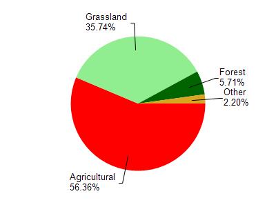
Otter Creek is located in the Middle Pecatonica River watershed which is 186.42 mi². Land use in the watershed is primarily agricultural (56.30%), grassland (35.70%) and a mix of forest (5.70%) and other uses (2.20%). This watershed has 484.82 stream miles, 27.78 lake acres and 298.28 wetland acres.
Nonpoint Source Characteristics
This watershed is ranked Not Ranked for runoff impacts on streams, Not Ranked for runoff impacts on lakes and High for runoff impacts on groundwater and therefore has an overall rank of High. This value can be used in ranking the watershed or individual waterbodies for grant funding under state and county programs.This water is ranked High Stream for individual Rivers based on runoff problems and the likelihood of success from project implementation.