Culver Br, Platte River Watershed (GP02)
Culver Br (950900)
1.94 Miles
2.30 - 4.24
Natural Community
Natural communities (stream and lake natural communities) represent model results that use predicted flow and temperature based on landscape features and related assumptions. Ranges of flow and temperature associated with specific aquatic life communities (fish, macroinvertebrates) help biologists identify appropriate resource management goals. Wisconsin Natural Communities.
Cool-Cold Headwater, Coldwater
Year Last Monitored
This is the most recent date of monitoring data stored in SWIMS. Additional surveys for fish and habitat may be available subsequent to this date.
Good
 
Grant
Trout Water 
Trout Waters are represented by Class I, Class II or Class III waters. These classes have specific ecological characteristics and management actions associated with them. For more information regarding Trout Classifications, see the Fisheries Trout Class Webpages.
Yes
Outstanding or Exceptional 
Wisconsin has designated many of the state's highest quality waters as Outstanding Resource Waters (ORWs) or Exceptional Resource Waters (ERWs). Waters designated as ORW or ERW are surface waters which provide outstanding recreational opportunities, support valuable fisheries and wildlife habitat, have good water quality, and are not significantly impacted by human activities. ORW and ERW status identifies waters that the State of Wisconsin has determined warrant additional protection from the effects of pollution. These designations are intended to meet federal Clean Water Act obligations requiring Wisconsin to adopt an 'antidegradation' policy that is designed to prevent any lowering of water quality - especially in those waters having significant ecological or cultural value.
No
Impaired Water 
A water is polluted or 'impaired' if it does not support full use by humans, wildlife, fish and other aquatic life and it is shown that one or more of the pollutant criteria are not met.
No

Fish and Aquatic Life

Current Use
The use the water currently supports. This is not a designation or classification; it is based on the current condition of the water. Information in this column is not designed for, and should not be used for, regulatory purposes.
Supported Aquatic Life
Waters that support fish and aquatic life communities (healthy biological communities).
Attainable Use
The use that the investigator believes the water could achieve through managing "controllable" sources. Beaver dams, hydroelectric dams, low gradient streams, and naturally occurring low flows are generally not considered controllable. The attainable use may be the same as the current use or it may be higher.
Cold
Streams capable of supporting a cold water sport fishery, or serving as a spawning area for salmonids and other cold water fish species. Representative aquatic life communities, associated with these waters, generally require cold temperatures and concentrations of dissolved oxygen that remain above 6 mg/L. Since these waters are capable of supporting natural reproduction, a minimum dissolved oxygen concentration of 7 mg/L is required during times of active spawning and support of early life stages of newly-hatched fish.
Designated Use
This is the water classification legally recognized by NR102 and NR104, Wis. Adm. Code. The classification determines water quality criteria and effluent limits. Waters obtain designated uses through classification procedures.
Cold
Streams capable of supporting a cold water sport fishery, or serving as a spawning area for salmonids and other cold water fish species. Representative aquatic life communities, associated with these waters, generally require cold temperatures and concentrations of dissolved oxygen that remain above 6 mg/L. Since these waters are capable of supporting natural reproduction, a minimum dissolved oxygen concentration of 7 mg/L is required during times of active spawning and support of early life stages of newly-hatched fish.

Overview

Culver Branch is a spring fed tributary to the Platte River just south of the community of Ellenboro. It is considered a class II trout stream (WDNR, 1980). Its biological and recreational uses have been impaired over the years by agricultural nonpoint sources of pollution resulting in its listing on the 303(d) list of impaired waters. A species listed on the state’s threatened and endangered species list has historically been found along Culver Branch (WDNR, 1997). This endangered species is very sensitive to water pollution. Nonpoint source best management practices, particularly stream buffer corridors and managed grazing, would help protect and improve the stream.

Date  2001

Author   Aquatic Biologist

Historical Description

Entire stream.

Date  1980

Author   Surface Water Inventory Of Wisconsin

Historical Description

From: Smith, Tom D., and Ball, Joseph R., Lake and Stream Classification Project. Surface Water Resources of Grant County, Department of Natural Resources, 1972. Surface Area = 2.09 acres, Length = 2.3 miles, Gradient = 43 ft./mile, Flow = 2.5 c.f.s.

A rocky, spring-fed tributary of the Platte River located two miles south of Ellenboro. Firm pasture is the predominant bank type and some fairly deep pool areas are found throughout the stream. Brown trout have been stocked by the Platteville SportsmanB Club, but the stream is only considered as very marginal trout water. Forage fish including white suckers, bluntnose minnows, and creek chubs are commonly observed. Game assets including deer, raccoon, squirrels, and ruffed grouse are present in the watershed. One bridge crossing and the Platte River provide access. Only one dwelling is seen along the banks.

Date  1972

Author   Surface Water Inventory Of Wisconsin

Culver Br, Platte River Watershed (GP02) Fish and Aquatic LifeCulver Br, Platte River Watershed (GP02) RecreationCulver Br, Platte River Watershed (GP02) Fish Consumption

Condition

Wisconsin has over 84,000 miles of streams, 15,000 lakes and milllions of acres of wetlands. Assessing the condition of this vast amount of water is challenging. The state's water monitoring program uses a media-based, cross-program approach to analyze water condition. An updated monitoring strategy (2015-2020) is now available. Compliance with Clean Water Act fishable, swimmable standards are located in the Executive Summary of Water Condition in 2018. See also the 'monitoring and projects' tab.

Reports

Recommendations

Monitor Watershed (Status,Sources,Impairments)
Document monitoring conducted to de-list from impaired waters list.

Management Goals

Wisconsin's Water Quality Standards provide qualitative and quantitative goals for waters that are protective of Fishable, Swimmable conditions [Learn more]. Waters that do not meet water quality standards are considered impaired and restoration actions are planned and carried out until the water is once again fishable and swimmable

Management goals can include creation or implementation of a Total Maximum Daily Load analysis, a Nine Key Element Plan, or other restoration work, education and outreach and more. If specific recommendations exist for this water, they will be displayed below online.

Monitoring

Monitoring the condition of a river, stream, or lake includes gathering physical, chemical, biological, and habitat data. Comprehensive studies often gather all these parameters in great detail, while lighter assessment events will involve sampling physical, chemical and biological data such as macroinvertebrates. Aquatic macroinvertebrates and fish communities integrate watershed or catchment condition, providing great insight into overall ecosystem health. Chemical and habitat parameters tell researchers more about human induced problems including contaminated runoff, point source dischargers, or habitat issues that foster or limit the potential of aquatic communities to thrive in a given area. Wisconsin's Water Monitoring Strategy was recenty updated.

Grants and Management Projects

Monitoring Projects

Watershed Characteristics

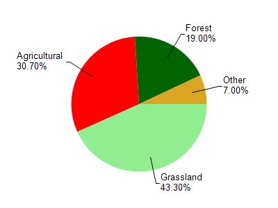
Culver Br is located in the Platte River watershed which is 197.74 miĀ². Land use in the watershed is primarily grassland (43.30%), agricultural (30.70%) and a mix of forest (19%) and other uses (7.00%). This watershed has 455.07 stream miles, 21.45 lake acres and 1,303.48 wetland acres.

Nonpoint Source Characteristics

This watershed is ranked Medium for runoff impacts on streams, Not Available for runoff impacts on lakes and High for runoff impacts on groundwater and therefore has an overall rank of High. This value can be used in ranking the watershed or individual waterbodies for grant funding under state and county programs.This water is ranked High Stream for individual Rivers based on runoff problems and the likelihood of success from project implementation.

Natural Community

Culver Br is considered a Cool-Cold Headwater, Coldwater under the state's Natural Community Determinations.

Natural communities (stream and lake natural communities) represent model results and DNR staff valiation processes that confirm or update predicted conditions based on flow and temperature modeling from historic and current landscape features and related variables. Predicated flow and temperatures for waters are associated predicated fish assemblages (communities). Biologists evaluate the model results against current survey data to determine if the modeled results are corect and whether biological indicators show water quaity degradation. This analysis is a core component of the state's resource management framework. Wisconsin's Riverine Natural Communities.

Cool (Cold-Transition) Headwaters are small, usually perennial streams with cold to cool summer temperatures. Coldwater fishes are common to uncommon (<10 per 100 m), transitional fishes are abundant to common, and warm water fishes are uncommon to absent. Headwater species are abundant to common, mainstem species are common to absent, and river species are absent.