Grant
No
No
Yes
Fish and Aquatic Life
Overview
Rattlesnake Creek is a spring and seepage stream that begins southeast of Bagley and flows southwest to enter the Grant River near Beetown. Almost 100% of its drainage area is used for agricultural purposes. The stream has experienced problems with non-point source pollution. A study done by USGS on Rattlesnake Creek showed the stream carries a median unit-area load (tons per square mile) of sediment of 200 tons per square mile with a maximum load of 837 tons of sediment per square mile. The same study showed the stream received a median unit-area load of 821 pounds of phosphorus per square mile with a maximum loading of 3,670 pounds per square mile (Corsi, et.al, 1997).
Historically, it was a good smallmouth bass stream (Smith and Ball, 1971). However, while investigations during the 1980's showed that Rattlesnake had good to excellent smallmouth bass habitat, the stream had a very low population of smallmouth bass (Forbes, 1985). The population of smallmouth bass in the creek tends to fluctuate. The key factor in this fluctuation seems to be major runoff events that result in dissolved oxygen levels that fall below state water quality standards. These low dissolved oxygen levels are thought to be caused by runoff from barnyards in the watershed (Wang, et.al., 1996).
Recent observations, however, have indicated that the bass fishery has improved (Kerr, 1998; Wang et.al., 1996). The IBI ratings, indicators of environmental degradation, for Rattlesnake Creek were generally fair. Macroinvertebrate monitoring indicate a range in water quality from “fair” to “poor” (Marshall, 1999). Overall macroinvertebrate sampling found nearly 25% of the macroinvertebrates to be mayflies, stoneflies or caddisflies while approximately 55% of the samples were midges (Marshall, 1999). In addition, stream habitat was rated as being good to excellent (Wang et.al., 1996).
Date 2001
Author Aquatic Biologist
Historical Description
From: Smith, Tom D., and Ball, Joseph R., Lake and Stream Classification Project. Surface Water Resources of Grant County, Department of Natural Resources, 1972. Surface Area = 38.73 acres, J.ength = 21.3 miles, Gradient = 16 ft./mile, Flow = 12.3 c.f.s.
A seepage and spring-fed stream beginning five miles southeast of Bagley and flowing southeast to enter the Grant River two miles south of Beetown. The portion of st:ream between North Andover and Highway 61 is very picturesque with high limestone outcrops. Many meanders, steep-.cut banks, and deep slow-moving water characterizes the lower reaches of the stream. It is considered to be a fairly good smallmouth bass stream, but only a low density of srnallmouth were found during an electroshocking inventory in 1958. Forage species are commen to abundant throughout and they have been taken by commercial bait dealers in the past. Channel catfish and rough fish are also present in the lower reaches. Aquatic game assets include muskrat, mink, beaver, and a few migratory waterfowl. The various upland game species are also common throughout the watershed. Rapid runoff and subsequent severe bank erosion are major problems. Many portions of the stream have been straightened in an effort to protect valuable farmland destroyed by stream bank erosion. Better soil and water control practices are needed in order to prevent further depletion of stream habitat due to stream straightening. A severe fish kill from undetermined causes was reported on this stream during the summer of 1971. Public access is possible from the Grant River and 11 bridge crossings. A total of 16 dwellings are located along the banks.
Date 1972
Author Surface Water Inventory Of Wisconsin
Impaired Waters
Rattlesnake Creek (957300) was assessed during the 2016 listing cycle; the regional biologist recommended listing for degraded biological community based on current and historical Poor mIBI scores. This water is considered impaired and not meeting its Fish and Aquatic Life use.
Date 2015
Author Aaron Larson
Condition
Wisconsin has over 84,000 miles of streams, 15,000 lakes and milllions of acres of wetlands. Assessing the condition of this vast amount of water is challenging. The state's water monitoring program uses a media-based, cross-program approach to analyze water condition. An updated monitoring strategy (2015-2020) is now available. Compliance with Clean Water Act fishable, swimmable standards are located in the Executive Summary of Water Condition in 2018. See also the 'monitoring and projects' tab.
Reports
Management Goals
Wisconsin's Water Quality Standards provide qualitative and quantitative goals for waters that are protective of Fishable, Swimmable conditions [Learn more]. Waters that do not meet water quality standards are considered impaired and restoration actions are planned and carried out until the water is once again fishable and swimmable
Management goals can include creation or implementation of a Total Maximum Daily Load analysis, a Nine Key Element Plan, or other restoration work, education and outreach and more. If specific recommendations exist for this water, they will be displayed below online.
Monitoring
Monitoring the condition of a river, stream, or lake includes gathering physical, chemical, biological, and habitat data. Comprehensive studies often gather all these parameters in great detail, while lighter assessment events will involve sampling physical, chemical and biological data such as macroinvertebrates. Aquatic macroinvertebrates and fish communities integrate watershed or catchment condition, providing great insight into overall ecosystem health. Chemical and habitat parameters tell researchers more about human induced problems including contaminated runoff, point source dischargers, or habitat issues that foster or limit the potential of aquatic communities to thrive in a given area. Wisconsin's Water Monitoring Strategy was recenty updated.
Grants and Management Projects
| Project Name (Click for Details) | Year Started |
|---|
|
|
Monitoring Projects
| WBIC | Official Waterbody Name | Station ID | Station Name | Earliest Fieldwork Date | Latest Fieldwork Date | View Station | View Data |
|---|
| 957300 | Rattlesnake Creek | 10010498 | Rattlesnake Creek - 2 | | | Map | Data |
| 957300 | Rattlesnake Creek | 10038481 | Rattlesnake Creek along Rattlesnake Road - Farm lane at 9973 Rattlesnake Rd | 8/21/2012 | 1/1/2015 | Map | Data |
| 957300 | Rattlesnake Creek | 10016893 | Rattlesnake Cr At Hwy 133 - Hwy 133 Downstream Approx 100 Feet First And Second Riffles | 4/8/1990 | 1/1/2015 | Map | Data |
| 957300 | Rattlesnake Creek | 223211 | Rattlesnake Creek - Maine Rd. | 4/16/1980 | 4/8/1990 | Map | Data |
| 957300 | Rattlesnake Creek | 223264 | Rattlesnake Creek - Rattlesnake Creek At Hwy 81 | 10/15/1989 | 1/1/2015 | Map | Data |
| 957300 | Rattlesnake Creek | 10040151 | Rattlesnake Creek 0.5mi W of Hwy 81 | 9/11/2013 | 1/1/2015 | Map | Data |
| 957300 | Rattlesnake Creek | 10010503 | Rattlesnake Creek 4 | 10/16/1990 | 1/1/2015 | Map | Data |
| 957300 | Rattlesnake Creek | 10016892 | Rattlesnake Cr. At Hwy 133 - Hwy 133 Downstream Approx 100 Feet First Riffle | 10/24/1984 | 10/15/1989 | Map | Data |
| 957300 | Rattlesnake Creek | 223213 | Rattlesnake Creek - Glassmaker Rd. | 4/16/1980 | 1/1/2015 | Map | Data |
| 957300 | Rattlesnake Creek | 10049098 | Rattlesnake Creek - 40m US Rattlesnake road bridge | | | Map | Data |
| 957300 | Rattlesnake Creek | 223261 | Rattlesnake Creek at Muskallounge Rd Near North Andover WI | 6/2/1992 | 1/1/2015 | Map | Data |
| 957300 | Rattlesnake Creek | 223248 | Rattlesnake Creek at Atkinson Rd | 10/9/1987 | 1/1/2015 | Map | Data |
| 957300 | Rattlesnake Creek | 223249 | Rattlesnake Creek - Near Beetown WI | 10/13/1988 | 6/12/1991 | Map | Data |
| 957300 | Rattlesnake Creek | 10016110 | Rattlesnake Creek - US betw. Hwy 81 & next rd crossing (Site D) | 10/13/1988 | 10/13/1988 | Map | Data |
|
Watershed Characteristics
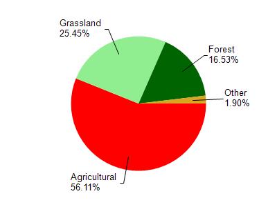
Rattlesnake Creek is located in the Lower Grant River watershed which is 129.75 mi². Land use in the watershed is primarily agricultural (56%), grassland (25.40%) and a mix of forest (16.50%) and other uses (1.90%). This watershed has 310.53 stream miles, 33.46 lake acres and 298.95 wetland acres.
Nonpoint Source Characteristics
This watershed is ranked Not Ranked for runoff impacts on streams, Not Available for runoff impacts on lakes and High for runoff impacts on groundwater and therefore has an overall rank of High. This value can be used in ranking the watershed or individual waterbodies for grant funding under state and county programs.However, all waters are affected by diffuse pollutant sources regardless of initial water quality. Applications for specific runoff projects under state or county grant programs may be pursued. For more information, go to surface water program grants.