")
9.36 Miles
0 - 9.36
Cool-Cold Mainstem, Coldwater
2025
Fair
Portage
Yes
No
No
Fish and Aquatic Life
Overview
Fourmile Creek is a 20-mile tributary to the Wisconsin River. The stream is impounded at two locations creating Wazeecha and Nepco Lakes. The upper 11 miles of the stream have been ditched and is now called Ditch No. 4. The lower eight miles supports a warm water sport fishery and the upper 12 miles including Ditch No. 4 are classified as Class I trout water. Cattle pasturing, streambank erosion, sedimentation and the lack of pools, riffles and fish cover impact the habitat of the non-ditched portion of the stream.
Ditch No. 4 has higher densities of brook trout than the lower reaches known as Fourmile Creek. Land use surrounding the ditch is dominated by cranberry marshes, irrigated cropland and state owned prairie chicken land. Limiting factors of in-stream habitat include channel ditching, sedimentation primarily from wind erosion, and the lack of pools and riffles. Overhanging vegetation, submerged macrophytes and some undercutting of the streambanks provides fish cover. Three of the cranberry operations utilize ditch water for cultivating cranberries. Continuous temperature monitoring found higher water temperatures in the ditch below the discharges of the marshes. Streamflow monitoring was completed in 1997 above and below these marshes during the fall harvest. During this time, streamflow decreased below these marshes by 60%. The water drawn from a ditch impacts in-stream habitat by reducing stream depth, decreasing the amount of fish cover and may increase water temperatures. Water removed from the ditches during the fall harvest reduces water levels and may impact(s) the spawning success of trout. The reduction of water levels can reduce spawning areas and may expose fish redds causing mortality of eggs or larval fish.
The steep grade in the lower portion of Fourmile Creek, below CTH F, has led to streambank and streambed erosion. It is believed 65 to 75 percent of the sediment entering Lake Wazeecha is from Lower Fourmile Creek (Kruger). High concentrations of phosphorus are found in the sediment. Grade control (drop) structures and riprap are possible means for controlling bed load sediment movement and streambank erosion.
The Upper Fourmile Creek Watershed is a source of nutrients in the creek and lake. In-stream nitrate values as high as 4.5 ppm have been detected. The nutrients come from wetland drainage, wind erosion and streambank pasturing. Lower gradients permit sediments to settle out and not constitute a large percentage of the total Fourmile Creek sediment reaching Lake Wazeecha (Kruger, 1986).
Date 2002
Author Aquatic Biologist
General Condition
Fourmile Creek (WBIC 1389600) from the control structure in SE1/4 S33 T22N R8E to the headwaters was assessed during the 2018 listing cycle; new biological (fish Index of Biotic Integrity (IBI) scores) and temperature sample data were clearly below the 2018 WisCALM listing thresholds for the Fish and Aquatic Life use. This water was meeting this designated use and was not considered impaired.
Date 2017
Author Ashley Beranek
Condition
Wisconsin has over 84,000 miles of streams, 15,000 lakes and milllions of acres of wetlands. Assessing the condition of this vast amount of water is challenging. The state's water monitoring program uses a media-based, cross-program approach to analyze water condition. An updated monitoring strategy (2015-2020) is now available. Compliance with Clean Water Act fishable, swimmable standards are located in the Executive Summary of Water Condition in 2018. See also the 'monitoring and projects' tab.
Reports
Recommendations
Protect Riparian or Shorelands
Address the issue of WQ protection and development along Nepco Lake and the Four-mile Creek. SSA Plan Committee agreed to extend the proposed area after counseling with the Village of Port Edwards.
Action Migrated from WATERS
Watershed staff, in cooperation with Portage County Land Conservation Department and Central Wisconsin Windshed Partnership, should continue to work with local farmers to encourage wind erosion best management practices.
Management Goals
Wisconsin's Water Quality Standards provide qualitative and quantitative goals for waters that are protective of Fishable, Swimmable conditions [Learn more]. Waters that do not meet water quality standards are considered impaired and restoration actions are planned and carried out until the water is once again fishable and swimmable
Management goals can include creation or implementation of a Total Maximum Daily Load analysis, a Nine Key Element Plan, or other restoration work, education and outreach and more. If specific recommendations exist for this water, they will be displayed below online.
Monitoring
Monitoring the condition of a river, stream, or lake includes gathering physical, chemical, biological, and habitat data. Comprehensive studies often gather all these parameters in great detail, while lighter assessment events will involve sampling physical, chemical and biological data such as macroinvertebrates. Aquatic macroinvertebrates and fish communities integrate watershed or catchment condition, providing great insight into overall ecosystem health. Chemical and habitat parameters tell researchers more about human induced problems including contaminated runoff, point source dischargers, or habitat issues that foster or limit the potential of aquatic communities to thrive in a given area. Wisconsin's Water Monitoring Strategy was recenty updated.
Grants and Management Projects
Monitoring Projects
| WBIC | Official Waterbody Name | Station ID | Station Name | Earliest Fieldwork Date | Latest Fieldwork Date | View Station | View Data |
|---|
| 1389600 | Fourmile Creek | 10034661 | Fourmile Creek (Ditch No. 4) at Griffith Ave. | 10/10/2011 | 1/1/2015 | Map | Data |
| 1389600 | Fourmile Creek | 10016336 | Ditch No. 4 - 100 Yards Downstream Cranberrymarsh Driveway Downstream Marshes | 10/20/1997 | 10/20/1997 | Map | Data |
| 1389600 | Fourmile Creek | 10033581 | Fourmile Creek (Ditch 4) at Cty. Tr. F | | | Map | Data |
| 1389600 | Fourmile Creek | 10033570 | FourMile Creek (Ditch Four) at 130th St. | | | Map | Data |
| 1389600 | Fourmile Creek | 10012968 | Fourmile Creek (at CTH W and driveway) | | | Map | Data |
| 1389600 | Fourmile Creek | 10044995 | Fourmile Creek at 95th St. | 11/14/2013 | 10/31/2025 | Map | Data |
| 1389600 | Fourmile Creek | 503143 | Ditch #4 - Ditch No 4 Of Hwy Ww - Uw10/Confluence Of Ditches 3 And 4 | | | Map | Data |
| 1389600 | Fourmile Creek | 10037581 | Fourmile Creek at 100th St | 6/13/2007 | 1/1/2015 | Map | Data |
| 1389600 | Fourmile Creek | 10033593 | Fourmile Creek (Ditch Four) at Townline Rd | 8/31/2023 | 8/31/2023 | Map | Data |
|
Watershed Characteristics
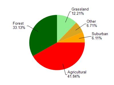
Fourmile Creek is located in the Fourmile and Fivemile Creek watershed which is 213.96 mi². Land use in the watershed is primarily agricultural (41.80%), forest (33.10%) and a mix of grassland (12.20%) and other uses (12.80%). This watershed has stream miles, lake acres and 13,528.97 wetland acres.
Nonpoint Source Characteristics
This watershed is ranked Medium for runoff impacts on streams, Medium for runoff impacts on lakes and High for runoff impacts on groundwater and therefore has an overall rank of High. This value can be used in ranking the watershed or individual waterbodies for grant funding under state and county programs.However, all waters are affected by diffuse pollutant sources regardless of initial water quality. Applications for specific runoff projects under state or county grant programs may be pursued. For more information, go to surface water program grants.
Ditch #4 is considered a Cool-Cold Mainstem, Coldwater under the state's Natural Community Determinations.
Natural communities (stream and lake natural communities) represent model results and DNR staff valiation processes that confirm or update predicted conditions based on flow and temperature modeling from historic and current landscape features and related variables. Predicated flow and temperatures for waters are associated predicated fish assemblages (communities). Biologists evaluate the model results against current survey data to determine if the modeled results are corect and whether biological indicators show water quaity degradation. This analysis is a core component of the state's resource management framework. Wisconsin's Riverine Natural Communities.
Cool (Cold-Transition) Mainstem streams are moderate-to-large but still wadeable perennial streams with cold to cool summer temperatures. Coldwater fishes are common to uncommon, transitional fishes are abundant to common, and warm water fishes are uncommon to absent. Headwater species are common to absent,
mainstem species are abundant to common, and river species are common to absent.