Iron
No
Yes
Yes
Fish and Aquatic Life
Overview
The North Fork of the Flambeau River is impounded in Iron County, forming the Flambeau Reservoir (Flowage), or Turtle-Flambeau Flowage. The flowage supplies water during low-flow periods. Land surrounding the Turtle-Flambeau Flowage is considered an exceptional wilderness recreational area. In 1990, the state purchased the land surrounding the flowage from Northern States Power Company and drafted a master plan for managing the waterbody.
Larson, Nancy and Lisa Kosmond (Helmuth). 1996. Upper Chippewa River Basin Water Quality Management Plan.
PUBL-WR-345-96-REV. Wisconsin Department of Natural Resources, Madison, WI.
Date 1996
Author Aquatic Biologist
Historical Description
Turtle-Flambeau Flowage is a soft water drainage lake (impoundment) having slightly alkaline, light brown water of low transparency. The principal inlet streams are the North Fork of the Flambeau River and the Turtle River, both of which are navigable. The outlet stream, North Fork of the Flambeau River, is navigable and tributary to the Flambeau River which is part of the Chippewa River drainage. Sand and gravel are the predominant littoral materials with significant areas of muck and rubble along with same boulders. The shoreline is predominantly upland, however, wetland shoreline is significant as 6,366 acres of wetland adjoin the lake basin. Walleye, northern pike, muskellunge, largemouth bass, smallmouth bass, lake sturgeon, cisco, crappie, perch, bluegill, pumpkinseed, rock bass, bullhead, redhorse, suckers and other forage fishes inhabit this lake. Waterfowl utilize this lake on their spring and fall migrations and for nesting. Canada, blue and snow geese and on occasion swans also use this area. Furbearers are found in the shore areas. Aquatic vegetation is sparse throughout most of the basin. There are 60 dwellings and 24 resorts located on the shoreline. Public access with parking is available at four locations including several landings maintained by the Chippewa-Flambeau Improvement Company. Iron County maintains a small park and campground (15 units) just below Lake of the Falls and a private campground (20 units) is located on the northwest shore. In addition, the Flambeau Paper Company and Chippewa Flambeau Improvement Company have provided 25 wilderness campsites on the islands in the flowage for use by the public. About 3.8 miles of the shoreline is in public ownership, most of which is administered by the Division of Trust Lands and Investments. The dam that maintains this flowage has a head of 27 feet and is awned by the Chippewa-Flambeau Improvement Company. The creation of this flowage inundated at least 12 named lakes. It is in one of these former lake basins that the deepest part of the flowage is found, that being the Baraboo Lake basin at a known depth of 50 feet. The other former lake basins and their known depths are as follows: Bastine - 43 feet, Blair - 34 feet, Horseshoe - 28 feet, Landing - 21 feet, Lake Ten - 25 feet, Merkle - 44 feet, Mud - 21 feet, Rat - 27 feet, Sweeny - 28 feet, Townline - 25 feet and Turtle - 42 feet.
Source:1970, Surface Water Resources of Iron County,WI:WI-DNR Turtle-Flambeau Flowage, T42N, R2E, Section 34 Surface Acres = 13,545, S.D.F. = 12.94, Maximum Depth = 50 feet.
Date 1970
Author Aquatic Biologist
Impaired Waters
Turtle-Flambeau Flowage (WBIC 2294900) was placed on the impaired waters list for Mercury in 2002 and for total phosphorus in 2014. This water was assessed during the 2018 listing cycle; new total phosphorus sample data overwhelmingly exceeded the 2018 WisCALM listing thresholds for the Recreation use and Fish and Aquatic Life use. Chlorophyll-a sample data also exceeded both thresholds. Based on the most updated information the impairments of Excess Algal Growth and Eutrophication were added to the Total Phosphorus listing.
Date 2017
Author Ashley Beranek
Impaired Waters
Turtle-Flambeau Flowage (2294900) was placed on the impaired waters list for Mercury in 2002 and for total phosphorus in 2014. The 2016 assessments showed continued impairment by phosphorus; total phosphorus sample data overwhelmingly exceed 2016 WisCALM listing thresholds for the Recreation use and Fish and Aquatic Life use. Based on the most updated information, no change in existing impaired waters listing is needed.
Date 2015
Author Aaron Larson
Condition
Wisconsin has over 84,000 miles of streams, 15,000 lakes and milllions of acres of wetlands. Assessing the condition of this vast amount of water is challenging. The state's water monitoring program uses a media-based, cross-program approach to analyze water condition. An updated monitoring strategy (2015-2020) is now available. Compliance with Clean Water Act fishable, swimmable standards are located in the Executive Summary of Water Condition in 2018. See also the 'monitoring and projects' tab.
Reports
Recommendations
Water Quality Planning
The Flambeau Flowage Watershed is located primarily in Iron County with smaller sections in northwest Vilas County and northern Price County. It has an area of 247 square miles. This watershed plan was completed by 2011.
Management Goals
Wisconsin's Water Quality Standards provide qualitative and quantitative goals for waters that are protective of Fishable, Swimmable conditions [Learn more]. Waters that do not meet water quality standards are considered impaired and restoration actions are planned and carried out until the water is once again fishable and swimmable
Management goals can include creation or implementation of a Total Maximum Daily Load analysis, a Nine Key Element Plan, or other restoration work, education and outreach and more. If specific recommendations exist for this water, they will be displayed below online.
Monitoring
Monitoring the condition of a river, stream, or lake includes gathering physical, chemical, biological, and habitat data. Comprehensive studies often gather all these parameters in great detail, while lighter assessment events will involve sampling physical, chemical and biological data such as macroinvertebrates. Aquatic macroinvertebrates and fish communities integrate watershed or catchment condition, providing great insight into overall ecosystem health. Chemical and habitat parameters tell researchers more about human induced problems including contaminated runoff, point source dischargers, or habitat issues that foster or limit the potential of aquatic communities to thrive in a given area. Wisconsin's Water Monitoring Strategy was recenty updated.
Grants and Management Projects
Monitoring Projects
| WBIC | Official Waterbody Name | Station ID | Station Name | Earliest Fieldwork Date | Latest Fieldwork Date | View Station | View Data |
|---|
| 2294900 | Turtle Flambeau Flowage | 263133 | Turtle Flambeau Flowage at Grant Creek Confluence | 6/28/1999 | 11/11/2001 | Map | Data |
| 2294900 | Turtle Flambeau Flowage | 10047853 | Turtle Flambeau Flowage | 7/28/2015 | 7/19/2023 | Map | Data |
| 2294900 | Turtle Flambeau Flowage | 263049 | Turtle Flambeau Flowage - Lake Bastine - Deep Hole | 5/4/1998 | 10/23/2023 | Map | Data |
| 2294900 | Turtle Flambeau Flowage | 10039042 | Turtle Flambeau Flowage- East of Fishermans Landing Area | | | Map | Data |
| 2294900 | Turtle Flambeau Flowage | 263132 | Turtle Flambeau Flowage - Downstream Of Murry Rd | 6/28/1999 | 11/11/2001 | Map | Data |
| 2294900 | Turtle Flambeau Flowage | 263137 | Turtle Flambeau Flowage - By Turtle Dam (Site #8) | 10/23/1998 | 11/12/2001 | Map | Data |
| 2294900 | Turtle Flambeau Flowage | 10039861 | Turtle Flambeau Flowage- Flambeau River | | | Map | Data |
| 2294900 | Turtle Flambeau Flowage | 263122 | Flambeau Flowage - Deep Hole | | | Map | Data |
| 2294900 | Turtle Flambeau Flowage | 10039829 | Turtle Flambeau Flowage- Lake Ten | | | Map | Data |
| 2294900 | Turtle Flambeau Flowage | 263162 | Spider Lake - Deep Hole | | | Map | Data |
| 2294900 | Turtle Flambeau Flowage | 10019469 | Turtle Flambeau Flowage -- Fishermans Landing Access | 8/21/2004 | 8/11/2023 | Map | Data |
| 2294900 | Turtle Flambeau Flowage | 10020043 | Turtle Flambeau Flowage -- Sportsmans Landing Access | 7/14/2010 | 7/15/2022 | Map | Data |
| 2294900 | Turtle Flambeau Flowage | 10037948 | Turtle Flambeau Flowage - Murray's Landing Access | 6/16/2010 | 6/19/2023 | Map | Data |
| 2294900 | Turtle Flambeau Flowage | 263048 | Turtle Flambeau Flowage - Big Water | 5/4/1998 | 8/28/2023 | Map | Data |
| 2294900 | Turtle Flambeau Flowage | 153 | Flambeau River Flowage - Flambeau River Flow | | | Map | Data |
| 2294900 | Turtle Flambeau Flowage | 10019764 | Turtle Flambeau Flowage - Near Murrays Landing | 5/8/2011 | 8/20/2023 | Map | Data |
| 2294900 | Turtle Flambeau Flowage | 10039040 | Turtle Flambeau Flowage- Bonies Mound Area | | | Map | Data |
| 2294900 | Turtle Flambeau Flowage | 263059 | Turtle Flambeau Flowage - Baraboo - Deep Hole | 10/22/1998 | 8/23/2023 | Map | Data |
| 2294900 | Turtle Flambeau Flowage | 264025 | Flambeau Flowage - Flambeau Flowage | | | Map | Data |
| 2294900 | Turtle Flambeau Flowage | 263050 | Turtle Flambeau Flowage - Townline Lake - Deep Hole | 5/4/1998 | 8/26/2023 | Map | Data |
| 2294900 | Turtle Flambeau Flowage | 10020041 | Turtle Flambeau Flowage -- Springstead Landing Access | 9/3/2004 | 8/4/2023 | Map | Data |
| 2294900 | Turtle Flambeau Flowage | 263051 | Turtle Flambeau Flowage - E Basin | 5/4/1998 | 9/19/1998 | Map | Data |
| 2294900 | Turtle Flambeau Flowage | 10019470 | Turtle Flambeau Flowage -- Sturgeon Bay Landing Access | 8/20/2006 | 8/11/2023 | Map | Data |
| 2294900 | Turtle Flambeau Flowage | 10044518 | TURTLE FLAMBEAU FLOWAGE- LAKE BASTINE | | | Map | Data |
| 2294900 | Turtle Flambeau Flowage | 263135 | Turtle Flambeau Flowage - By Norway Point (Site #6) | 7/28/1999 | 11/11/2001 | Map | Data |
| 2294900 | Turtle Flambeau Flowage | 263182 | Turtle Flambeau Flowage - Turtle Inlet | 7/3/2006 | 4/14/2024 | Map | Data |
| 2294900 | Turtle Flambeau Flowage | 263136 | Turtle Flambeau Flowage - By Bastine Road (Site #7) | 7/28/1999 | 7/3/2002 | Map | Data |
| 2294900 | Turtle Flambeau Flowage | 10039828 | Turtle Flambeau Flowage- Sturgeon Bay | | | Map | Data |
| 2294900 | Turtle Flambeau Flowage | 10048155 | TURTLE FLAMBEAU FLOWAGE- HORSESHOE | | | Map | Data |
| 2294900 | Turtle Flambeau Flowage | 10002830 | Turtle-Flambeau Flowage | 8/29/2000 | 7/19/2023 | Map | Data |
| 2294900 | Turtle Flambeau Flowage | 263131 | Turtle Flambeau Flowage - Upstream Of Murry Rd | 6/28/1999 | 11/11/2000 | Map | Data |
| 2294900 | Turtle Flambeau Flowage | 10039791 | Turtle Flambeau Flowage- Grassy Island | | | Map | Data |
| 2294900 | Turtle Flambeau Flowage | 10040855 | Lake Bastine Deep Hole near Mercer WI | 4/29/2009 | 3/15/2010 | Map | Data |
| 2294900 | Turtle Flambeau Flowage | 10044519 | TURTLE FLAMBEAU FLOWAGE- MERKLE LAKE | | | Map | Data |
| 2294900 | Turtle Flambeau Flowage | 10039041 | Turtle Flambeau Flowage- Baraboo Lake Area | | | Map | Data |
| 2294900 | Turtle Flambeau Flowage | 263134 | Turtle Flambeau Flowage - By Townline Rd (Site #5) | 10/22/1998 | 6/2/2004 | Map | Data |
| 2294900 | Turtle Flambeau Flowage | 10031212 | Turtle Flambeau Flowage at Lake Bastine (Deep Hole) | | | Map | Data |
|
Watershed Characteristics
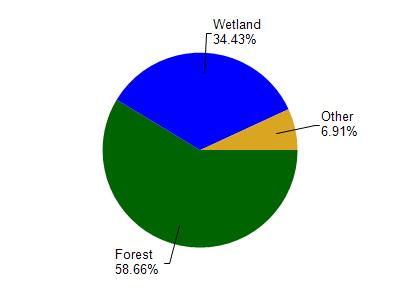
Turtle Flambeau Flowage is located in the Upper North Fork Flambeau River watershed which is 158.21 mi². Land use in the watershed is primarily forest (58.60%), wetland (34.40%) and a mix of grassland (2.90%) and other uses (4.00%). This watershed has 163.80 stream miles, 629.65 lake acres and 33,475.50 wetland acres.
Nonpoint Source Characteristics
This watershed is ranked Low for runoff impacts on streams, Low for runoff impacts on lakes and Low for runoff impacts on groundwater and therefore has an overall rank of Low. This value can be used in ranking the watershed or individual waterbodies for grant funding under state and county programs.However, all waters are affected by diffuse pollutant sources regardless of initial water quality. Applications for specific runoff projects under state or county grant programs may be pursued. For more information, go to surface water program grants.