Richland, Sauk
Yes
No
No
Fish and Aquatic Life
Overview
Willow Creek is a spring and drainage fed stream that enters the Pine River. The stream is
classified as an exceptional resource water (ERW) from above the Ithaca dam upstream to the
Richland-Sauk county line, a distance of about 16.9 miles. Downstream of the Ithaca dam the
stream is a warm water sport fishery. The stream supports the natural reproduction of brook
and brown trout and is considered a Class I trout stream above the Ithaca Dam. Baseline
monitoring was conducted in 2000 and it is recommended that the trout stream portion of
Willow Creek be increased to 21.8 miles of Class I trout water. There are a number of cattle
feedlots on or near the stream which might be affecting habitat and water quality and
sedimentation is a problem in some areas of the stream. The creek is a high priority for
nonpoint source pollution reduction. Habitat in the area surveyed is good although there are
some areas of the stream that could use some habitat work. Overall, water quality is generally
thought to be good.
From: Ripp, Coreen, Koperski, Cindy and Folstad, Jason. 2002. The State of the Lower Wisconsin River Basin. PUBL WT-559-2002. Wisconsin Department of Natural Resources, Madison, WI.
Date 2002
Author Cynthia Koperski
Historical Description
Willow Creek is classified ERW from above the Ithaca dam upstream to the Richland-
Sauk county line, a distance of about 16.9 miles. Downstreanl of the Ithaca dam the
stream is a warm water sport fishery stream. The stream has 12.5 miles of Class I trout
waters and 5.7 miles of Class II trout water (WDNR, 1980). Water quality is generally
thought to be good (Eagan, 1980). There are a number of cattle feed lots on or near the
stream which are thought to be affecting habitat and water quality (WDNR, Kerr,
1991). Trout populations in the reach just below Loyd have drastically declined
since a high in 1986 (WDNR, Kerr, 1991). Habitat in the area surveyed is good.
Sedimentation is a problem in some areas of the stream (WDNR, 1991).
Date 1994
Author Surface Water Inventory Of Wisconsin
General Condition
Willow Creek (WBIC 1220900) segment from Ithaca Dam to Hwy D was assessed during the 2018 listing cycle; new biological (fish Index of Biotic Integrity (IBI) scores) sample data were clearly below the 2018 WisCALM listing thresholds for the Fish and Aquatic Life use. This water was meeting this designated use and was not considered impaired.
Date 2017
Author Ashley Beranek
Condition
Wisconsin has over 84,000 miles of streams, 15,000 lakes and milllions of acres of wetlands. Assessing the condition of this vast amount of water is challenging. The state's water monitoring program uses a media-based, cross-program approach to analyze water condition. An updated monitoring strategy (2015-2020) is now available. Compliance with Clean Water Act fishable, swimmable standards are located in the Executive Summary of Water Condition in 2018. See also the 'monitoring and projects' tab.
Reports
Recommendations
Watershed Mapping or Assessment
The Conservancy will develop a site conservation plan to guide them and other project partners with specific goals for the permanent protection, restoration and enhancements of important conservation projects. A full description of the project goals, objectives, and activities are in the grant application narrative, which is a part of this contract.
Management Goals
Wisconsin's Water Quality Standards provide qualitative and quantitative goals for waters that are protective of Fishable, Swimmable conditions [Learn more]. Waters that do not meet water quality standards are considered impaired and restoration actions are planned and carried out until the water is once again fishable and swimmable
Management goals can include creation or implementation of a Total Maximum Daily Load analysis, a Nine Key Element Plan, or other restoration work, education and outreach and more. If specific recommendations exist for this water, they will be displayed below online.
Monitoring
Monitoring the condition of a river, stream, or lake includes gathering physical, chemical, biological, and habitat data. Comprehensive studies often gather all these parameters in great detail, while lighter assessment events will involve sampling physical, chemical and biological data such as macroinvertebrates. Aquatic macroinvertebrates and fish communities integrate watershed or catchment condition, providing great insight into overall ecosystem health. Chemical and habitat parameters tell researchers more about human induced problems including contaminated runoff, point source dischargers, or habitat issues that foster or limit the potential of aquatic communities to thrive in a given area. Wisconsin's Water Monitoring Strategy was recenty updated.
Grants and Management Projects
Monitoring Projects
| WBIC | Official Waterbody Name | Station ID | Station Name | Earliest Fieldwork Date | Latest Fieldwork Date | View Station | View Data |
|---|
| 1220900 | Willow Creek | 10030058 | Upper Willow Creek along Harris Rd St. #8 | 1/1/2015 | 1/1/2015 | Map | Data |
| 1220900 | Willow Creek | 10030056 | Willow Creek DS confluence of unnamed trib (WBIC 5031275) | 1/1/2015 | 1/1/2015 | Map | Data |
|
Watershed Characteristics
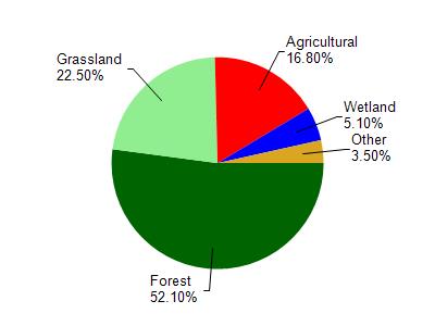
Willow Creek is located in the Willow Creek watershed which is 153.08 mi². Land use in the watershed is primarily forest (52.10%), grassland (22.50%) and a mix of agricultural (16.80%) and other uses (8.60%). This watershed has 339.41 stream miles, 64.58 lake acres and 3,605.43 wetland acres.
Nonpoint Source Characteristics
This watershed is ranked High for runoff impacts on streams, Low for runoff impacts on lakes and High for runoff impacts on groundwater and therefore has an overall rank of High. This value can be used in ranking the watershed or individual waterbodies for grant funding under state and county programs.However, all waters are affected by diffuse pollutant sources regardless of initial water quality. Applications for specific runoff projects under state or county grant programs may be pursued. For more information, go to surface water program grants.