Dunn
No
No
No
Fish and Aquatic Life
Overview
Eau Gale Lake is a 150-acre flood control impoundment on the Eau Galle River near Spring
Valley. The Army Corps of Engineers Waterways Experiment Station has intensively monitored
this aquatic ecosystem since 1981. The reservoir receives large amounts of nutrients and sediments
from its agricultural watershed. The reservoir experiences frequent summer algal blooms and
extensive aquatic plant growth in shallow areas. The control of sediment, nutrients and storm
water runoff is critical if water quality is to be improved in the reservoir (Barko; James)
Fish from Lake Eau Galle at Spring Valley were tested for mercury. All fish were below the
mercury advisory criteria. Additional fish should be sampled for the presence of PCBs (Amrhein).
Date 1996
Author Aquatic Biologist
Overview
The operation of a hydropower plant at the dam in Eau Galle causes significant daily flow
fluctuation in violation of federal requirements. Attempts by the operator to bring the facility into
compliance have not been totally successful. The fluctuations affect aquatic habitat and may affect
water quality as well. WDNR continues to work with the Federal Energy Regulatory Commission
(FERC) to bring the facility into compliance (LaLiberte).
Fish from Lake Eau Galle at Eau Galle were tested for mercury. All fish were below the mercury
advisory criteria, but need to be assessed for the presence of PCBs (Amrhein).
WDNR has very little water quality data for this lake. A lakes planning grant would be useful for
developing a management plan and conducting a land use assessment.
Date 1996
Author Aquatic Biologist
Historical Description
Source: 1962, Surface Water Resources of Dunn County
Eau Galle 2-16 T26N, R14W, Sec. 2
Surface Acres = 1.0, S.D.F. = 1.29, Maximum Depth = 5 feet
A hardwater, seepage lake, landlocked and having no manageable fish
population due to winterkill conditions. Public frontage, private
development and wetlands are also lacking. A few migrant ducks may be
found here.
Lake Eau Galle T26N, R13, 14W, Sec. 19, 30, 31, 24, 25, 36
Surface Acres = 343.2, S. D. F. = 2.81, Maximum Depth = 22 feet
A hardwater, drainage impoundment on the Eau Galle River. It has a
navigable inlet and a 30-foot head public utility dam (Wisconsin
Hydro-Electric Company, Northern States Power) on its outlet (67 cfs).
Hay Creek of Eau Galle Township also empties into the flowage. It is
managed for largemouth bass and pan fish. The pan fish group includes
bluegills, black crappies, white crappies, perch, white bass, black and
brown bullheads. Rough fish species include white suckers, carp,
northern and golden redhorse. The carp are a problem in the management
of this flowage. Public frontage consists of a park and access road
developed by the Eau Galle Sportsmen's Club. Private development
includes two resorts, three boat liveries and ten cottages. A small
wetland area of about two acres provides habitat for muskrats and nesting
blue-winged teal and wood ducks.
Date 1962
Author Surface Water Inventory Of Wisconsin
Condition
Wisconsin has over 84,000 miles of streams, 15,000 lakes and milllions of acres of wetlands. Assessing the condition of this vast amount of water is challenging. The state's water monitoring program uses a media-based, cross-program approach to analyze water condition. An updated monitoring strategy (2015-2020) is now available. Compliance with Clean Water Act fishable, swimmable standards are located in the Executive Summary of Water Condition in 2018. See also the 'monitoring and projects' tab.
Reports
Management Goals
Wisconsin's Water Quality Standards provide qualitative and quantitative goals for waters that are protective of Fishable, Swimmable conditions [Learn more]. Waters that do not meet water quality standards are considered impaired and restoration actions are planned and carried out until the water is once again fishable and swimmable
Management goals can include creation or implementation of a Total Maximum Daily Load analysis, a Nine Key Element Plan, or other restoration work, education and outreach and more. If specific recommendations exist for this water, they will be displayed below online.
Monitoring
Monitoring the condition of a river, stream, or lake includes gathering physical, chemical, biological, and habitat data. Comprehensive studies often gather all these parameters in great detail, while lighter assessment events will involve sampling physical, chemical and biological data such as macroinvertebrates. Aquatic macroinvertebrates and fish communities integrate watershed or catchment condition, providing great insight into overall ecosystem health. Chemical and habitat parameters tell researchers more about human induced problems including contaminated runoff, point source dischargers, or habitat issues that foster or limit the potential of aquatic communities to thrive in a given area. Wisconsin's Water Monitoring Strategy was recenty updated.
Grants and Management Projects
Monitoring Projects
| WBIC | Official Waterbody Name | Station ID | Station Name | Earliest Fieldwork Date | Latest Fieldwork Date | View Station | View Data |
|---|
| 2056600 | Lake Eau Galle | 10018207 | Lake Eau Galle -- Pine Point County Park | 8/6/2008 | 7/24/2024 | Map | Data |
| 2056600 | Lake Eau Galle | 10002315 | Lake Eau Galle | 10/22/1991 | 7/24/2024 | Map | Data |
| 2056600 | Lake Eau Galle | 173224 | Lake Eau Galle - Middle Of Lake | 5/2/1995 | 9/13/2025 | Map | Data |
| 2056600 | Lake Eau Galle | 173044 | Eau Galle River - Above Dam R.Mi-8.0 | 4/23/1998 | 10/28/2002 | Map | Data |
| 2056600 | Lake Eau Galle | 173043 | Lower Pine Creek - Twn Rd.R.Mi-2.9 | | | Map | Data |
| 2055000 | Eau Galle River | 173042 | Eau Galle River - Boatlanding R.Mi-8.2 | | | Map | Data |
| 2056600 | Lake Eau Galle | 10018222 | Lake Eau Galle -- Access Sites | 9/7/2009 | 7/24/2024 | Map | Data |
| 2056600 | Lake Eau Galle | 10056280 | Lake Eau Galle - Center of Lake | | | Map | Data |
|
Watershed Characteristics
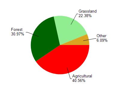
Lake Eau Galle is located in the Eau Galle River watershed which is 267.88 mi². Land use in the watershed is primarily agricultural (40.60%), forest (31%) and a mix of grassland (22.40%) and other uses (6.10%). This watershed has 519.34 stream miles, 251.50 lake acres and 3,943.12 wetland acres.
Nonpoint Source Characteristics
This watershed is ranked High for runoff impacts on streams, Not Ranked for runoff impacts on lakes and High for runoff impacts on groundwater and therefore has an overall rank of High. This value can be used in ranking the watershed or individual waterbodies for grant funding under state and county programs.However, all waters are affected by diffuse pollutant sources regardless of initial water quality. Applications for specific runoff projects under state or county grant programs may be pursued. For more information, go to surface water program grants.