Barron
No
No
No
Fish and Aquatic Life
Overview
The Dummy lakes are seepage lakes about two miles northeast of Cumberland. The 11 1-acre Big Dummy Lake consists of two distinct basins. The east basin contains a conical depression with a maximum depth of 54 feet. The west basin is flat, shallow, muck-bottomed and subject to dense growths of rooted aquatic plants. The south and west shores of Big Dummy Lake are ringed with a fringe of wetland shoreline. Little Dummy Lake spans 3 1 acres, has a maximum depth of 44 feet and a substantial amount of wetland shoreline bordering the north and south ends. An excavated non-navigable channel connects the two lakes.
The Dummy Lakes Management District was formed in 1981 and applied for assistance in 1982 to design a feasibility study under the lake management program of the WDNR's Office of Inland Lake Renewal. The feasibility study was not implemented and the Office of Inland Lake Renewal and its programs were eliminated shortly thereafter.
Water quality data was collected on the lakes during the water quality assessment period for the Yellow River Priority Watershed Project. This data, plus Secchi disk information collected by self-help volunteers suggests high water quality in these lakes. Trophic state index values of 49 for Big Dummy Lake and 48 for Little Dummy Lake have been documented. Despite the good water quality as reflected by the TSI values, portions of these lakes are prone to dense growths of rooted aquatic vegetation. These weed beds may be primarily due to physical habitat features rather than trophic responses to accelerated nutrient loading. The residents of the Dummy Lakes Management District have employed mechanical aquatic vegetation cutter-harvesters to enable recreational uses of these heavily vegetated areas. The Dummy Lakes should receive a high priority for a lake management planning grant and the lake management organization assisted in applying for such a grant to continue working to complete a comprehensive lake management plan.
Date 1996
Author Aquatic Biologist
Historical Description
Source: 1964, Surface Water Resources of Barron County Little Dummy Lake T36N, R13W, Section 28 Surface Acres = 30.9, S.D.F. =1.32, Maximum Depth = 44 feet.
A soft water seepage lake, landlocked and having a fish population of northern pike, largemouth bass, bluegills, bullheads, white suckers and carp. Upland hardwoods surround the lake with the exception of a 17-acre marshy wetland bordering the north and south ends. The wetland provides habitat for muskrats, nesting mallards and wood ducks. There is no public access to the lake; however, there is a private landing at the north end. About 0.33 miles of Conservation Department frontage on the southwest side is public frontage. This land was purchased as part of the remnant warm water fish habitat project. Private development consists of one farm home.
Date 1964
Author Surface Water Inventory Of Wisconsin
General Condition
Little Dummy Lake (WBIC 1861400) was placed on the impaired waters list for total phosphorus in 2016. This lake was evaluated in the 2022 cycle for phosphorus and levels were below criteria; the lake was delisted in the 2022 cycle and is on the Healthy Waters List.
Date 2022
Author Ashley Beranek
Impaired Waters
Little Dummy Lake (WBIC 1861400) was placed on the impaired waters list for total phosphorus in 2016. This lake was assessed during the 2018 listing cycle; new chlorophyll sample data were clearly below 2018 WisCALM listing thresholds for the Recreation use and the Fish and Aquatic Life use. Total Phosphorus sample data were not clearly below listing thresholds. Based on the most updated information, no change in existing impaired waters listing was needed.
Date 2017
Author Ashley Beranek
Impaired Waters
This water was assessed during the 2016 listing cycle; total phosphorus sample data exceed 2016 WisCALM listing thresholds for the Recreation use, however, chlorophyll data do not exceed REC thresholds. Total phosphorus and chlorophyll data do not exceed Fish and Aquatic Life thresholds.
Date 2015
Author Aaron Larson
Condition
Wisconsin has over 84,000 miles of streams, 15,000 lakes and milllions of acres of wetlands. Assessing the condition of this vast amount of water is challenging. The state's water monitoring program uses a media-based, cross-program approach to analyze water condition. An updated monitoring strategy (2015-2020) is now available. Compliance with Clean Water Act fishable, swimmable standards are located in the Executive Summary of Water Condition in 2018. See also the 'monitoring and projects' tab.
Reports
Management Goals
Wisconsin's Water Quality Standards provide qualitative and quantitative goals for waters that are protective of Fishable, Swimmable conditions [Learn more]. Waters that do not meet water quality standards are considered impaired and restoration actions are planned and carried out until the water is once again fishable and swimmable
Management goals can include creation or implementation of a Total Maximum Daily Load analysis, a Nine Key Element Plan, or other restoration work, education and outreach and more. If specific recommendations exist for this water, they will be displayed below online.
Monitoring
Monitoring the condition of a river, stream, or lake includes gathering physical, chemical, biological, and habitat data. Comprehensive studies often gather all these parameters in great detail, while lighter assessment events will involve sampling physical, chemical and biological data such as macroinvertebrates. Aquatic macroinvertebrates and fish communities integrate watershed or catchment condition, providing great insight into overall ecosystem health. Chemical and habitat parameters tell researchers more about human induced problems including contaminated runoff, point source dischargers, or habitat issues that foster or limit the potential of aquatic communities to thrive in a given area. Wisconsin's Water Monitoring Strategy was recenty updated.
Grants and Management Projects
Monitoring Projects
| WBIC | Official Waterbody Name | Station ID | Station Name | Earliest Fieldwork Date | Latest Fieldwork Date | View Station | View Data |
|---|
| 1861400 | Little Dummy Lake | 033184 | Little Dummy Lake - Deep Hole | 5/15/1988 | 8/23/2023 | Map | Data |
| 1861400 | Little Dummy Lake | 034005 | Little Dummy Lake - Deep Hole | 8/29/1979 | 8/29/1979 | Map | Data |
| 1861400 | Little Dummy Lake | 10000688 | Little Dummy Lake | 9/5/2000 | 10/3/2016 | Map | Data |
| 1861400 | Little Dummy Lake | 10019812 | Little Dummy Lake -- Access | 8/30/2007 | 8/30/2007 | Map | Data |
|
Watershed Characteristics
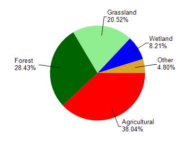
Little Dummy Lake is located in the Yellow River watershed which is 239.35 mi². Land use in the watershed is primarily agricultural (38%), forest (28.40%) and a mix of grassland (20.50%) and other uses (13.00%). This watershed has 415.31 stream miles, 2,929.80 lake acres and 11,565.29 wetland acres.
Nonpoint Source Characteristics
This watershed is ranked High for runoff impacts on streams, Not Available for runoff impacts on lakes and High for runoff impacts on groundwater and therefore has an overall rank of High. This value can be used in ranking the watershed or individual waterbodies for grant funding under state and county programs.However, all waters are affected by diffuse pollutant sources regardless of initial water quality. Applications for specific runoff projects under state or county grant programs may be pursued. For more information, go to surface water program grants.