Douglas
Yes
Yes
No
Fish and Aquatic Life
Overview
Downstream from County Highway B, this stream is considered a Class II trout fishery for resident brook, and migratory brown and rainbow trout. Blueberry Creek, a Class I trout stream, joins Nebagamon Creek before its confluence with the Bois Brule. Upstream reaches from its outlet at Nebagamon Lake down to Highway B mainly support warm water fish. A mixture of sand, gravel, boulder and rubble comprise the stream bottom and damaging flow extremes are a problem. The stream is identified as an outstanding resource water as part of the ABrule System@ designation in NR102.
The village of Lake Nebagamon discharges to groundwater in this watershed.
This stream has been identified in the coastal wetlands evaluation as a priority aquatic site. A rich macroinvertebrate fauna represented by 18 families is present and includes one globally rare dragonfly and two rare caddisflies. Low flow conditions were noted. Bank erosion was considered a significant source of pollution, at least at the sample site (Epstein 1997).
From: Turville-Heitz, Meg. 1999. Lake Superior Basin Water Quality Management Plan. Wisconsin Department of Natural Resources, Madison, WI.
Date 1999
Author Aquatic Biologist
Condition
Wisconsin has over 84,000 miles of streams, 15,000 lakes and milllions of acres of wetlands. Assessing the condition of this vast amount of water is challenging. The state's water monitoring program uses a media-based, cross-program approach to analyze water condition. An updated monitoring strategy (2015-2020) is now available. Compliance with Clean Water Act fishable, swimmable standards are located in the Executive Summary of Water Condition in 2018. See also the 'monitoring and projects' tab.
Reports
Recommendations
Best Management Practices, Implement
Partnering with property owners, the applicant is sponsoring a grant to implement water quality and habitat best practices from Wisconsin's Healthy Lakes Implementation Plan. Best practices, including fish sticks, 350 sq. ft. native plantings, diversions, rock infiltration, and/or rain gardens, will be designed and installed according to the Healthy Lakes fact sheets, technical guidance and grant application.
Stormwater Planning, Implementation
Village of Lake Nebagamon is sponsoring a project to implement engineered stormwater best practices at the lake's public boat landing downtown.
Management Goals
Wisconsin's Water Quality Standards provide qualitative and quantitative goals for waters that are protective of Fishable, Swimmable conditions [Learn more]. Waters that do not meet water quality standards are considered impaired and restoration actions are planned and carried out until the water is once again fishable and swimmable
Management goals can include creation or implementation of a Total Maximum Daily Load analysis, a Nine Key Element Plan, or other restoration work, education and outreach and more. If specific recommendations exist for this water, they will be displayed below online.
Monitoring
Monitoring the condition of a river, stream, or lake includes gathering physical, chemical, biological, and habitat data. Comprehensive studies often gather all these parameters in great detail, while lighter assessment events will involve sampling physical, chemical and biological data such as macroinvertebrates. Aquatic macroinvertebrates and fish communities integrate watershed or catchment condition, providing great insight into overall ecosystem health. Chemical and habitat parameters tell researchers more about human induced problems including contaminated runoff, point source dischargers, or habitat issues that foster or limit the potential of aquatic communities to thrive in a given area. Wisconsin's Water Monitoring Strategy was recenty updated.
Grants and Management Projects
| Project Name (Click for Details) | Year Started |
|---|
| NEBAGAMON LAKE ASSOCIATION, INC.: HLR - Healthy Lakes & Rivers - Nebagamon Nov. 2022 | 2023 |
| THE NEBAGAMON LAKE ASSOCIATION, INC.: The Nebagamon Lake Association, Inc. 2023 CBCW | 2023 |
| NEBAGAMON LAKE ASSOCIATION, INC.: AIS Education, Prevention, & Planning Project | 2007 |
| NEBAGAMON LAKE ASSOCIATION, INC.: Nebagamon Lake Association, Inc. 2017 CBCW | 2017 |
| VILLAGE OF LAKE NEBAGAMON: LMI-Stormwater Runoff Boat Landing Lake Nebagamon | 2017 |
| NEBAGAMON LAKE ASSOCIATION, INC.: Nebagamon Lake Association, Inc. 2018 CBCW | 2018 |
| NEBAGAMON LAKE ASSOCIATION, INC.: Lake Nebagamon AIS Control Project | 2006 |
| THE NEBAGAMON LAKE ASSOCIATION, INC.: The Nebagamon Lake Association, Inc. 2025 CBCW | 2025 |
| NEBAGAMON LAKE ASSOCIATION, INC.: Lake Nebagamon Clean Boats Clean Waters Project 2014 | 2014 |
| NEBAGAMON LAKE ASSOCIATION, INC.: HLR - Healthy Lakes & Rivers - Lake Nebagamon 2021 Application | 2022 |
| NEBAGAMON LAKE ASSOCIATION, INC.: Nebagamon Lake Association, Inc. 2020 CBCW | 2020 |
| NEBAGAMON LAKE ASSOCIATION, INC.: Nebagamon Lake Association, Inc. 2019 CBCW | 2019 |
| VILLAGE OF LAKE NEBAGAMON: Information Collection & Dissemination of Local Lake Zoning Regulations | 2004 |
| NEBAGAMON LAKE ASSOCIATION, INC.: Healthy Lakes Project Lake Nebagamon | 2018 |
| NEBAGAMON LAKE ASSOCIATION, INC.: HLK-Nebagamon HLK Initative 2020 | 2020 |
| THE NEBAGAMON LAKE ASSOCIATION, INC.: The Nebagamon Lake Association, Inc. 2022 CBCW | 2022 |
| NEBAGAMON LAKE ASSOCIATION, INC.: Lake Nebagamon 2015 Clean Boats Clean Waters Project | 2015 |
| NEBAGAMON LAKE ASSOCIATION, INC.: HLK-Lake Nebagamon Healthy Lakes Project | 2017 |
| THE NEBAGAMON LAKE ASSOCIATION, INC.: The Nebagamon Lake Association, Inc. 2024 CBCW | 2024 |
| Fish Propagation Actions | 2001 |
| NEBAGAMON LAKE ASSOCIATION, INC.: AIS Prevention - Clean Boats, Clean Waters | 2008 |
| NEBAGAMON LAKE ASSOCIATION, INC.: HLK-Healthy Lakes Initiative - Lake Nebagamon 2019 | 2019 |
| VILLAGE OF LAKE NEBAGAMON: RES - Lake Nebagamon Boat Launch Watershed Management | 2023 |
|
Monitoring Projects
| WBIC | Official Waterbody Name | Station ID | Station Name | Earliest Fieldwork Date | Latest Fieldwork Date | View Station | View Data |
|---|
| 2864200 | Nebagamon Creek | 163097 | Nebagamon Creek at Cth B | | | Map | Data |
| 2864200 | Nebagamon Creek | 10034873 | Nebagamon Cr. mouth of Blueberry Cr. upstream | | | Map | Data |
| 2864200 | Nebagamon Creek | 163108 | Nebagamon Creek at Old Rr Grd Sec29 | 9/17/1976 | 8/12/2019 | Map | Data |
| 2864200 | Nebagamon Creek | 10013415 | Nebagamon Creek- 15 Meters Upstream Hwy B- Station #2 | 1/1/2015 | 7/16/2021 | Map | Data |
| 2864200 | Nebagamon Creek | 163098 | Nebagamon Creek - End Of Tn Rd Sec 21 | 5/17/1977 | 5/17/1977 | Map | Data |
|
Watershed Characteristics
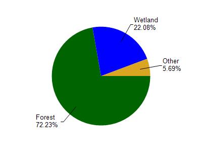
Nebagamon Creek is located in the Bois Brule River watershed which is 199.64 mi². Land use in the watershed is primarily forest (72.30%), wetland (22.10%) and a mix of grassland (3.40%) and other uses (2.30%). This watershed has 220.94 stream miles, 3,539.94 lake acres and 18,373.66 wetland acres.
Nonpoint Source Characteristics
This watershed is ranked Not Ranked for runoff impacts on streams, Not Available for runoff impacts on lakes and Low for runoff impacts on groundwater and therefore has an overall rank of Low. This value can be used in ranking the watershed or individual waterbodies for grant funding under state and county programs.However, all waters are affected by diffuse pollutant sources regardless of initial water quality. Applications for specific runoff projects under state or county grant programs may be pursued. For more information, go to surface water program grants.