Manitowoc
No
No
No
Fish and Aquatic Life
Overview
PIGEON LAKE
T18N, R22E, Section 33; Manitowoc County
Surface Acres = 77, S.D.F. = 1.32, Maximum Depth = 68 feet
Pigeon Lake is a 77-acre seepage lake located in southwestern Manitowoc County, Wisconsin. The lake has a maximum depth of 68 feet, an average depth of 35 feet and a single perennial outlet. The area is developed with residential dwellings and a recreational camp along the 1.6 miles of shoreline. The residences are served by sanitary sewer, which is treated at the Town of Liberty Wastewater Treatment Plant.
The fishery consist of largemouth bass, panfish, northern pike, and brown trout. Public access and parking is available by a town road (WDNR 1968).
Pigeon Lake has a 216 acre, primarily agricultural, watershed (Olson and Helsel 1997). Based upon the average annual run-off of 7.3 inches, the lake's flushing rate is .06 water volumes per year or about 17 years to flush the complete lake volume. The dominant land uses within the Pigeon Lake subwatershed are agriculture and forest. The estimated annual total phosphorus load to Pigeon Lake from the watershed and deposition is estimated at 133 lbs. Olson and Helsel (1997) found that, agriculture land use is estimated to contribute the greatest percentage of external phosphorus (48%) to the lake; while no other sources contribute more than 10% to the annual phosphorus load.
Water Resource Conditions
Pigeon Lake stratifies during the summer months during which the hypolimnion is anoxic (lack of oxygen in the bottom waters). Pigeon Lake is classified as a mesotrophic lake, with moderately clear water and relatively low nutrient and chlorophyll-a concentrations and good water clarity with TSI values between 45 and 55 (Figure 29).
Water quality samples collected during 1996 showed average spring total phosphorus ranged from 14 V 20 Ãg/L with surface summer phosphorus concentrations ranging from 11 - 15 Ãg/L. The hypolimnion develops anoxia (no oxygen), which results in higher phosphorus concentrations as phosphorus is released from the substrate. Generally hypolimnetic phosphorus concentrations above 200-300 Ãg/L are indicative of increased internal loading; although the hypolimnetic volume, lake morphology and stratification intensity also affect the amount of internal load (Olson and Helsel 1997).
Water Resource Objectives and Management Recommendations
The water resource objectives and management recommendations for Pigeon Lake are to reduce phosphorus loading overall by 47% from existing conditions (133 lbs/yr) to best managed conditions (70 lbs/yr ) (Olson and Helsel 1997). This should result in improvements in water column phosphorus and long-term protection of water quality.
Specific best management practices should target lake protection and nutrient sources from agricultural land and residential properties. Assessment of the internal loading should be continued by collection of in-lake water quality data.
Date 2001
Author Aquatic Biologist
Historical Description
Source: 1968, Surface Water Resources of Manitowoc County Pigeon Lake, T18N, R22E, Section 33 Surface acres - 77, S.D.F. = 1.32, Maximum depth = 67 feet.
A seepage lake in terminal moraine. This lake has hard, clear water and a bottom composed of marl and gravel. It is one of the most heavily used lakes in the county. An intermittent outlet drains the lake southward into Little Pigeon Lake during periods of high water. The lake is managed for largemouth bass, panfish, northern pike and brown trout. The shoreline is highly developed with 54 cottages, one resort and one Boy Scout camp. Swimming, water skiing and power boating conflict with daytime fishing, and tend to discourage usage by most wildlife. Public access and parking is available by a town road. There is about 100 feet of public frontage including boat launching facilities. One boat rental establishment increases fishing access. Blue-wing teal and wood ducks have been observed to nest here in few numbers, and moderate numbers of migrant waterfowl frequent the area in the fall. Hunting is permitted, except near the Boy Scout camp which is a wildlife refuge.
Date 1968
Author Surface Water Inventory Of Wisconsin
Impaired Waters
Pigeon Lake (64000) was placed on the impaired waters list for Mercury in fish tissue in 1998. This water was assessed during the 2016 listing cycle; total phosphorus and chlorophyll sample data were clearly below 2016 WisCALM listing thresholds for the Recreation use and Fish and Aquatic Life use. This lake is considered impaired for Fish Consumption use and meeting REC and FAL uses.
Date 2015
Author Aaron Larson
Condition
Wisconsin has over 84,000 miles of streams, 15,000 lakes and milllions of acres of wetlands. Assessing the condition of this vast amount of water is challenging. The state's water monitoring program uses a media-based, cross-program approach to analyze water condition. An updated monitoring strategy (2015-2020) is now available. Compliance with Clean Water Act fishable, swimmable standards are located in the Executive Summary of Water Condition in 2018. See also the 'monitoring and projects' tab.
Reports
Management Goals
Wisconsin's Water Quality Standards provide qualitative and quantitative goals for waters that are protective of Fishable, Swimmable conditions [Learn more]. Waters that do not meet water quality standards are considered impaired and restoration actions are planned and carried out until the water is once again fishable and swimmable
Management goals can include creation or implementation of a Total Maximum Daily Load analysis, a Nine Key Element Plan, or other restoration work, education and outreach and more. If specific recommendations exist for this water, they will be displayed below online.
Monitoring
Monitoring the condition of a river, stream, or lake includes gathering physical, chemical, biological, and habitat data. Comprehensive studies often gather all these parameters in great detail, while lighter assessment events will involve sampling physical, chemical and biological data such as macroinvertebrates. Aquatic macroinvertebrates and fish communities integrate watershed or catchment condition, providing great insight into overall ecosystem health. Chemical and habitat parameters tell researchers more about human induced problems including contaminated runoff, point source dischargers, or habitat issues that foster or limit the potential of aquatic communities to thrive in a given area. Wisconsin's Water Monitoring Strategy was recenty updated.
Grants and Management Projects
Monitoring Projects
| WBIC | Official Waterbody Name | Station ID | Station Name | Earliest Fieldwork Date | Latest Fieldwork Date | View Station | View Data |
|---|
| 64000 | Pigeon Lake | 364002 | Pigeon Lake - Deepest Part | | | Map | Data |
| 64000 | Pigeon Lake | 10019445 | Pigeon Lake - Access at End Of Autumn Ridge Dr | 10/5/1997 | 10/23/2022 | Map | Data |
| 64000 | Pigeon Lake | 10003541 | Pigeon Lake | 7/27/1994 | 9/15/2017 | Map | Data |
| 64000 | Pigeon Lake | 363359 | Pigeon Lake - Northwest Basin | 8/16/2004 | 8/12/2017 | Map | Data |
| 64000 | Pigeon Lake | 10039215 | Pigeon Lake - Northeast End | 5/25/2007 | 8/27/2012 | Map | Data |
| 64000 | Pigeon Lake | 10047820 | Pigeon Lake - SW End of Lake | 4/30/2017 | 8/12/2017 | Map | Data |
| 64000 | Pigeon Lake | 363078 | Pigeon Lake - Deepest Part | 3/8/1978 | 4/14/2024 | Map | Data |
| 64000 | Pigeon Lake | 10047819 | Pigeon Lake - NE Basin | 4/30/2017 | 8/12/2017 | Map | Data |
|
Watershed Characteristics
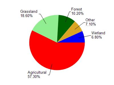
Pigeon Lake is located in the Pigeon River watershed which is 78.87 mi². Land use in the watershed is primarily agricultural (57.30%), grassland (18.60%) and a mix of forest (10.20%) and other uses (13.90%). This watershed has 110.34 stream miles, 769.54 lake acres and 3,149.60 wetland acres.
Nonpoint Source Characteristics
This watershed is ranked High for runoff impacts on streams, Not Ranked for runoff impacts on lakes and High for runoff impacts on groundwater and therefore has an overall rank of High. This value can be used in ranking the watershed or individual waterbodies for grant funding under state and county programs.However, all waters are affected by diffuse pollutant sources regardless of initial water quality. Applications for specific runoff projects under state or county grant programs may be pursued. For more information, go to surface water program grants.