Manitowoc
No
No
Yes
Fish and Aquatic Life
Overview
Water quality in Silver Lake is generally poor to very poor, falling into the eutrophic to hypereutrophic category (see Nonpoint source control Plan for the Seven mile Silver Creek Priority Watershed Plan (PWP) report for a complete description of physical features).
Summer surface water column total phosphorus levels average 184 ug/l. Mats of filamentous algae cover a large portion of the lake bottom and summer algal blooms result in foul odors and an unsightly build-up of algae biomass on the shoreline. In addition, trophic conditions in the lake limit rooting depth for emergent vegetation used by the resident fish populations. As a result, these impairments impact the recreational/ aesthetic value of the lake and stress sport fish populations.
Date 2005
Author Aquatic Biologist
Overview
Silver Lake has an area of 67 acres, a maximum depth of 40 feet, and a mean depth of 16 feet. Total shoreline length is 2.20 miles, of which a portion, including a boat ramp, is open to the public. The existing watershed for the lake covers 12,000 acres and includes English Lake, which intermittently drains into the lake via Silver Creek.
Historically Silver Creek did not drain into Silver Lake as it currently does. A road construction project in the 1930s diverted Silver Creek into Silver Lake and resulted in the lake receiving drainage and nutrients from a much larger watershed. About 10 acres of wetlands adjoin the lake. Silver Creek enters at the northeast end of the lake and exits a short distance away. A feasibility study completed in 1985 indicated that approximately 95 percent of the annual phosphorus loading to the lake was delivered by Silver Creek. Holy Family Convent and minimal residential development surround the lake. Northern pike and panfish are common, and largemouth bass are present.
A project proposes to rectify the artificially modified watershed for Silver Lake and restore it to more natural conditions by rerouting Silver Creek so that it doesn?t drain into the lake. This project has a large group of partners and support and was implemented between 2001 and 2003. By rerouting Silver Creek, the drainage basin for Silver Lake was reduced from 12,000 acres to 500 acres and the nutrient loading to the lake by as much as 95%. After the diversion project was completed a rough fish control project was implemented using Rotenone.
Once the rough fish populations were controlled a lake alum treatment was implemented to remove excess nutrients from the water column and form a cap to minimize future recirculation of lake bed sediments and nutrients. Fish stocking was the last step in the recovery process. Post project aquatic plant management activities focus on establishing and maintaining a healthy aquatic plant community that provides high quality habitat.
In 1965 the lake was treated with toxaphene to eradicate rough fish. The lake was restocked, but carp returned and are present at nuisance levels. Using the phosphorus classification scheme, Silver Lake falls into Class 1B category. A lake management district was created in 1979 and a lake feasibility study done in 1980 (WDNR 1985). Silver Lake is severely limited by excessive algae and both winter and summer fish kills. Small panfish and bullheads are the main components of the fishery (Hogler, 1996). Northern pike, sucker and carp seasonally run to Silver Lake to spawn. The northern pike will travel even further than Silver Lake to Silver Creek marshy areas to headwaters to spawn (Hogler 1995). The results of the lake feasibility study indicate the lake is hyper-eutrophic with the phosphorus loading more than 20 times the acceptable level. Reductions in the phosphorus loading allow the trophic status of the lake to improve. The lake has excellent fishery potential, but is limited by the extremely poor water quality and the large, persistent rough fish population. In the lake feasibility study the annual phosphorus loading to Silver Lake was estimated to be approximately 10,000 pounds per year, with 97 percent of the loading attributed to agricultural sources. The lake's watershed contains 78 livestock operations estimated to produce the majority of the remaining phosphorus loading to Silver Lake. This estimate includes barnyard runoff and phosphorous loading from spread manure. Streambank erosion accounts for a negligible portion of the phosphorus loading to Silver Lake.
Date 2000
Author Aquatic Biologist
Historical Description
Source: 1968, Surface Water Resources of Manitowoc County Silver Lake, T19N, R23E, Sections 33, 34 Surface acres - 66.6, S.D.F. = 1.92, Maximum depth = 40 feet.
A seepage lake in glacial outwash. Silver Creek enters the lake at the northeast end and drains the lake from its outlet at the east end. Muck is the primary littoral material with some gravel present. Largemouth bass, panfish and northern pike comprise the fishery. Major use problems include winterkill, summerkill, and pollution. A Convent is the only establishment on the shoreline. About 70% of the shoreline is wild and 10 acres of this are wetland, half of which is wooded. Public access is available at a launching site on Highway 151. The use of outboard motors is prohibited. The entire lake is a wildlife refuge and substantial numbers of waterfowl visit the area in the spring and fall. No hunting is permitted.
Date 1968
Author Surface Water Inventory Of Wisconsin
Recommendations
Monitor Water Quality or Sediment
Lakes assessment Silver Lake 67400
Monitor Paleocore
One sediment core was taken from Silver Lake in 1995. Diatom analysis was done.
Habitat Restoration - Lake
The Manitowoc County Lakes Association proposes to complete Phase 2 of the Silver Lake restoration project. This project will significantly reduce the internal nutrient loading contribution to Silver Lake and reclaim a balanced fishery and lake habitat.
Lake Management Plan Development
The Silver Lake Protection and Rehabilitation District proposes to complete the diversion of Silver Creek from Silver Lake which will immediately and significantly lower the amount of sediment and organic loading from the creek into the lake and inhibit migration of undesirable fish species into the lake. The project will consist of bank riprap, outlet control structure, peat berm, maintenance, site ground work, design and consultant services and other miscellaneous structures and activities.
Lakes Protection Grant
The Silver Lake Protection and Rehabilitation District proposes to conduct a lake restoration project on Silver Lake, Manitowoc County. Restoration activities covered under this agreement include the diversion of Silver Creek, stabilization of the existing channel through riprapping, analyzing and determining the feasibility of different diversion alternatives, and producing a preliminary and final design of the chosen alternatives.
TMDL Implementation
Silver Lake, located in Manitowoc Rapids Township, Manitowoc County, Wisconsin, in the Manitowoc River Basin, was listed as impaired due to excess phosphorus. The Lake is nutrient (phosphorus (P)) impaired as a result of agriculture, internal loading and local land use, is listed on the 1998 303(d) list as a high priority water and external load sources are nonpoint source (NPS) dominated. The designated use for Silver Lake is a full recreation, warm water sport fishery. Pollutant export data and information on the soils, topography, and other background information on the Silver Lake watershed is included in the Nonpoint Source Pollution Control Plan for the Sevenmile-Silver Creek Priority Watershed, dated February 1987.
TMDL Actions in Wisconsin
Silver Lake (WBIC: 67400), located in Manitowoc Rapids Township, Manitowoc County, Wisconsin, in the Manitowoc River Basin, was listed as impaired due to excess phosphorus. The Lake is nutrient (phosphorus (P)) impaired as a result of agriculture, internal loading and local land use, is listed on the 1998 303(d) list as a high priority water and external load sources are nonpoint source (NPS) dominated. The designated use for Silver Lake is a full recreation, warm water sport fishery.
Management Plans
Silver Lake has an area of 67 acres, a maximum depth of 40 feet, and a mean depth of 16 feet. Total shoreline length is 2.20 miles, of which a portion, including a boat ramp, open to the public. The drainage basin covers 1 square mile and includes English Lake, which intermittently drains into the lake via Silver Creek. About 10 acres of wetlands adjoin the lake. Silver Creek enters at the northeast end of the lake and exits a short distance away. A feasibility study completed in 1985, indicated that approximately 95 percent of the annual phosphorus loading to the lake was delivered by Silver Creek. Holy Family Convent and minimal residential development surround the lake. Northern pike and panfish are common, and largemouth bass are present. In 1965 the lake was treated with toxaphene to eradicate rough fish. The lake was restocked, but carp returned and are present at nuisance levels. Silver Lake Manitowoc County T19N, R23E, Sec. 33, 34
Using the phosphorus classification scheme, Silver Lake falls into Class 1B category. A lake management district was created in 1979 and a lake feasibility study done in 1980 (WDNR 1985). Silver Lake is severely limited by excessive algae and both winter and summer fish kills. Small panfish, and bullheads are the main components of the fishery (Hogler, 1996). Northern pike, sucker and carp seasonally run to Silver Lake to spawn. The northern pike will travel even further than Silver Lake to Silver Creek marshy areas to headwaters to spawn (Hogler 1995). The results of the lake feasibility study indicate the lake is hyper-eutrophic with the phosphorus loading more than 20 times the acceptable level. Reductions in the phosphorus loading would allow the trophic status of the lake to improve. The lake has excellent fishery potential, but is limited by the extremely poor water quality and the large, persistent rough fish population. In the lake feasibility study the annual phosphorus loading to Silver Lake was estimated to be approximately 10,000 pounds per year, with 97 percent of the loading attributed to agricultural sources.
The lake's watershed contains 78 livestock operations estimated to produce the majority of the remaining phosphorus loading to Silver Lake. This estimate includes barnyard runoff and phosphorous loading from spread manure. Streambank erosion accounts for a negligible portion of the phosphorus loading to Silver Lake. The Holy Family Convent waste water treatment plant serves the Holy Family Convent, Silver Lake College, St. Joseph Church and School, and a convent retirement home. The treatment plant was originally constructed in 1950. In 1969, chlorination equipment was added. In 1972, the facilities were further upgraded with the addition of phosphorus removal equipment and buildings over the Imhoff tank and trickling filter (WDNR 1996). In 1996, a dechlorination system was added to the wastewater treatment plant (Free, 1996).
Date 1997
Author Aquatic Biologist
Monitoring
Monitoring the condition of a river, stream, or lake includes gathering physical, chemical, biological, and habitat data. Comprehensive studies often gather all these parameters in great detail, while lighter assessment events will involve sampling physical, chemical and biological data such as macroinvertebrates. Aquatic macroinvertebrates and fish communities integrate watershed or catchment condition, providing great insight into overall ecosystem health. Chemical and habitat parameters tell researchers more about human induced problems including contaminated runoff, point source dischargers, or habitat issues that foster or limit the potential of aquatic communities to thrive in a given area. Wisconsin's Water Monitoring Strategy was recenty updated.
Grants and Management Projects
Monitoring Projects
| WBIC | Official Waterbody Name | Station ID | Station Name | Earliest Fieldwork Date | Latest Fieldwork Date | View Station | View Data |
|---|
| 67400 | Silver Lake | 363312 | Silver Lake - East Basin Deep Spot | 11/1/1995 | 4/6/2025 | Map | Data |
| 67400 | Silver Lake | 10003522 | Silver Lake | 4/13/1994 | 7/16/2024 | Map | Data |
| 67400 | Silver Lake | 363346 | Silver Lake - Deep Hole - West Basin | | | Map | Data |
| 67400 | Silver Lake | 10019640 | Silver Lake -- Access at Just Off Hwy 151 Manitowoc | 6/11/2008 | 6/8/2025 | Map | Data |
| 67400 | Silver Lake | 363209 | Silver Lake - Holy Family Convent Stp | 11/17/1975 | 8/11/1983 | Map | Data |
| 67400 | Silver Lake | 10038251 | Silver Lake (Manitowoc Co) nearshore site | 8/29/2012 | 8/29/2012 | Map | Data |
| 67400 | Silver Lake | 363080 | Silver Lake - Deep Hole-West Basin | 5/3/1979 | 8/27/2024 | Map | Data |
|
Projects
The Silver Lake Protection and Rehabilitation District has received two lake planning grants. Some of this funding was used to determine total phosphorus and water budgets for the lake. Funds were also used for planning a partial diversion of Silver Creek, which may eliminate some of the nutrient inputs to the lake. Once the diversion is completed carp and bullhead populations need to be controlled, and then an aluminate treatment, and possibly aeration, would be used to remove phosphorus from the water column. NR 120 will fund 70 percent of the cost of the aluminate treatment, but none of the diversion costs. The plan was developed under the lake planning grant and is in the implementation stage (Rasman 1995). A partial diversion was completed in fall 1995, utilizing Lake Protection Grant Program funds. Eventually it is hoped to completely divert Silver Creek around the lake, at which point fisheries management will address future management needs. A hydraulic evaluation of the partial diversion of Silver Creek will be conducted between September, 1996, and May, 1997. Modeling and monitoring will be conducted to determine the present fraction of Silver Creek inflows that move directly to the outlet from Silver Lake without mixing the lake water and evaluate alternative schemes to maximize inflow bypassing. A project report will be completed in July, 1997. This study will be a cooperative effort among several agencies: UW-Madison, WDNR, Manitowoc County Soil & Water Conservation Department, and the Silver Lake Protection and Rehabilitation District.
A fish kill was reported on April 19, 1996, thousands of dead fish were observed floating in Silver Lake. Low dissolved oxygen levels was the suspected cause of the kill. Fisheries staff surveyed the lake by examining the entire shoreline, and multiple transects across open water to determine the species affected, and the mortality numbers for each species. A total of 5,791 dead fish were counted. This included 5,598 carp, 186 panfish (mostly black crappie), 1 black bullhead, 1 walleye, 2 largemouth bass, and 3 white sucker. The Silver Lake Protection and Rehabilitation District members and many other volunteers removed the dead fish from the lake, and reported that 18,000 pounds were taken the landfill. To determine the fish species remaining in the lake Fisheries Management set two fyke nets for three nights each. A total of 298 fish were caught; 92 golden shiner, 77 black crappie, 64 black bullhead, 27 yellow perch, 16 northern pike, 14 white sucker, and 8 carp. Additional surveys may be conducted to further assess the remaining fish populations (Hogler 1996).
Date 1997
Author Aquatic Biologist
Watershed Characteristics
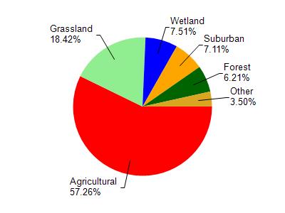
Silver Lake is located in the Sevenmile and Silver Creeks watershed which is 112.90 mi². Land use in the watershed is primarily agricultural (57.20%), grassland (18.40%) and a mix of wetland (7.50%) and other uses (16.80%). This watershed has 184.08 stream miles, 10,577.89 lake acres and 4,732.70 wetland acres.
Nonpoint Source Characteristics
This watershed is ranked High for runoff impacts on streams, Not Ranked for runoff impacts on lakes and High for runoff impacts on groundwater and therefore has an overall rank of High. This value can be used in ranking the watershed or individual waterbodies for grant funding under state and county programs.This water is ranked High Lake for individual Lakes based on runoff problems and the likelihood of success from project implementation.