Calumet
No
No
Yes
Fish and Aquatic Life
Overview
The Hayton Millpond site near New Holstein in Calumet County was discovered in 1990, after tests revealed high PCB levels in fish from the South Branch of the Manitowoc River and investigation showed the contamination centralized in the backwaters of the Hayton Millpond and nearby farm fields.
The cause of those contaminants is unknown, but Tecumseh, which owns land next to the contaminated fields, has agreed to work with the Department of Natural Resources to clean up the PCBs.
Cleanup work at the Hayton Millpond site enters a critical phase this week as removal proceeds down Jordan Creek. PCB levels along Jordan Creek are 200 to 1,000 times the target cleanup level, according to Jim Baumann, DNR’s project manager.
This first phase of the cleanup is expected to cost $60 million, which two companies will fund.
from: AmeriScan: September 20, 2004
http://www.ens-newswire.com/ens/sep2004/2004-09-20-09.asp#anchor6
Date 2004
Author Aquatic Biologist
Overview
Jordan Creek originates southeast of New Holstein and flows northerly for 1.2 miles, partly through the
east side of New Holstein, before draining into Pine Creek, which flows into the South Branch near
Hayton. The New Holstein WWTP outfall is on Jordan Creek. Tecumseh Products, Inc. is also located on
this channel and due to previous water quality standard violations it now discharges to the WWTP. The
current stream classification for Jordan Creek is Limited Aquatic Life (LAL). The district water quality
biologist suggests the classification for Jordan Creek should be a warm water forage fishery (WWFF) and
that it be changed in the next revision of NR 104. This proposed change may require more strict effluent
limits for the City of New Holstein WPDES Permit.
From: Willman, Guy and Mike Toneys. 2001. The State of the Lakeshore Basin. Wisconsin Department of Natural Resources, Madison, WI.
Date 2001
Author Michael Toneys
Historical Description
Bush, D.M., R. Cornelius, D. Engle, and C.L. Brynildson. 1980. Lake and Stream Classification Project. Surface Water Resources of Green County, 2nd Edition. Wisconsin Department of Natural Resources, Madison, Wisconsin.This moderate sized, warm water stream flows southward entering Skinner Creek near Browntown. It flows through cropland and pasture and severe bank erosion is evident throughout, especially in the upper third where most
of the surrounding land is pastured. The entire lower third of the stream has been ditched for drainage, yet 110 acres of wetland still remain near Skinner Creek. The turbid water lacks instream cover and macrophytic vegetation. Silt and muck are the predominant bottom types.
Although a few catfish and smallmouth bass may be found in the lower end of the stream, the fishery is dominated by forage species. Game values are fair with a significant population of muskrats and occasional stops by migratory waterfowl. Public access and frontage consists of seven public road crossings.
Fish Species: Central stoneroller, carp, common shiner, bigmouth shiner, southern redbelly dace, bluntnose minnow, fathead minnow, creek chub, white sucker, channel catfish, brook stickleback, smallmouth bass, .green sunfish x pumpkinseed hybrid, fantSurface Acres = 18.0. Length = 10.0 ~1iles. Gradient = 25 ft./mi.. Base Oischarge = 13.0 cu. ft./sec.ail darter, Johnny darter
Date 1980
Author Surface Water Inventory Of Wisconsin
Condition
Wisconsin has over 84,000 miles of streams, 15,000 lakes and milllions of acres of wetlands. Assessing the condition of this vast amount of water is challenging. The state's water monitoring program uses a media-based, cross-program approach to analyze water condition. An updated monitoring strategy (2015-2020) is now available. Compliance with Clean Water Act fishable, swimmable standards are located in the Executive Summary of Water Condition in 2018. See also the 'monitoring and projects' tab.
Reports
Recommendations
TMDL Monitoring
The Hardies Creek TMDL is a product of a partnership between the Wisconsin Department of Natural Resources (WDNR) and the Galesville-Ettrick-Trempealeau High School (GET) Science Department. In 2004, the WDNR provided funding, through a local water quality assistance grant to GET, to support supplemental data collection for the development of the TMDL. In coordination with WDNR field staff and under the direction of Mr. Jon Johnson (GET Science Teacher), students monitored habitat, macroinvertebrates, and water chemistry and assisted with fish electro-shocking in Hardies creek. Some of the information collected by students with WDNR supervision was used in the development of this TMDL.
TMDL Implementation
EAP project
Management Goals
Wisconsin's Water Quality Standards provide qualitative and quantitative goals for waters that are protective of Fishable, Swimmable conditions [Learn more]. Waters that do not meet water quality standards are considered impaired and restoration actions are planned and carried out until the water is once again fishable and swimmable
Management goals can include creation or implementation of a Total Maximum Daily Load analysis, a Nine Key Element Plan, or other restoration work, education and outreach and more. If specific recommendations exist for this water, they will be displayed below online.
Monitoring
Monitoring the condition of a river, stream, or lake includes gathering physical, chemical, biological, and habitat data. Comprehensive studies often gather all these parameters in great detail, while lighter assessment events will involve sampling physical, chemical and biological data such as macroinvertebrates. Aquatic macroinvertebrates and fish communities integrate watershed or catchment condition, providing great insight into overall ecosystem health. Chemical and habitat parameters tell researchers more about human induced problems including contaminated runoff, point source dischargers, or habitat issues that foster or limit the potential of aquatic communities to thrive in a given area. Wisconsin's Water Monitoring Strategy was recenty updated.
Grants and Management Projects
Monitoring Projects
| WBIC | Official Waterbody Name | Station ID | Station Name | Earliest Fieldwork Date | Latest Fieldwork Date | View Station | View Data |
|---|
| 80200 | Jordan Creek | 083101 | Jordan Creek - Tecumseh Ditch Woefel Pasture Meadow (Floodplain) | 9/20/2001 | 9/20/2001 | Map | Data |
| 80200 | Jordan Creek | 083115 | Jordan Creek - Near New Holstein WI | 6/18/1996 | 6/18/1996 | Map | Data |
| 80200 | Jordan Creek | 10038044 | HAYTON MILLPOND JORDAN CREEK - 600 FEET UPSTREAM OF TECUMSEH RD | 9/1/1993 | 9/1/1993 | Map | Data |
| 80200 | Jordan Creek | 363261 | Jordan Creek at Tecumseh Rd | 4/28/1992 | 8/4/1994 | Map | Data |
| 80200 | Jordan Creek | 10015684 | Jordan Creek - Tecumseh Road Crossing (Upstream Of Private Crossing) | 8/15/2006 | 1/1/2015 | Map | Data |
| 80200 | Jordan Creek | 10012548 | South Tributary to Jordan Creek at Outfall | 11/12/1992 | 8/21/2006 | Map | Data |
| 80200 | Jordan Creek | 10012550 | Jordan Creek Dwnstr. Wwtp | 6/23/2003 | 8/21/2006 | Map | Data |
| 80200 | Jordan Creek | 10041492 | Jordan Creek at Charlesburg Bridge | 9/20/2001 | 9/20/2001 | Map | Data |
| 80200 | Jordan Creek | 10038093 | PINE CREEK JORDAN CREEK - 50 FEET DOWNSTREAM OF DUMP DITCH | 11/12/1992 | 11/12/1992 | Map | Data |
| 80200 | Jordan Creek | 10021275 | Jordan Creek Along Tecumseh Rd. 800 Feet Above Confl. With Pine Cr. | 6/11/1992 | 10/6/2017 | Map | Data |
| 80200 | Jordan Creek | 10012554 | Jordan Creek At Confluence With Pine Creek | 9/7/1989 | 8/23/2006 | Map | Data |
| 80200 | Jordan Creek | 10038097 | PINE CREEK JORDAN CREEK - MOUTH OF DUMP DITCH | 11/12/1992 | 11/12/1992 | Map | Data |
| 80200 | Jordan Creek | 10012553 | Jordan Creek Dwnstr. Of N. Trib. | 6/24/2003 | 8/22/2006 | Map | Data |
| 80200 | Jordan Creek | 10038183 | HAYTON MILLPOND JORDAN CREEK - 300 FT DS DUMP DITCH | 9/1/1993 | 9/1/1993 | Map | Data |
| 80200 | Jordan Creek | 083050 | Jordan Creek - Above New Holstien | | | Map | Data |
| 80200 | Jordan Creek | 10038094 | PINE CREEK JORDAN CREEK - 30 FEET BELOW TECUMSEH DITCH | 11/12/1992 | 11/12/1992 | Map | Data |
| 80200 | Jordan Creek | 083102 | Jordan Creek - Tecumseh Ditch At Charlesburg Rd. Bridge | | | Map | Data |
|
Watershed Characteristics
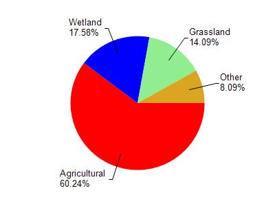
Jordan Creek is located in the South Branch Manitowoc River watershed which is 189.10 mi². Land use in the watershed is primarily agricultural (60.30%), wetland (17.60%) and a mix of grassland (14.10%) and other uses (8.10%). This watershed has 228.03 stream miles, 86.31 lake acres and 21,287.68 wetland acres.
Nonpoint Source Characteristics
This watershed is ranked High for runoff impacts on streams, High for runoff impacts on lakes and High for runoff impacts on groundwater and therefore has an overall rank of High. This value can be used in ranking the watershed or individual waterbodies for grant funding under state and county programs.However, all waters are affected by diffuse pollutant sources regardless of initial water quality. Applications for specific runoff projects under state or county grant programs may be pursued. For more information, go to surface water program grants.