Iowa
Yes
No
No
Fish and Aquatic Life
Overview
Lowery Creek is a tributary to the Wisconsin River west of Tower Hill State Park. The creek supports a warm water sport fishery for its lower 1.5 miles and is considered a Class II trout stream for much of the rest of its length. The creek has problems with streambank pasturing and hydrologic modification.
Date 2002
Author Cynthia Koperski
Historical Description
Lowery Creek (VanBlarcum, Jones) - Mouth location T8N R4E Section 30 -5, Surface area = 5.0 acres, length = 6.5 miles, Gradient = 27.7 feet per mile, Total alkalinity = 233.0 mg/l, Volume of flow = 1.5 cfs.
Lowery Creek is a small spring fed trout stream which flows northerly and empties directly into the Wisconsin River. Although it has a lower- than-average gradient, severe flooding and resultant bank erosion are serious problems. Every year the lands in the watershed are farmed less which results in more stable water levels. Presently, about 60 percent is still farmed. Its lower section is impounded to form Upper and Lower Taliesin Lakes which are private, being located in the Frank Lloyd Wright estate of Taliesin. They are discussed in the lake section. The stream sport fishery consists of qrown trout which have been shown to reproduce naturally in its upper sections. They are stocked annually to supplement the fishery. A seining survey showed that forage fishes which are present include white suckers; brassy, stoneroller and bluntnose minnows; creek chubs and johnny darters. Game assets consist of muskrats and ducks in the lower sections. There are no public lands on this stream. Presently, there is access from seven road crossings.
From: Piening, Ronald and Threinen, C.W., 1968. Lake and Stream Classification Project. Surface Water Resources of Iowa County, Wisconsin Department of Natural Resources, Madison, WI.
Date 1968
Author Surface Water Inventory Of Wisconsin
Condition
Wisconsin has over 84,000 miles of streams, 15,000 lakes and milllions of acres of wetlands. Assessing the condition of this vast amount of water is challenging. The state's water monitoring program uses a media-based, cross-program approach to analyze water condition. An updated monitoring strategy (2015-2020) is now available. Compliance with Clean Water Act fishable, swimmable standards are located in the Executive Summary of Water Condition in 2018. See also the 'monitoring and projects' tab.
Reports
Recommendations
Partnership Project
DALC will conduct a project to initiate a vision for the watershed to promote sound ag practices, land protection & management & stream restoration to benefit stream protection & water quality. Project goals:1) Establish vision, goals & strategies for a watershed vision to improve water quality & other resources in the next 3-5 years. 2) Develop strategic plan based on an impact mapping process. 3) Facilitate partnership meetings to establish goals related to water quality, aesthetic & cultural resources. 4) Outline activities for the next 3-5 years that lead partners toward goals, to include prioritizing, scheduling & budgeting specific activities. 5) Invite watershed residents, landowners, & stakeholders to an ag field trip demonstrating sound ag practices to protect water quality. 6) Hold partnership event that provides watershed info & a vision & strategic plan via the Impact Mapping process. 7) Conduct meetings to discuss land protection. Deliverables are as follows: 1) Include a vision, goals, objectives in a strategic plan to maximize impacts towards goals developed for the watershed to promotes water quality, & protects biological richness. 2) Outline activities for next 3-5 years to include prioritizing, scheduling & budgeting for specific activities. 3)Press release & invitations will be sent to stakeholders, & at least 15 people will attend an ag field trip to develop interest in implementing BMP to improve water quality. 4) Press release & invitations will be sent to stakeholders, & at least 20 people will attend a meeting to learn about resources, issues & water quality in the watershed. 5) Focus group & one-on-one outreach to provide information about land protection. 6) Complete one easement project in the watershed by end of grant period. 6) Results of planning process will be shared with landowners, town boards, & other stakeholders through a press release, newsletter articles, a town board meeting, & watershed wide stakeholder meeting.
Management Goals
Wisconsin's Water Quality Standards provide qualitative and quantitative goals for waters that are protective of Fishable, Swimmable conditions [Learn more]. Waters that do not meet water quality standards are considered impaired and restoration actions are planned and carried out until the water is once again fishable and swimmable
Management goals can include creation or implementation of a Total Maximum Daily Load analysis, a Nine Key Element Plan, or other restoration work, education and outreach and more. If specific recommendations exist for this water, they will be displayed below online.
Monitoring
Monitoring the condition of a river, stream, or lake includes gathering physical, chemical, biological, and habitat data. Comprehensive studies often gather all these parameters in great detail, while lighter assessment events will involve sampling physical, chemical and biological data such as macroinvertebrates. Aquatic macroinvertebrates and fish communities integrate watershed or catchment condition, providing great insight into overall ecosystem health. Chemical and habitat parameters tell researchers more about human induced problems including contaminated runoff, point source dischargers, or habitat issues that foster or limit the potential of aquatic communities to thrive in a given area. Wisconsin's Water Monitoring Strategy was recenty updated.
Grants and Management Projects
Monitoring Projects
| WBIC | Official Waterbody Name | Station ID | Station Name | Earliest Fieldwork Date | Latest Fieldwork Date | View Station | View Data |
|---|
| 1241400 | Lowery Creek | 10029600 | Lowery Cr. Station 3 | 1/1/2015 | 1/1/2015 | Map | Data |
| 1241400 | Lowery Creek | 253196 | Lowery Creek at Farm Driveway Nr Spring Green | 6/19/2001 | 5/13/2025 | Map | Data |
| 1241400 | Lowery Creek | 10040801 | Lowery Cr ~2700 DS of Far Look Rd | 1/1/2015 | 1/1/2015 | Map | Data |
| 1241400 | Lowery Creek | 10053946 | Lowery Creek at Far Look Road | 11/3/2020 | 11/3/2020 | Map | Data |
|
Watershed Characteristics
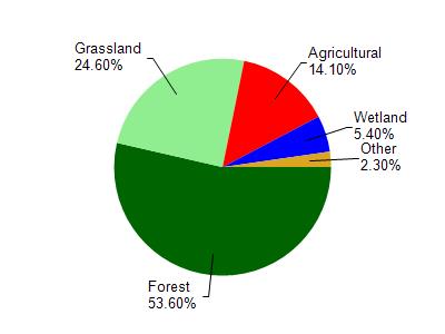
Lowery Creek is located in the Otter and Morrey Creeks watershed which is 198.69 mi². Land use in the watershed is primarily forest (53.60%), grassland (24.60%) and a mix of agricultural (14.10%) and other uses (7.70%). This watershed has 437.57 stream miles, 351.55 lake acres and 5,785.74 wetland acres.
Nonpoint Source Characteristics
This watershed is ranked Not Ranked for runoff impacts on streams, Low for runoff impacts on lakes and High for runoff impacts on groundwater and therefore has an overall rank of High. This value can be used in ranking the watershed or individual waterbodies for grant funding under state and county programs.However, all waters are affected by diffuse pollutant sources regardless of initial water quality. Applications for specific runoff projects under state or county grant programs may be pursued. For more information, go to surface water program grants.