Adams
No
No
Yes
Fish and Aquatic Life
Overview
Lake Arrowhead is a 295-acre impoundment of Fourteenmile Creek in the town of Rome created by a dam operated by the Adams County Land Conservation District.
Date 2011
Author Aquatic Biologist
Impaired Waters
Lake Arrowhead (WBIC 1377700) was placed on the impaired waters list for excess algal growth in 2014. The 2018 assessments showed continued excess algal growth; new chlorophyll-a sample data exceeded the 2018 WisCALM listing thresholds for the Recreation use. Total phosphorus data were clearly below the Recreation use and Fish and Aquatic Life use listing thresholds. Based on the most updated information, no change in the existing impaired waters listing was needed.
Date 2017
Author Ashley Beranek
Impaired Waters
Lake Arrowhead (1377700) was placed on the impaired waters list for excess algal growth in 2014. The 2016 assessments showed continued excess algal growth; chlorophyll sample data exceed 2016 WisCALM listing thresholds for the Recreation use, however, total phosphorus data do not exceed REC thresholds. Total phosphorus and chlorophyll data do not exceed Fish and Aquatic Life thresholds. Based on the most updated information, no change in existing impaired waters listing is needed.
Date 2015
Author Aaron Larson
Condition
Wisconsin has over 84,000 miles of streams, 15,000 lakes and milllions of acres of wetlands. Assessing the condition of this vast amount of water is challenging. The state's water monitoring program uses a media-based, cross-program approach to analyze water condition. An updated monitoring strategy (2015-2020) is now available. Compliance with Clean Water Act fishable, swimmable standards are located in the Executive Summary of Water Condition in 2018. See also the 'monitoring and projects' tab.
Reports
Recommendations
Nutrient Strategy Priority
Adams County proposes to develop nutrient management plans for 4,470 acres of crop land within the Tri-Lakes Watershed. Major project elements to include: a) outreach to landowners, b) development of nutrient management plans, c) weekly water sampling, d) water quality analysis, and e) cost share payments.
Shoreland Ordinance
Adams County proposes to amend or create a shoreland zoning ordinance that complies with the requirements of NR 115, Wisconsin Administrative Code (as revised effective February 1, 2010) and retain existing regulations that exceed the water resource protections of NR 115 or are specific or unique to local needs.
Stormwater Planning, Implementation
Stormwater, shoreline restoration, riprap
Lake Classification
Adams County proposes to wrap up its county-wide lake classification effort. Major project elements to include: 1) completion of water sampling, 2) development of lakes classification report and individual lake summaries, 3) development of a powerpoint presentation, 4) four public meetings, 5) expansion of shoreline restoration packet.
Lake Classification
Adams County continue its lake classification efforts through collecting and assessing chemical and biological data on all lakes within the county that afford public access. Major project componants to include: 1) collection and assessment of chemical and biological data, 2) development of a "library" of information for public use, 3) development of management recommendations, 4) I&E for riparians and lake users.
Lake Classification
Adams County proposes to initiate a Lakes Classification effort to assist in comprehensive plan development for communities surrounding its lakes with public access. Phase 1 elements, to be funded with this grant, include: 1) delination of surface watersheds and flow patterns, 2) delineation of ground watersheds, 3) identification and mapping of land uses, 4) inventory and mapping of shoreline erosion and development problems, 5) identification and mapping of sensitive/critical areas and natural heritage habitats, 6) verification of wetland delineations, 7) delineations of lake watersheds, 8) development of lake maps
County Land and Water Management Plan
http://www.ncwrpc.org/adams/lwrmp/1_DRAFT%20Adams%20LWRMP_11-10-15%20Wally_CD-ROM.pdf
Management Goals
Wisconsin's Water Quality Standards provide qualitative and quantitative goals for waters that are protective of Fishable, Swimmable conditions [Learn more]. Waters that do not meet water quality standards are considered impaired and restoration actions are planned and carried out until the water is once again fishable and swimmable
Management goals can include creation or implementation of a Total Maximum Daily Load analysis, a Nine Key Element Plan, or other restoration work, education and outreach and more. If specific recommendations exist for this water, they will be displayed below online.
Monitoring
Monitoring the condition of a river, stream, or lake includes gathering physical, chemical, biological, and habitat data. Comprehensive studies often gather all these parameters in great detail, while lighter assessment events will involve sampling physical, chemical and biological data such as macroinvertebrates. Aquatic macroinvertebrates and fish communities integrate watershed or catchment condition, providing great insight into overall ecosystem health. Chemical and habitat parameters tell researchers more about human induced problems including contaminated runoff, point source dischargers, or habitat issues that foster or limit the potential of aquatic communities to thrive in a given area. Wisconsin's Water Monitoring Strategy was recenty updated.
Grants and Management Projects
Monitoring Projects
| WBIC | Official Waterbody Name | Station ID | Station Name | Earliest Fieldwork Date | Latest Fieldwork Date | View Station | View Data |
|---|
| 1377700 | Lake Arrowhead | 10030161 | Arrowhead Lake - Private Landing - South Lake Center | 9/8/2011 | 7/12/2013 | Map | Data |
| 1377700 | Lake Arrowhead | 10031431 | Arrowhead Lake - Drain on dam (#2) | 8/3/2010 | 8/8/2016 | Map | Data |
| 1377700 | Lake Arrowhead | 10021590 | Arrowhead Lake - E | 7/24/2007 | 7/24/2007 | Map | Data |
| 1377700 | Lake Arrowhead | 10021595 | Arrowhead Lake - H | 7/24/2007 | 7/24/2007 | Map | Data |
| 1377700 | Lake Arrowhead | 10000542 | Arrowhead Lake | 6/1/1992 | 12/10/2017 | Map | Data |
| 1377700 | Lake Arrowhead | 10030160 | Arrowhead Lake - Private Landing - Mid-Lake Center | 6/23/2009 | 8/14/2015 | Map | Data |
| 1377700 | Lake Arrowhead | 013036 | Arrowhead Lake - Just Off Mouth Of Main Inlet Creek | 7/18/1991 | 7/6/2011 | Map | Data |
| 1377700 | Lake Arrowhead | 10021588 | Arrowhead Lake - D | 7/24/2007 | 7/24/2007 | Map | Data |
| 1377700 | Lake Arrowhead | 10060260 | Arrowhead Lake Control | 7/9/2024 | 7/28/2025 | Map | Data |
| 1377700 | Lake Arrowhead | 10017915 | Lake Arrowhead -- Access Nr 15th Ave And Council Hill Trl | 5/28/2005 | 8/31/2025 | Map | Data |
| 1377700 | Lake Arrowhead | 10021593 | Arrowhead Lake - G | 7/24/2007 | 7/24/2007 | Map | Data |
| 1377700 | Lake Arrowhead | 10031430 | Arrowhead Lake - Drain on dam (#1) | 8/3/2010 | 1/10/2018 | Map | Data |
| 1377700 | Lake Arrowhead | 10021586 | Arrowhead Lake - B | 7/24/2007 | 7/24/2007 | Map | Data |
| 1377700 | Lake Arrowhead | 013037 | Arrowhead Lake - Deepest Point In Lake Just Above Dam (#5) | 10/29/1985 | 8/11/2025 | Map | Data |
| 1377700 | Lake Arrowhead | 10028945 | Arrowhead Lake (#6) | 10/29/1985 | 8/30/2017 | Map | Data |
| 1377700 | Lake Arrowhead | 10051371 | Lake Arrowhead HAB Complaint | 8/7/2018 | 8/7/2018 | Map | Data |
| 1377700 | Lake Arrowhead | 10021027 | Arrowhead Lake - Deepest Spot | | | Map | Data |
| 1377700 | Lake Arrowhead | 10021585 | Arrowhead Lake - A | 7/24/2007 | 7/24/2007 | Map | Data |
| 1377700 | Lake Arrowhead | 10021596 | Arrowhead Lake - I | 7/24/2007 | 7/24/2007 | Map | Data |
| 1377700 | Lake Arrowhead | 10021598 | Arrowhead Lake - J | 7/24/2007 | 7/24/2007 | Map | Data |
| 1377700 | Lake Arrowhead | 10028946 | Arrowhead Lake (#7) | 10/29/1985 | 8/30/2017 | Map | Data |
| 1377700 | Lake Arrowhead | 10021591 | Arrowhead Lake - F | 7/24/2007 | 7/24/2007 | Map | Data |
| 1377700 | Lake Arrowhead | 10021587 | Arrowhead Lake - C | 7/24/2007 | 7/24/2007 | Map | Data |
| 1377700 | Lake Arrowhead | 013181 | Arrowhead Lake - Beach/Boat Landing Off 15th Ave | 7/7/2004 | 9/8/2004 | Map | Data |
|
Watershed Characteristics
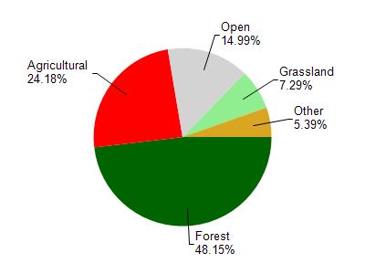
Lake Arrowhead is located in the Fourteenmile Creek watershed which is 184.15 mi². Land use in the watershed is primarily forest (48.20%), agricultural (24.20%) and a mix of open (15%) and other uses (12.70%). This watershed has stream miles, lake acres and 11,432.03 wetland acres.
Nonpoint Source Characteristics
This watershed is ranked Medium for runoff impacts on streams, Medium for runoff impacts on lakes and High for runoff impacts on groundwater and therefore has an overall rank of High. This value can be used in ranking the watershed or individual waterbodies for grant funding under state and county programs.However, all waters are affected by diffuse pollutant sources regardless of initial water quality. Applications for specific runoff projects under state or county grant programs may be pursued. For more information, go to surface water program grants.