Green
Yes
No
No
Fish and Aquatic Life
Overview
The lower one-third of this 3 mile stream is considered Class III trout water. The creek was once a natural brook trout stream with well defined banks, deep pools and abundant riffles, but habitat deterioration has been so severe that it currently only supports a trout fishery through stocking of brown trout. The principal water source is a spring which has been excavated and dammed to form a pond for a private fish hatchery. During the summer, water from the pond is warmed significantly prior to entering the stream (Surface Waters of Green Co.). A fisheries survey conducted in 2002 at the Sugar River Trail Bridge found forage species including sculpin, stickleback, mudminnows, and darters. Heavy siltation was noted in this area whereas upstream areas appear to have better gradient, flow and overall habitat.
Date 2002
Author Aquatic Biologist
Historical Description
Bush, D.M., R. Cornelius, D. Engle, and C.L. Brynildson. 1980. Lake and Stream Classification Project. Surface Water Resources of Green County, 2nd Edition. Wisconsin Department of Natural Resources, Madison, Wisconsin.
This small trout stream flows northeast and enters the Little Sugar River southeast of Monticello. Severe
land misuse and excessive water fertility have led to a serious degradation of the stream's quality. Inordinate deposits of silt make the stream very wide and shallow and the excessive growth of macrophytic vegetation (Ranunculus and Elodea) impedes water flow. The principal water source is a large spring in Section 28 which
has been excavated and dammed forming a pond for a private fish hatchery. During the summer, the pond water
is warmed significantly prior to entering the stream. Hammerly Creek's bottom consists of silt with small patches of sand and gravel. The water is slightly turbid and instream cover is minimal.
The entire stream is considered Class III trout water. The creek was once a natural brook trout stream with well defined banks, deep pools and abundant riffles, but habitat deterioration has been so severe that it currently supports a trout fishery only throuqh the annual stocking of brown trout. Wildlife values consist of muskrats and there are thirty acres of sedge meadow and shrub swamp adjacent to the creek. Public access is ~gjlable from the Sugar River Trail and one public road crossing.
Fish Species: Brown trout, central mudminnow, brook stickleback, mottled sculpin
Surface Acres = 1.1. Length = 1.5 Miles, Gradient = 20 ft./mi.. Base Discharge = 4.9 cu. ft./sec.
Date 1980
Author Surface Water Inventory Of Wisconsin
Historical Description
From: Poff, Ronald J., and C.W. Threinen, Lake and Stream Classification Project. Surface Water Resources of Green County, Wisconsin Conservation Department, Madison I, 1961.
Flows generally northeast to the Little Sugar River. Managed for brook trout and brown trout. The principal water supply is a large spring (800 gallons per minute) located just south of highway 39 in section 27. The stream once had well defined banks and pools up to 3 feet in dept with a good pool to riffle ratio. In recent years the siltation problem has increased until now the stream bed holds up to 16 inches of sediment in most places and conditions have changed to such an extent that filamentous algae are crowding in on the rooted aquatics. With proper watershed management and stream channel improvement it may be possible to reproduce some semblance of the stream as it once was. Since the fishable portion of the stream is so small it may be impractical to attempt reclamation.
Surface Acres= 1.1, Miles= 1.5, Gradient= 26.6' per mile
Date 1961
Author Surface Water Inventory Of Wisconsin
Condition
Wisconsin has over 84,000 miles of streams, 15,000 lakes and milllions of acres of wetlands. Assessing the condition of this vast amount of water is challenging. The state's water monitoring program uses a media-based, cross-program approach to analyze water condition. An updated monitoring strategy (2015-2020) is now available. Compliance with Clean Water Act fishable, swimmable standards are located in the Executive Summary of Water Condition in 2018. See also the 'monitoring and projects' tab.
Reports
Recommendations
Monitor Water Quality or Sediment
Category 3 water with a single 'Poor' fIBI. Further monitoring recommended. AU: 18526l; Station ID: 10033952
Management Goals
Wisconsin's Water Quality Standards provide qualitative and quantitative goals for waters that are protective of Fishable, Swimmable conditions [Learn more]. Waters that do not meet water quality standards are considered impaired and restoration actions are planned and carried out until the water is once again fishable and swimmable
Management goals can include creation or implementation of a Total Maximum Daily Load analysis, a Nine Key Element Plan, or other restoration work, education and outreach and more. If specific recommendations exist for this water, they will be displayed below online.
Monitoring
Monitoring the condition of a river, stream, or lake includes gathering physical, chemical, biological, and habitat data. Comprehensive studies often gather all these parameters in great detail, while lighter assessment events will involve sampling physical, chemical and biological data such as macroinvertebrates. Aquatic macroinvertebrates and fish communities integrate watershed or catchment condition, providing great insight into overall ecosystem health. Chemical and habitat parameters tell researchers more about human induced problems including contaminated runoff, point source dischargers, or habitat issues that foster or limit the potential of aquatic communities to thrive in a given area. Wisconsin's Water Monitoring Strategy was recenty updated.
Grants and Management Projects
Monitoring Projects
| WBIC | Official Waterbody Name | Station ID | Station Name | Earliest Fieldwork Date | Latest Fieldwork Date | View Station | View Data |
|---|
| 880300 | Hammerly Creek | 10009515 | Hammersly Creek Upstream Of Sugar River Recreational Trail Bridge | | | Map | Data |
| 5579134 | Unnamed | 10051046 | SW Bank WBIC 5579134 | 5/14/2018 | 5/14/2018 | Map | Data |
| 880300 | Hammerly Creek | 10033952 | Hammerly Creek at CTH F | 10/12/2011 | 1/31/2018 | Map | Data |
|
Watershed Characteristics
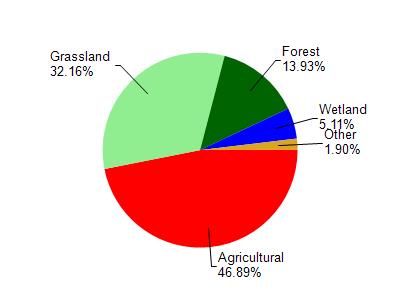
Hammerly Creek is located in the Little Sugar River watershed which is 133.02 mi². Land use in the watershed is primarily agricultural (46.80%), grassland (32.10%) and a mix of forest (13.90%) and other uses (7.00%). This watershed has 351.74 stream miles, 50.40 lake acres and 3,252.10 wetland acres.
Nonpoint Source Characteristics
This watershed is ranked Not Ranked for runoff impacts on streams, Not Ranked for runoff impacts on lakes and High for runoff impacts on groundwater and therefore has an overall rank of High. This value can be used in ranking the watershed or individual waterbodies for grant funding under state and county programs.However, all waters are affected by diffuse pollutant sources regardless of initial water quality. Applications for specific runoff projects under state or county grant programs may be pursued. For more information, go to surface water program grants.