Dane
Yes
No
No
Fish and Aquatic Life
Overview
Henry Creek originates in Section 11 of Montrose Township (T5N, R8E) and flows west before joining the Sugar River (Figure 1). This small first order stream is only 1 mile long. It drains agricultural areas at its headwaters, but is bordered by emergent wet meadow for the lower two thirds of its length. The creek is spring-fed with a relatively steep gradient (WDNR, 1985). Henry Creek is currently classified as a Default Full Fish and Aquatic Life stream. It was placed on the state’s 303(d) list of impaired waters due to habitat impairments caused by sedimentation (WDNR, 1995). Since that time, land use improvements have resulted in good water quality and habitat. Lands that were in agriculture have now returned to wetland meadow and provide a good buffer for the stream. Farm properties near the headwaters have also employed conservation practices to reduce erosion. Amrhein
Date 2006
Author Aquatic Biologist
Overview
Henry Creek is a very small spring fed tributary to the Sugar River near the community of Basco. The stream runs through a small wetland that is part of the larger Sugar River wetland complex. These wetlands serve an important function as a buffer for Henry Creek and the Sugar River, as well as for wildlife, fisheries, and scenic values. Although the stream has been listed on the EPA’s list of impaired waters due to problems caused by nonpoint source pollution, an EQIP project near the headwaters was completed in 1999 (Sutter, pers comm) and may have mitigated some of these impacts. The creek likely has good water quality and fair in-stream habitat (Marshall, pers. comm). Although the stream still contains some silted areas, there are many hard bottom areas of gravel and many undercut banks for fish habitat. Monitoring in 2002 indicated a healthy population of mottled sculpin, along with stickleback and several brown trout. The water temperature is being monitored to determine if the stream can support brook trout. If so, brook trout may be introduced to the stream in 2003.
Date 2002
Author Aquatic Biologist
Historical Description
Henry Creek -T5N, R8E, Sec. 14, Surface acres = 0.1, Length = 1 mile, Stream order = I, Gradient = 27.8 ft/mile,
Base discharge = 1.3 cfs.
This very short, sprlng-fed tributary to the Sugar River is adjoined by approximately 40 acres of fresh meadow at its mouth. The gradIent is steep for this part of the county and water qualIty is good. Henry Creek is not managed for trout because of its small size. A private trout rearing pond has another outlet to the creek and some trout reportedly escape to the creek. White suckers and many small forage fish were observed but not identifIed in the fall of 1981. Access is available at two road crossings. Fish species: white sucker and forage fish (unsp.)
From: Day Elizabeth A.; Grzebieniak, Gayle P.; Osterby, Kurt M.; and Brynildson, Clifford L., 1985. Lake and Stream Classification Project. Surface Water Resources of Dane County, Wisconsin Department of Natural Resources, Madison, WI
Date 1985
Author Surface Water Inventory Of Wisconsin
Condition
Wisconsin has over 84,000 miles of streams, 15,000 lakes and milllions of acres of wetlands. Assessing the condition of this vast amount of water is challenging. The state's water monitoring program uses a media-based, cross-program approach to analyze water condition. An updated monitoring strategy (2015-2020) is now available. Compliance with Clean Water Act fishable, swimmable standards are located in the Executive Summary of Water Condition in 2018. See also the 'monitoring and projects' tab.
Reports
Management Goals
Wisconsin's Water Quality Standards provide qualitative and quantitative goals for waters that are protective of Fishable, Swimmable conditions [Learn more]. Waters that do not meet water quality standards are considered impaired and restoration actions are planned and carried out until the water is once again fishable and swimmable
Management goals can include creation or implementation of a Total Maximum Daily Load analysis, a Nine Key Element Plan, or other restoration work, education and outreach and more. If specific recommendations exist for this water, they will be displayed below online.
Monitoring
Monitoring the condition of a river, stream, or lake includes gathering physical, chemical, biological, and habitat data. Comprehensive studies often gather all these parameters in great detail, while lighter assessment events will involve sampling physical, chemical and biological data such as macroinvertebrates. Aquatic macroinvertebrates and fish communities integrate watershed or catchment condition, providing great insight into overall ecosystem health. Chemical and habitat parameters tell researchers more about human induced problems including contaminated runoff, point source dischargers, or habitat issues that foster or limit the potential of aquatic communities to thrive in a given area. Wisconsin's Water Monitoring Strategy was recenty updated.
Grants and Management Projects
| Project Name (Click for Details) | Year Started |
|---|
|
|
Monitoring Projects
| WBIC | Official Waterbody Name | Station ID | Station Name | Earliest Fieldwork Date | Latest Fieldwork Date | View Station | View Data |
|---|
| 887800 | Henry Creek | 10012777 | Henry Creek at Badger State Trail | 5/22/2014 | 5/22/2014 | Map | Data |
| 887800 | Henry Creek | 10009351 | Henry Creek At Sth 69 | 5/28/1986 | 1/1/2015 | Map | Data |
| 887800 | Henry Creek | 10053312 | Dane 22 Spring, Henry Creek | 8/28/2014 | 6/6/2019 | Map | Data |
|
Watershed Characteristics
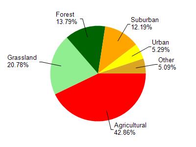
Henry Creek is located in the Upper Sugar River watershed which is 105.96 mi². Land use in the watershed is primarily agricultural (42.90%), grassland (20.80%) and a mix of forest (13.80%) and other uses (22.60%). This watershed has 183.62 stream miles, 151.49 lake acres and 2,231.15 wetland acres.
Nonpoint Source Characteristics
This watershed is ranked High for runoff impacts on streams, Not Ranked for runoff impacts on lakes and High for runoff impacts on groundwater and therefore has an overall rank of High. This value can be used in ranking the watershed or individual waterbodies for grant funding under state and county programs.However, all waters are affected by diffuse pollutant sources regardless of initial water quality. Applications for specific runoff projects under state or county grant programs may be pursued. For more information, go to surface water program grants.