Chippewa
No
No
Yes
Fish and Aquatic Life
Overview
Lake Hallie is a 79-acre oxbow lake formed by the Chippewa River. The lake is managed for both
warm and cold water fisheries. The lake experiences nuisance growths of elodea, curly-leaf
pondweed, algae and duckweed. Lake Hallie has a diverse aquatic plant community dominated by
elodea. Nuisance ~ l a n t growth likely could be controlled through reducing nutrient inputs and
harvesting rooted plants.
Lake Hallie currently has an average total phosphorus concentration of 30 micrograms per liter
(ug/l). This phosphorus concentration is relatively high for natural lakes. The potential for reducing
the phosphorus concentration through controlling watershed inputs should be evaluated. It is
important that best management practices be implemented through the Duncan Creek Priority
Watershed Project, whch will protect and improve water quality in Lake Hallie (Schreiber 1992).
Date 1996
Author Aquatic Biologist
Historical Description
Source: 1963, Surface Water Resources of Chippewa County Lake Hallie T28N, R9W, Sections 26 and 27
A soft water, drainage impoundment with a sizeable outlet to the Chippewa River. A large spring area on the northeast part of the lake contributes to the outlet flow. Its outlet has two water control structures of 10 feet and 5 feet owned by Mrs. George Reever. Considered to be a bass pan fish lake, it has largemouth bass, northern pike, bullheads, bluegills, black crappies, pumpkinseeds, white suckers, and carp. Management problems of the lake are its carp population and an occasional partial winterkill. Only migratory ducks and a few coots use the lake as a resting area. Muskrats are common. Private development consists of 11 cottages with one boat rental place. Public frontage and access consists of a town road bordering the lake outlet.
Surface Acres = 80.0, S.D.F. = 3.75, Maximum Depth = 14 feet
Date 1963
Author Surface Water Inventory Of Wisconsin
Impaired Waters
Hallie Lake (2150200) was placed on the impaired waters list for total phosphorus, Mercury, and sediment/total suspended solids. The pollutant of Mercury was delisted in 2008 and total phosphorus was delisted in 2014. This water was assessed during the 2016 listing cycle; total phosphorus and chlorophyll sample data were clearly below 2016 WisCALM listing thresholds for the Recreation use and Fish and Aquatic Life use. This water is still listed for sediment/total suspended solids and considered impaired.
Date 2015
Author Aaron Larson
Condition
Wisconsin has over 84,000 miles of streams, 15,000 lakes and milllions of acres of wetlands. Assessing the condition of this vast amount of water is challenging. The state's water monitoring program uses a media-based, cross-program approach to analyze water condition. An updated monitoring strategy (2015-2020) is now available. Compliance with Clean Water Act fishable, swimmable standards are located in the Executive Summary of Water Condition in 2018. See also the 'monitoring and projects' tab.
Reports
Recommendations
Land Acquisition
The Town of Hallie purchased approximately 22 acres of land on the north end of Lake Hallie. The parcel is an environmentally sensitive area, a major feature of the land is a wetland spring area. This area is a major cold-water source for the lake and provides a unique riparian buffer for several hundred feet of shoreline. The area also provides an extensive area of riparian wildlife habitat.
Monitor Fish Tissue
Management Goals
Wisconsin's Water Quality Standards provide qualitative and quantitative goals for waters that are protective of Fishable, Swimmable conditions [Learn more]. Waters that do not meet water quality standards are considered impaired and restoration actions are planned and carried out until the water is once again fishable and swimmable
Management goals can include creation or implementation of a Total Maximum Daily Load analysis, a Nine Key Element Plan, or other restoration work, education and outreach and more. If specific recommendations exist for this water, they will be displayed below online.
Monitoring
Monitoring the condition of a river, stream, or lake includes gathering physical, chemical, biological, and habitat data. Comprehensive studies often gather all these parameters in great detail, while lighter assessment events will involve sampling physical, chemical and biological data such as macroinvertebrates. Aquatic macroinvertebrates and fish communities integrate watershed or catchment condition, providing great insight into overall ecosystem health. Chemical and habitat parameters tell researchers more about human induced problems including contaminated runoff, point source dischargers, or habitat issues that foster or limit the potential of aquatic communities to thrive in a given area. Wisconsin's Water Monitoring Strategy was recenty updated.
Grants and Management Projects
Monitoring Projects
| WBIC | Official Waterbody Name | Station ID | Station Name | Earliest Fieldwork Date | Latest Fieldwork Date | View Station | View Data |
|---|
| 2150200 | Lake Hallie, Lake Hallie 2 | 093155 | Lake Hallie - Center Of Lake - Deep Hole | 9/3/1997 | 4/22/2026 | Map | Data |
| 2150200 | Lake Hallie, Lake Hallie 2 | 10001975 | Hallie Lake | 8/29/2000 | 6/23/2022 | Map | Data |
| 2150200 | Lake Hallie, Lake Hallie 2 | 10047543 | Lake Hallie Access | | | Map | Data |
| 2150200 | Lake Hallie, Lake Hallie 2 | 10048334 | Lake Hallie boat ramp | 5/2/2017 | 8/6/2025 | Map | Data |
| 2150200 | Lake Hallie, Lake Hallie 2 | 093115 | Hallie Lake at Deepest Point | 3/14/1991 | 4/22/2026 | Map | Data |
| 2150200 | Lake Hallie, Lake Hallie 2 | 10018603 | Lake Hallie -- Access | 7/29/2005 | 6/30/2025 | Map | Data |
| 2150200 | Lake Hallie, Lake Hallie 2 | 10055573 | Lake Hallie Spring | 7/8/2021 | 7/8/2021 | Map | Data |
| 2150200 | Lake Hallie, Lake Hallie 2 | 10014927 | Lake Hallie | | | Map | Data |
|
Watershed Characteristics
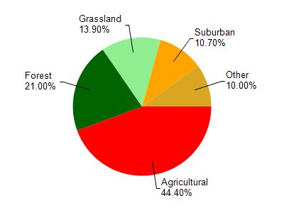
Lake Hallie, Lake Hallie 2 is located in the Duncan Creek watershed which is 191.44 mi². Land use in the watershed is primarily agricultural (44.40%), forest (21%) and a mix of grassland (13.90%) and other uses (20.70%). This watershed has 270.37 stream miles, 185.45 lake acres and 6,971.50 wetland acres.
Nonpoint Source Characteristics
This watershed is ranked Not Available for runoff impacts on streams, Not Available for runoff impacts on lakes and High for runoff impacts on groundwater and therefore has an overall rank of High. This value can be used in ranking the watershed or individual waterbodies for grant funding under state and county programs.However, all waters are affected by diffuse pollutant sources regardless of initial water quality. Applications for specific runoff projects under state or county grant programs may be pursued. For more information, go to surface water program grants.