Chippewa
No
No
Yes
Fish and Aquatic Life
Overview
These Duncan Creek impoundments are generally shallow, eutrophic, and support a warm water fishery. The impoundments have very high nutrient levels that result in nuisance growth of duckweed and excessive sedimentation that is filling in the impoundments. The impoundments are included in the Duncan Creek Priority Watershed Program, whch will control sources of polluted runoff. Reductions in sediment delivery will lengthen the useful life of the impoundments. It is unlikely that nutrient inputs can be reduced enough through the priority watershed project to result in decreased growth of duckweed (Schreiber 1992). The submergent aquatic plants of these impoundments are limited to species adapted to low light, eutrophic conditions and high siltation rates. These lakes also contain large mats of duckweed covering more than half the surface area at times. Physical removal of duckweed and harvesting of other aquatic plants are management options for control of nuisance levels of rooted aquatic plants (Borman) .
Date 1996
Author Aquatic Biologist
Historical Description
Source: 1963, Surface Water Resources of Chippewa County Lake Como T30N, R9W, Sections 5 and 6
A soft water, drainage impoundment on Duncan Creek. It has an 11-foot water control structure on its outlet owned by the Bloomer Farm Products Co. Its fish population consists of largemouth bass and pan fish. Muskrats are common and mallardsand blue-winged teal use the flowage area for nesting. There is a one-half acre City of Bloomer park on its east shore with facilities for swimming and access. There are three other undeveloped platted roads to the flowage for a total of 0.11 miles of public frontage. Private development consists of 34 homes.
Surface Acres = 97.9, S.D.F. = 3.76, Maximum Depth = 6 feet
Date 1963
Author Surface Water Inventory Of Wisconsin
Impaired Waters
Como Lake was recently evaluated during the ten-year period of 2009 through 2018 for results that were reported to the USEPA for the 2020 Clean Water Act condition report. The waterbody is considered impaired, or in poor condition for designated uses which include the quality of fish and aquatic life, recreational use, and public health and welfare (fish consumption and related). Pollutants or problems encountered during sampling (impairments) are determined based on water quality standards outlined in Wisconsin 2020 Consolidated Assessment and Listing Methodology (WisCALM). Assessment results show water conditions that are potentially harmful for Recreation use due to values for total phosphorus and chlorophyll that fall into the range expected for an aquatic community in poor health, therefore this water is listed as impaired.
Assessment results during the 2020 listing cycle show excess algal growth as a result of total phosphorus levels. Chlorophyll and total phosphorus data were assessed during the 2020 listing cycle. Both were too high for the Recreation designated use; however results for Aquatic Life were less clear and may exceed listing criteria. Based on the most updated information, this water was proposed for the impaired waters list in 2020.
Date 2019
Author Ashley Beranek
Condition
Wisconsin has over 84,000 miles of streams, 15,000 lakes and milllions of acres of wetlands. Assessing the condition of this vast amount of water is challenging. The state's water monitoring program uses a media-based, cross-program approach to analyze water condition. An updated monitoring strategy (2015-2020) is now available. Compliance with Clean Water Act fishable, swimmable standards are located in the Executive Summary of Water Condition in 2018. See also the 'monitoring and projects' tab.
Reports
Management Goals
Wisconsin's Water Quality Standards provide qualitative and quantitative goals for waters that are protective of Fishable, Swimmable conditions [Learn more]. Waters that do not meet water quality standards are considered impaired and restoration actions are planned and carried out until the water is once again fishable and swimmable
Management goals can include creation or implementation of a Total Maximum Daily Load analysis, a Nine Key Element Plan, or other restoration work, education and outreach and more. If specific recommendations exist for this water, they will be displayed below online.
Monitoring
Monitoring the condition of a river, stream, or lake includes gathering physical, chemical, biological, and habitat data. Comprehensive studies often gather all these parameters in great detail, while lighter assessment events will involve sampling physical, chemical and biological data such as macroinvertebrates. Aquatic macroinvertebrates and fish communities integrate watershed or catchment condition, providing great insight into overall ecosystem health. Chemical and habitat parameters tell researchers more about human induced problems including contaminated runoff, point source dischargers, or habitat issues that foster or limit the potential of aquatic communities to thrive in a given area. Wisconsin's Water Monitoring Strategy was recenty updated.
Grants and Management Projects
Monitoring Projects
| WBIC | Official Waterbody Name | Station ID | Station Name | Earliest Fieldwork Date | Latest Fieldwork Date | View Station | View Data |
|---|
| 2152100 | Como Lake (Bloomer Mill Pond) | 10007557 | Como Lake | 6/11/1991 | 8/19/2017 | Map | Data |
| 2152100 | Como Lake (Bloomer Mill Pond) | 093154 | Lake Como - Center Of Lake | 6/29/2006 | 9/5/2006 | Map | Data |
| 2152100 | Como Lake (Bloomer Mill Pond) | 10016232 | Unnamed Creek at Mouth Of Unnamed Cr. And Duncancr. | 6/14/1995 | 6/14/1995 | Map | Data |
| 2152100 | Como Lake (Bloomer Mill Pond) | 10018400 | Lake Como -- Access at The End Of Vine St | | | Map | Data |
| 2152100 | Como Lake (Bloomer Mill Pond) | 093112 | Como Lake at Deepest Point | 3/14/1991 | 9/17/2019 | Map | Data |
|
Watershed Characteristics
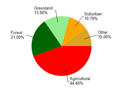
Como Lake (Bloomer Mill Pond) is located in the Duncan Creek watershed which is 191.44 mi². Land use in the watershed is primarily agricultural (44.40%), forest (21%) and a mix of grassland (13.90%) and other uses (20.70%). This watershed has 270.37 stream miles, 185.45 lake acres and 6,971.50 wetland acres.
Nonpoint Source Characteristics
This watershed is ranked Not Available for runoff impacts on streams, Not Available for runoff impacts on lakes and High for runoff impacts on groundwater and therefore has an overall rank of High. This value can be used in ranking the watershed or individual waterbodies for grant funding under state and county programs.However, all waters are affected by diffuse pollutant sources regardless of initial water quality. Applications for specific runoff projects under state or county grant programs may be pursued. For more information, go to surface water program grants.