Iowa
No
No
Yes
Fish and Aquatic Life
Overview
Ludden Lake is an impoundment on the Mineral Point Branch near Mineral Point. We have no water quality data for the lake, though we assume water quality to be poor and similar to that of other impoundments in the driftless area of southwestern Wisconsin (Marshall, 1988). Use of the lake is limited by poor public access. Property owners around the lake have formed a lake district as a first step in addressing water quality and lake use issues. The dam that forms the lake was repaired in 1993. No entity has taken responsibility for ownership of the dam at this writing, but that issue is expected to be resolved in 1994.
Date
Author Aquatic Biologist
Historical Description
Source: 1968, Surface Water Resources of Iowa County,WI: WI-DNR Ludden Lake, T5N, R2E, Section 36
Ludden Lake is an impoundment on the Mineral Point Branch and is located just west of the city of Mineral Point. It receives most of its water from the incoming streams and ground seepage. The lake was constructed by private enterprise in 1962. Most of the land area which drains into it is cleared for agricultural purposes. Runoff is generally heavily silt laden and probably contains large amounts of fertilizer from croplands. These nutrients create serious eutrophication problems for this lake. Presently there is an abundance of aquatic weeds present in the bay areas. With the generally shallow depth of basin its entire area can be expected to be overgrown by weeds in a few years unless some control measures are taken. The fishery consists mostly of fishes formally found in the stream. Basically it is managed for smallmouth bass but northern pike are also present. Panfish which are present include bluegills, rock bass, and brown bullheads. Forage and rough fish species include whitesuckers, buffalo, quillback, redhorse, common shiners, stoneroller minnows, hornyhead chubs, and hogsuckers. Game assets include muskrats with duck such as mallards, blue-winged teal, wood ducks and geese. There are no public lands here except for a 60-foot right-of-way which was allowed in the plat. However, because of its location on steep terrain there has been some difficulty in having it developed. There is virtually no public access at this time but the need should be considered urgent.
Surface Acres = 70, S.D.F. = (No aerial, No map), Maximum depth = 14 feet
Date 1968
Author Surface Water Inventory Of Wisconsin
Impaired Waters
Ludden Lake (WBIC 930700) was assessed during the 2018 listing cycle; new total phosphorus sample data overwhelmingly exceeded the 2018 WisCALM listing thresholds for the Recreation use and Fish and Aquatic Life use. Chlorophyll-a sample data also exceeded the REC and FAL use thresholds. This lake was proposed for total phosphorus listing in 2018.
Date 2017
Author Ashley Beranek
Condition
Wisconsin has over 84,000 miles of streams, 15,000 lakes and milllions of acres of wetlands. Assessing the condition of this vast amount of water is challenging. The state's water monitoring program uses a media-based, cross-program approach to analyze water condition. An updated monitoring strategy (2015-2020) is now available. Compliance with Clean Water Act fishable, swimmable standards are located in the Executive Summary of Water Condition in 2018. See also the 'monitoring and projects' tab.
Reports
Recommendations
Monitor or Propose 303(d) Listing
Ludden Lake should be added to the state�s 303(d) list of impaired waters because levels of total phosphorus and chlorophyll a exceed criteria and thresholds for shallow lowland lakes. The department should seek the aforementioned opportunities to work with partners to decrease soil and nutrient loss in the watershed upstream of Ludden Lake in order to improve water clarity, enhance macrophyte growth, and maintain the depth of the lake system which has been decreased over time due to sediment loads from upstream.
Partnership Project
DNR should seek opportunities to work collaboratively on projects which would benefit overall ecosystem health. Such opportunities include working with the Southwest Grasslands and Stream Conservation Area and Southwest Grasslands Bird Conservation Area. The department should work with groups to identify areas which would overlap as a priority for these programs, such as the upper Mineral Point watershed. These projects would also benefit Ludden Lake.
Management Goals
Wisconsin's Water Quality Standards provide qualitative and quantitative goals for waters that are protective of Fishable, Swimmable conditions [Learn more]. Waters that do not meet water quality standards are considered impaired and restoration actions are planned and carried out until the water is once again fishable and swimmable
Management goals can include creation or implementation of a Total Maximum Daily Load analysis, a Nine Key Element Plan, or other restoration work, education and outreach and more. If specific recommendations exist for this water, they will be displayed below online.
Monitoring
Monitoring the condition of a river, stream, or lake includes gathering physical, chemical, biological, and habitat data. Comprehensive studies often gather all these parameters in great detail, while lighter assessment events will involve sampling physical, chemical and biological data such as macroinvertebrates. Aquatic macroinvertebrates and fish communities integrate watershed or catchment condition, providing great insight into overall ecosystem health. Chemical and habitat parameters tell researchers more about human induced problems including contaminated runoff, point source dischargers, or habitat issues that foster or limit the potential of aquatic communities to thrive in a given area. Wisconsin's Water Monitoring Strategy was recenty updated.
Grants and Management Projects
Monitoring Projects
| WBIC | Official Waterbody Name | Station ID | Station Name | Earliest Fieldwork Date | Latest Fieldwork Date | View Station | View Data |
|---|
| 930700 | Ludden Lake | 253168 | Ludden Lake - Deep Hole | 4/6/1995 | 3/18/2024 | Map | Data |
| 930700 | Ludden Lake | 10002733 | Ludden Lake | 7/27/1999 | 3/3/2024 | Map | Data |
| 930700 | Ludden Lake | 10020047 | Ludden Lake -- Access | 5/10/2005 | 9/30/2013 | Map | Data |
|
Watershed Characteristics
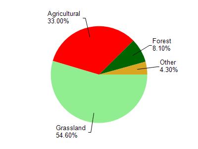
Ludden Lake is located in the Mineral Point and Sudan Branches watershed which is 108.26 mi². Land use in the watershed is primarily grassland (54.60%), agricultural (33%) and a mix of forest (8.10%) and other uses (4.30%). This watershed has 289.93 stream miles, 87.79 lake acres and 699.78 wetland acres.
Nonpoint Source Characteristics
This watershed is ranked Not Ranked for runoff impacts on streams, Not Ranked for runoff impacts on lakes and High for runoff impacts on groundwater and therefore has an overall rank of High. This value can be used in ranking the watershed or individual waterbodies for grant funding under state and county programs.However, all waters are affected by diffuse pollutant sources regardless of initial water quality. Applications for specific runoff projects under state or county grant programs may be pursued. For more information, go to surface water program grants.