Sauk
No
No
Yes
Fish and Aquatic Life
Overview
Lake Wisconsin is a large impoundment of the Wisconsin River created by the hydroelectric
dam at Prairie du Sac. It has a good sport fishery and is used extensively for recreation.
Because it is an impoundment, sedimentation and nutrient loading to the lake, and toxic
substance accumulation in bottom sediments, are concerns. The nutrient loading impacts the
lake by fostering algae blooms and affecting dissolved oxygen levels. Low levels of mercury,
and high levels of PCBs have been detected in sturgeon from the lake. A fish consumption
advisory for PCBs has been issued for the lake's sturgeon. Contaminated sediment sites exist
in Grubers Grove Bay, an arm of the lake near the Badger Army Ammunition Plant (BAAP).
Grubers Grove Bay received process waste water from the BAAP wastewater treatment
facility in the past. Sediment samples were found to have extremely high mercury
concentrations as well as high levels of lead and ammonia. In response to this, a major
dredging project was conducted to remove the contaminated sediment. There are plans to
restore the aquatic habitat in the Bay through the planting of rooted aquatic plants and
shoreline trees as well as fish crib deployment.
The Harmony Grove Lake Protection and Rehabilitation District recently received a Lake
Planning Grant to conduct a sediment study on the sediment in the bay. Harmony Grove Bay
is located on the Columbia County side of Lake Wisconsin north of Pine Bluff.
Wisconsin Power & Light Company, owner of the Prairie Du Sac Dam, as part of the Federal
Energy Regulatory Commission (FERC) relicensing process conducted water quality, algal,
fisheries and sediment contaminant studies during 1992. Continuous dissolved oxygen
monitoring at the dam tailrace showed the water quality standard of 5 mg/l was violated more
than half of July, a good portion of August and a few days in September, 1992. The worst
two-day period occurred July 27-28, when the maximum dissolved oxygen was 3.6 mg/l, the
minimum 1.7 mg/l. The suggested cause of the problem is a combination of the existence of
the dam and the high nutrient loads in the river. This leads to excessive algae growth in Lake
Wisconsin. When the algae die off, they deplete oxygen near the dam. Nutrient loading can
come from barnyard runoff and other forms of nonpoint source pollution. One dairy farmer
has been found to have multiple manure discharges to the lake. These sources of pollution
need to be addressed and curtailed to help improve the health of Lake Wisconsin. In addition,
fluctuating water levels below the Dells and Prairie du Sac dams remain a major concern on
the Wisconsin River. Fish passage at all dams on the Wisconsin River is important to the fish
communities and the river ecosystem as a whole.
In addition, long term database studies are in progress to look at walleye and sturgeon
reproduction. A no harvest 20-28ý slot regulation is proposed to improve fishing for larger
size walleye. Sturgeon harvest has been curtailed by implementing an alternating season size
limit of 50ý and 70ý. The lake sturgeon resource in the lake and river both up and downstream
needs to be carefully managed. This is a rare and long lived fish of which there are few
remaining fisheries in North America. Efforts are underway to expand the fishery upstream to
its original home range. Pollution had eliminated it upstream from the Kilbourn Dam at
Wisconsin Dells. A significant shovelnose sturgeon fishery also can be found in the lower
Wisconsin River below the Prairie du Sac dam. In addition, it is imperative to continue to
monitor the walleye population.
Date 2002
Author Aquatic Biologist
Historical Description
Lake Wisconsin is a large impoundment of the Wisconsin River created by the
hydroelectric dam at Prairie Du Sac. The lake is eutrophic (WDNR, 1991). It has a
good sport fishery and is used extensively for recreation. Because it is an impoundment,
sedimentation and nutrient loading to the lake, and toxic substance accumulation in
bottom sediments, are concerns. Low levels of mercury, and high levels of PCBs have
been detected in sturgeon from the lake (WDNR, 1991). A fish consumption advisory
for PCBs has been issued for the lake's sturgeon (WDNR, 1991). Sensitive areas were
identified in the lake during summer and fall of 1991 and a report is underway (Sesing,
1991-1992). The city of Portage moved its municipal discharge from the Fox River to
the Wisconsin River just above Lake Wisconsin. A 1985 study found no adverse impacts
on lake water quality due to the Portage discharge (Marshall, 1985). Contaminated
sediment sites exist in Grubers Bay, an arm of the lake near the Badger Army
Ammunition Plant (BAAP) (WDNR, 1991). Grubers Bay received water for the BAAP
wastewater treatment facility in the past. Wisconsin Power & Light, owner of the Prairie
Du Sac dam, has put together a "comprehensive water quality plan." The plan will look
at water chemistry, chlorophyll a, sediment, phytoplankton and zooplankton, benthic
macroinvertebrales, and aquatic plants in Lake Wisconsin. Data will be provided to the
DNR (Water Regulation and Zoning, 1993).
Wisconsin Power & Light Company, as part of the Federal Enera Regulatory
Commission (FERC) relicensing process conducted water quality, algal. fisheries and
sediment contaminant studies during 1992. Continuous dissolved oxygen monitoring at
the dam tailrace showed the water quality standard of 5 mgll was violated more than
half of July, a good portion of August and a few days in September, 1992. The worst
two-day period occurred July 27-28, when the maximum dissolved oxygen was 3.6 mgll,
the minimum 1.7 mgll. The suggested cause of the problem is a combination of the
existence of the danr and the high nutrient loads in the river. This leads to excessive
algae growth in Lake Wisconsin. Wlen the algae die off, they deplete oxygen near the
dam.
Date 1994
Author Surface Water Inventory Of Wisconsin
Historical Description
Source: 1965, Surface Water Resources of Columbia County (Lake)Wisconsin, T10, 11N, R7, 8E,
A major impoundment of the Wisconsin River in southern Wisconsin in 1914. The lake is maintained by a dam of 38-foot head owned by the Wisconsin Power Light Company. The water is brown and moderately fertile. Largemouth bass, panfish and walleye are most common in the fishery. Other species contributing to the catch are muskellunge and northern pike and sturgeon. This lake is the most southerly lake in Wisconsin having a sturgeon population, and one of only a few. Use problems are weeds, algae, carp, and pollution. The shallow bays and backwaters are subject to winterkill during severe winters. This situation amplifies the pollution problem and the surviving fish often have a disagreeable flavor that lasts until the spring thaw. Public access is provided at many sites, and numerous commercial facilities provide additional use opportunities. Unique access and fishing situations are provided by roads which cross arms of the impoundment. Also, it is crossed by one of the few remaining inland ferries. Nearly one thousand acres of lowland marsh adjoin the lake. Waterfowl are numerous, important visitors year-round. In winter one may observe American eagles below the dam at Prairie du Sac.
Surface Acres = 9,000, S.D.F. = 4.38, Maximum Depth = 24 feet
Date 1965
Author Surface Water Inventory Of Wisconsin
Recommendations
Monitor Water Quality or Sediment
Follow-up monitoring after sediment cleanup in Gruber's Grove Mercury site.
Land Acquisition
The Town of Merrimac will purchase the Clingman Property on Lake Wisconsin in the County of Sauk (approx. 15.1 acres).
Land Acquisition
The Town of Lodi proposes to acquire 8.5 acres of land in the Okee Bay area of Lake Wisconsin for recreational opportunities and lake protection.
Monitor Fish Tissue
Confirm FCA: IW listed from pre-year 2000 FCA data
Rivers Planning Grant
Lake Wisconsin Alliance will undertake a River Planning Grant project that will expand outreach and education of Lake Wisconsin natural and recreational resources, and lake water quality issues. The goal is to increase membership, provide identity to the LWA, and inform citizens living within the Lake Wisconsin watershed. Deliverables: 1. The Lake Wisconsin Alliance technical advisory team will provide action items to LWA members to help attain goals and objectives to protect and enhance L. Wisconsin. 2. Communicate the LWA mission and organizational roles through brochures and website development. 3. Develop a logo to give the alliance identity. 4. Website membership development to assist in expansion of membership, and develop a calendar of activities hosted by the alliance. 5. Host workshops and seminars to educate the public on lake water quality and strategies that help protect/enhance lake water quality.
Management Goals
Wisconsin's Water Quality Standards provide qualitative and quantitative goals for waters that are protective of Fishable, Swimmable conditions [Learn more]. Waters that do not meet water quality standards are considered impaired and restoration actions are planned and carried out until the water is once again fishable and swimmable
Management goals can include creation or implementation of a Total Maximum Daily Load analysis, a Nine Key Element Plan, or other restoration work, education and outreach and more. If specific recommendations exist for this water, they will be displayed below online.
Monitoring
Monitoring the condition of a river, stream, or lake includes gathering physical, chemical, biological, and habitat data. Comprehensive studies often gather all these parameters in great detail, while lighter assessment events will involve sampling physical, chemical and biological data such as macroinvertebrates. Aquatic macroinvertebrates and fish communities integrate watershed or catchment condition, providing great insight into overall ecosystem health. Chemical and habitat parameters tell researchers more about human induced problems including contaminated runoff, point source dischargers, or habitat issues that foster or limit the potential of aquatic communities to thrive in a given area. Wisconsin's Water Monitoring Strategy was recenty updated.
Grants and Management Projects
Monitoring Projects
| WBIC | Official Waterbody Name | Station ID | Station Name | Earliest Fieldwork Date | Latest Fieldwork Date | View Station | View Data |
|---|
| 1260600 | Lake Wisconsin | 573090 | Wisconsin River - Lake Wisconsin - Gruber's Bay | 11/5/1998 | 11/5/1998 | Map | Data |
| 1260600 | Lake Wisconsin | 573147 | Wisconsin River - Gruber'S Grove Wisconsin River | 2/14/2003 | 2/14/2003 | Map | Data |
| 1260600 | Lake Wisconsin | 573154 | Wisconsin River - Gruber'S Grove Wisconsin River | 2/17/2003 | 2/17/2003 | Map | Data |
| 1260600 | Lake Wisconsin | 10017167 | Lake Wisconsin - Gruber'S Grove Bay G07b | 2/22/2007 | 2/22/2007 | Map | Data |
| 1260600 | Lake Wisconsin | 573145 | Wisconsin River - Gruber'S Grove Wisconsin River | 2/14/2003 | 2/14/2003 | Map | Data |
| 1260600 | Lake Wisconsin | 10029823 | Wisconsin River - Grubers Grove Bay Lake WIsconsin | 2/12/2009 | 2/12/2009 | Map | Data |
| 1260600 | Lake Wisconsin | 10007820 | Lake Wisconsin | 7/9/1992 | 6/5/2021 | Map | Data |
| 1260600 | Lake Wisconsin | 10029819 | Wisconsin River - Grubers Grove Wisconsin River #36 | 2/11/2009 | 2/11/2009 | Map | Data |
| 1260600 | Lake Wisconsin | 573152 | Wisconsin River - Gruber'S Grove Wisconsin River | 2/17/2003 | 2/17/2003 | Map | Data |
| 1260600 | Lake Wisconsin | 573092 | Wisconsin River - Lake Wisconsin - Gruber's Bay | 11/5/1998 | 11/5/1998 | Map | Data |
| 1260600 | Lake Wisconsin | 573135 | Wisconsin River - Gruber'S Grove Wisconsin River | 2/14/2003 | 2/14/2003 | Map | Data |
| 1260600 | Lake Wisconsin | 10017166 | Lake Wisconsin - Gruber'S Grove Bay G03a | 2/22/2007 | 2/22/2007 | Map | Data |
| 1260600 | Lake Wisconsin | 573149 | Wisconsin River - Gruber'S Grove Wisconsin River | 2/14/2003 | 2/14/2003 | Map | Data |
| 1260600 | Lake Wisconsin | 10029814 | Wisconsin River - Grubers Grove Wisconsin River #19 | 2/10/2009 | 2/10/2009 | Map | Data |
| 1260600 | Lake Wisconsin | 573153 | Wisconsin River - Gruber'S Grove Wisconsin River | 2/17/2003 | 2/17/2003 | Map | Data |
| 1260600 | Lake Wisconsin | 10017172 | Lake Wisconsin - Gruber'S Grove Bay G27b | 2/22/2007 | 2/22/2007 | Map | Data |
| 1260600 | Lake Wisconsin | 573155 | Wisconsin River - Gruber'S Grove Wisconsin River | 2/14/2003 | 2/14/2003 | Map | Data |
| 1260600 | Lake Wisconsin | 573089 | Wisconsin River - Lake Wisconsin - Gruber's Bay | 11/5/1998 | 11/5/1998 | Map | Data |
| 1260600 | Lake Wisconsin | 573138 | Wisconsin River - Gruber'S Grove Wisconsin River | 2/14/2003 | 7/22/2008 | Map | Data |
| 1260600 | Lake Wisconsin | 10017173 | Lake Wisconsin - Gruber'S Grove Bay G31b | 2/22/2007 | 2/22/2007 | Map | Data |
| 1260600 | Lake Wisconsin | 10041723 | Lake Wisconsin Access - Off Waters Edge Way | | | Map | Data |
| 1260600 | Lake Wisconsin | 573151 | Wisconsin River - Gruber'S Grove Wisconsin River | 2/17/2003 | 2/17/2003 | Map | Data |
| 1260600 | Lake Wisconsin | 573140 | Wisconsin River - Gruber'S Grove Wisconsin River | 2/14/2003 | 2/14/2003 | Map | Data |
| 1260600 | Lake Wisconsin | 573091 | Wisconsin River - Lake Wisconsin - Gruber's Bay | 11/5/1998 | 11/5/1998 | Map | Data |
| 1260600 | Lake Wisconsin | 10029815 | Wisconsin River - Grubers Grove Wisconsin River #21 | 2/11/2009 | 2/11/2009 | Map | Data |
| 1260600 | Lake Wisconsin | 573146 | Wisconsin River - Gruber'S Grove Wisconsin River | 2/14/2003 | 2/14/2003 | Map | Data |
| 1260600 | Lake Wisconsin | 10029817 | Wisconsin River - Grubers Grove Wisconsin River #33 | 2/12/2009 | 2/12/2009 | Map | Data |
| 1260600 | Lake Wisconsin | 573157 | Wisconsin River - Gruber'S Grove Wisconsin River | 2/17/2003 | 2/17/2003 | Map | Data |
| 1260600 | Lake Wisconsin | 10029818 | Wisconsin River - Grubers Grove Wisconsin River #34 | 2/11/2009 | 2/11/2009 | Map | Data |
| 1260600 | Lake Wisconsin | 573139 | Wisconsin River - Gruber'S Grove Wisconsin River | 2/14/2003 | 5/22/2012 | Map | Data |
| 1260600 | Lake Wisconsin | 573136 | Wisconsin River - Gruber'S Grove Wisconsin River | 2/14/2003 | 2/14/2003 | Map | Data |
| 1260600 | Lake Wisconsin | 10029812 | Wisconsin River - Grubers Grove Wisconsin River #6 | 2/10/2009 | 2/10/2009 | Map | Data |
| 1260600 | Lake Wisconsin | 573137 | Wisconsin River - Gruber'S Grove Wisconsin River | 2/14/2003 | 2/14/2003 | Map | Data |
| 1260600 | Lake Wisconsin | 10029821 | Wisconsin River - Grubers Grove Bay Lake Wisconsin | 2/12/2009 | 2/12/2009 | Map | Data |
| 1260600 | Lake Wisconsin | 573144 | Wisconsin River - Gruber'S Grove Wisconsin River | 2/14/2003 | 2/14/2003 | Map | Data |
| 1260600 | Lake Wisconsin | 10017174 | Lake Wisconsin - Gruber'S Grove Bay G35c | 2/22/2007 | 2/22/2007 | Map | Data |
| 1260600 | Lake Wisconsin | 573142 | Wisconsin River - Gruber'S Grove Wisconsin River | 2/14/2003 | 2/14/2003 | Map | Data |
| 1260600 | Lake Wisconsin | 573150 | Wisconsin River - Gruber'S Grove Wisconsin River | 2/14/2003 | 2/14/2003 | Map | Data |
| 1260600 | Lake Wisconsin | 10017170 | Lake Wisconsin - Gruber'S Grove Bay G19c | 2/22/2007 | 2/22/2007 | Map | Data |
| 1260600 | Lake Wisconsin | 10017171 | Lake Wisconsin - Gruber'S Grove Bay G23a | 2/22/2007 | 2/22/2007 | Map | Data |
| 1260600 | Lake Wisconsin | 10029813 | Wisconsin River - Grubers Grove Wisconsin River #9 | 2/10/2009 | 2/10/2009 | Map | Data |
| 1260600 | Lake Wisconsin | 573143 | Wisconsin River - Gruber'S Grove Wisconsin River | 2/14/2003 | 2/14/2003 | Map | Data |
| 1260600 | Lake Wisconsin | 573156 | Wisconsin River - Gruber'S Grove Wisconsin River | 2/17/2003 | 2/17/2003 | Map | Data |
| 1260600 | Lake Wisconsin | 10017169 | Lake Wisconsin - Gruber'S Grove Bay G15a | 2/22/2007 | 2/22/2007 | Map | Data |
| 1260600 | Lake Wisconsin | 10029822 | Wisconsin River - Grubers Grove Bay Lake Wisconsin | 2/12/2009 | 2/12/2009 | Map | Data |
| 1260600 | Lake Wisconsin | 10029820 | Wisconsin River - Grubers Grove Bay Lake Wisconsin | 2/12/2009 | 2/12/2009 | Map | Data |
| 1260600 | Lake Wisconsin | 573148 | Wisconsin River - Gruber'S Grove Wisconsin River | 2/14/2003 | 2/14/2003 | Map | Data |
| 1260600 | Lake Wisconsin | 10029816 | Wisconsin River - Grubers Grove Wisconsin River #26 | 2/11/2009 | 2/11/2009 | Map | Data |
| 1260600 | Lake Wisconsin | 573141 | Wisconsin River - Gruber'S Grove Wisconsin River | 2/14/2003 | 2/14/2003 | Map | Data |
| 1260600 | Lake Wisconsin | 10017168 | Lake Wisconsin - Gruber'S Grove Bay G11c | 2/22/2007 | 2/22/2007 | Map | Data |
|
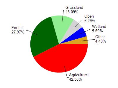
Watershed Characteristics
Lake Wisconsin is located in the Lake Wisconsin watershed which is 214.96 mi². Land use in the watershed is primarily agricultural (42.60%), forest (28%) and a mix of grassland (13.10%) and other uses (16.40%). This watershed has 299.58 stream miles, 521.55 lake acres and 6,644.90 wetland acres.
Nonpoint Source Characteristics
This watershed is ranked Medium for runoff impacts on streams, Low for runoff impacts on lakes and High for runoff impacts on groundwater and therefore has an overall rank of High. This value can be used in ranking the watershed or individual waterbodies for grant funding under state and county programs.However, all waters are affected by diffuse pollutant sources regardless of initial water quality. Applications for specific runoff projects under state or county grant programs may be pursued. For more information, go to surface water program grants.