Shawano
No
No
Yes
Fish and Aquatic Life
Overview
Shawano Lake is located in east central Wisconsin in Shawano County. The 6,178 acre lake has a 74 square mile watershed within the Wolf River Basin. This impounded drainage lake is relatively shallow for its size, with a maximum depth of 40 feet. The City of Shawano; Village of Cecil; Towns of Wescott, Washington, and Richmond are located adjacent to the lake. The Shawano Lake watershed is located predominantly in Shawano County, but extends into Menominee and Oconto Counties.
Date 2010
Author Mary Gansberg
Historical Description
Source: 1968, Surface Water Resources of Shawano County
Shawano Lake, T26N, R16E, Section 22
Surface Acres = 6,178.1, S.D.F. =1.49, Maximum Depth = 42 feet
A hard water drainage lake having slightly alkaline, clear water of moderate transparency. Sand is the predominant littoral material (88 percent) with muck and some rubble. Rock bars are found with the lake basin and not at the shoreline. The shoreline is predominantly upland (90 percent) with the balance being wetland shrub and meadow along with some conifers, hardwoods and marsh. Northern pike, walleye and largemouth bass are the predominant gamefish species with muskellunge being caught on occasion. Other fish species present are perch, bluegill, black crappie, rock bass, pumpkinseed, black bullhead, longnose gar, and bowfin along with a variety of minnow species. Carp and lake sturgeon are also present. Mallard, black duck, blue-winged teal and wood duck use this lake as a nesting site. This lake is important to migrating waterfowl with canvasback, redhead, scaup, ringneck, bufflehead, goldeneye, widgeon, mallard, black-duck, blue-winged teal, green-winged teal, wood duck, coot, swan, blue, snow and Canada geese using this lake on their spring and fall migrations. The once significant muskrat population has been declining and is approaching the point of being insignificant. A county park and village park afford opportunities for camping, swimming and boat launching with parking. Fees are requested for the launching of boats. In addition there are three private landings, with parking facilities available for a nominal fee. Several access roads with parking are also available and there are numerous access points available without nearby parking. The navigable water type of access is also present by navigating either the outlet orthe major inlet stream, Loon Creek. Commercial facilities consist of 33 resorts, 4 trailer courts, 2 motels, and 2 marinas, and 11 boat rentals. Public and semi-public facilities are two public campgrounds and an organizational camp (boy's). Private dwellings fronting on the shoreline number 793. Back lot developments would raise the number of dwellings substantially. A water control structure located on the Wolf River at the paper mill dam in Shawano influences the water levels on this lake to some degree. The outlet stream is freely navigable affording an opportunity for movement of boats between the Wolf River Ponds, Wolf River and Shawano Lake. The dense growths of submerged aquatic vegetation, particularly in the shallow western portion of the basin, is a problem to the users of this lake. Dense Algae blooms are also a use problem. Although the western portion of this lake basin that have comparable situations. A factor in the lake's high biological productivity is its shallow character and extensive littoral areas. The average depth is approximately 6 feet.
Date 1968
Author Surface Water Inventory Of Wisconsin
General Condition
Shawano Lake is heavily used year-round for recreation and is economically significant to Shawano County. In general, Shawano Lake has relatively good water quality for a shallow drainage lake. The lake tends to have enriched sediment and relatively shallow depths which results in good growing conditions and light penetration for aquatic plant growth in more than half of the lake. In addition to the natural complexity associated with a relatively shallow lake, Shawano Lake's ecosystem appears to be in flux due to the introduction of many non-native aquatic organisms including zebra mussels, Eurasian water milfoil, and curlyleaf pondweed.
Water quality in Shawano Lake is dependent upon internal and external factors. The watershed, as a whole, contributes about half of the annual phosphorus load. This includes direct runoff and loading from tributaries. Land use practices near shore and within the watershed are probably the most manageable aspect in terms of phosphorus reduction and reduction of runoff and improved infiltration. It is also important to address land management issues further out in the watershed including reducing phosphorus inputs to groundwater. The greatest single contributor of total phosphorus to Shawano Lake is internal sediment release; this is difficult and expensive to directly manage. The invasive aquatic plant curlyleaf pondweed (P. crispus) is abundant in Shawano Lake. A large pulse of phosphorus is released after P. crispus dies off in June, which then becomes available for algae to utilize.
Date 2010
Author Mary Gansberg
Impaired Waters
Shawano Lake (322800) was assessed during the 2016 listing cycle; total phosphorus and chlorophyll sample data exceeded 2016 WisCALM listing thresholds for the Recreation use, but did not exceed Fish and Aquatic Life thresholds.
Date 2015
Author Aaron Larson
Condition
Wisconsin has over 84,000 miles of streams, 15,000 lakes and milllions of acres of wetlands. Assessing the condition of this vast amount of water is challenging. The state's water monitoring program uses a media-based, cross-program approach to analyze water condition. An updated monitoring strategy (2015-2020) is now available. Compliance with Clean Water Act fishable, swimmable standards are located in the Executive Summary of Water Condition in 2018. See also the 'monitoring and projects' tab.
Reports
Recommendations
Diagnostic/Feasibility Assessment
Shawano County proposes to conduct a diagnostic and feasibility study to better understand the ecosystem of Shawano Lake and its watershed, to educate and inform the public about this ecosystem, to establish a management partnership to identify appropriate management options, and to implement a management strategy.
Aquatic Invasive Species Plan
SHAWANO COUNTY: Shawano County leyogonimus Parasite Study Phase 2
Aquatic Invasives Research
SHAWANO COUNTY: Shawano Lake Leyogonimus Parasite Study
Monitor Fish Tissue
Monitor Water Quality or Sediment
DELIST. Remove Mercury listing based on lack of FC advice. Remove Total Phosphours and Excess Algal Growth listings based on new TP and Chl-a data.
I�d like to keep this one listed. This one has been teetering on the threshold for a while and I�m working with the lake group on addressing some of the watershed issues. I�m afraid if they see it is no longer listed, they will quit making strides.
Restore Wetlands
Restore key wetlands to improve and protect water quality. Restore wetlands for lake and stream water quality protection. Increase funding to Counties to restore wetlands.
Easement/Buffer
Establish riparian buffers to protect water quality. Re-establish shoreland buffers around lakes, streams, and drainage ways in the watershed to decrease pollutant loads and to provide habitat for aquatic wildlife.
Lake Management Plan Implementation
Management recommendations and an implementation strategy were developed for Shawano Lake and its watershed. In summary the recommendations from this plan include: monitoring water quality and invasive species, harvesting and chemical treatment of aquatic plants, implementation of best management practices in the watershed and along the shores, and extensive information and education efforts. This plan was recently adopted by the local management units and should be implemented over the next few years.
Management Goals
Wisconsin's Water Quality Standards provide qualitative and quantitative goals for waters that are protective of Fishable, Swimmable conditions [Learn more]. Waters that do not meet water quality standards are considered impaired and restoration actions are planned and carried out until the water is once again fishable and swimmable
Management goals can include creation or implementation of a Total Maximum Daily Load analysis, a Nine Key Element Plan, or other restoration work, education and outreach and more. If specific recommendations exist for this water, they will be displayed below online.
Monitoring
Monitoring the condition of a river, stream, or lake includes gathering physical, chemical, biological, and habitat data. Comprehensive studies often gather all these parameters in great detail, while lighter assessment events will involve sampling physical, chemical and biological data such as macroinvertebrates. Aquatic macroinvertebrates and fish communities integrate watershed or catchment condition, providing great insight into overall ecosystem health. Chemical and habitat parameters tell researchers more about human induced problems including contaminated runoff, point source dischargers, or habitat issues that foster or limit the potential of aquatic communities to thrive in a given area. Wisconsin's Water Monitoring Strategy was recenty updated.
Grants and Management Projects
Monitoring Projects
| WBIC | Official Waterbody Name | Station ID | Station Name | Earliest Fieldwork Date | Latest Fieldwork Date | View Station | View Data |
|---|
| 322800 | Shawano Lake | 10005729 | Shawano Lake | 5/1/1994 | 7/7/2020 | Map | Data |
| 322800 | Shawano Lake | 10043294 | Shawano Lake East Basin | | | Map | Data |
| 322800 | Shawano Lake | 10044690 | Shawano Lake - E (Herbicide Monitoring Site 5) | 5/26/2016 | 7/8/2019 | Map | Data |
| 322800 | Shawano Lake | 10037496 | Shawano Lake -- Shawano County Park Access | 5/7/2011 | 7/4/2020 | Map | Data |
| 322800 | Shawano Lake | 10019266 | Shawano Lake -- Access Off Hwy H Nr Sunset Circle | 7/3/2002 | 6/10/2025 | Map | Data |
| 322800 | Shawano Lake | 10019394 | Shawano Lake -- Access Nr Stark Rd And Washington Lake | 6/18/2011 | 10/20/2023 | Map | Data |
| 322800 | Shawano Lake | 10019841 | Shawano Lake -- Cedar Court Carry-in | 8/4/2007 | 6/7/2023 | Map | Data |
| 322800 | Shawano Lake | 10042086 | Shawano Lake - Southwest Bay (Herbicide Monitoring Site 1) | 6/4/2014 | 6/7/2014 | Map | Data |
| 322800 | Shawano Lake | 593174 | Shawano Lake - Shawano Lake | | | Map | Data |
| 322800 | Shawano Lake | 10019677 | Shawano Lake -- Access Nr County HHH And Lake Dr | 6/3/2011 | 7/5/2015 | Map | Data |
| 322800 | Shawano Lake | 10042089 | Shawano Lake - Southwest Bay (Herbicide Monitoring Site 4) | 6/4/2014 | 6/7/2014 | Map | Data |
| 322800 | Shawano Lake | 10052738 | South Outlet Culvert by Cecil boat landing | 7/22/2019 | 7/26/2024 | Map | Data |
| 322800 | Shawano Lake | 10019391 | Shawano Lake -- Access Nr Swan Acre Dr | 7/6/2002 | 6/26/2025 | Map | Data |
| 322800 | Shawano Lake | 10019393 | Shawano Lake -- Cattau Beach Dr Access | 6/4/2011 | 8/31/2021 | Map | Data |
| 322800 | Shawano Lake | 593154 | Shawano Lake - Northwest Basin | 8/31/1999 | 6/28/2016 | Map | Data |
| 322800 | Shawano Lake | 10051838 | Township 0815 | 7/3/2018 | 10/2/2019 | Map | Data |
| 322800 | Shawano Lake | 593145 | Shawano Lake - East Central Part Of Lake | 8/11/1998 | 7/8/2019 | Map | Data |
| 322800 | Shawano Lake | 593153 | Shawano Lake - W Basin Betw. Island & Outlet | 8/31/1999 | 6/28/2016 | Map | Data |
| 322800 | Shawano Lake | 10019676 | Shawano Lake -- Access Nr County HHH And Maders Cir | 5/26/2008 | 6/7/2023 | Map | Data |
| 322800 | Shawano Lake | 10042087 | Shawano Lake - Southwest Bay (Herbicide Monitoring Site 2) | 6/4/2014 | 6/7/2014 | Map | Data |
| 322800 | Shawano Lake | 593072 | Shawano Lake - Deep Hole | 6/14/1988 | 5/22/2025 | Map | Data |
| 322800 | Shawano Lake | 10019397 | Shawano Lake -- Access Nr Freeborn St And Pickerel Creek | 7/24/2004 | 8/31/2021 | Map | Data |
| 322800 | Shawano Lake | 10042088 | Shawano Lake - Southwest Bay (Herbicide Monitoring Site 3) | 6/4/2014 | 6/7/2014 | Map | Data |
|
Watershed Characteristics
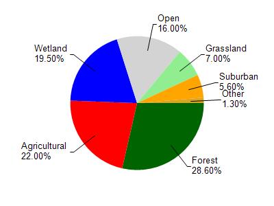
Shawano Lake is located in the Shawano Lake watershed which is 71.16 mi². Land use in the watershed is primarily forest (28.60%), agricultural (22%) and a mix of wetland (19.50%) and other uses (29.90%). This watershed has 76.28 stream miles, 7,438.74 lake acres and 7,573.91 wetland acres.
Nonpoint Source Characteristics
This watershed is ranked Not Ranked for runoff impacts on streams, High for runoff impacts on lakes and High for runoff impacts on groundwater and therefore has an overall rank of High. This value can be used in ranking the watershed or individual waterbodies for grant funding under state and county programs.This water is ranked High Lake for individual Lakes based on runoff problems and the likelihood of success from project implementation.