")
3.05 Miles
0 - 3.05
Cool-Cold Headwater, Cool-Warm Headwater
2021
Good
Sheboygan
Yes
No
No
Fish and Aquatic Life
Overview
La Budde Creek flows directly into the Mullet River. La Budde Creek is one of three streams in Sheboygan County where significant amounts of naturally reproduced trout are found. The stream obtains the majority of its flow from several seepage springs along its upper mile. The steam averages 8-feet in width, 10-inches in depth, and has a relatively low gradient of 5.6-feet of drop per mile. Management on the fishery area is aimed specifically at brook trout, which have a fair amount of natural reproduction in the headwaters of the stream. The native brook trout are supplemented with hatchery fish to provide additional recreational opportunities.
The La Budde Creek State Fisheries area is 426 acres in size and contains lowland brush and swamp hardwoods adjacent to the stream. Northern hardwoods, upland brush, and grassland are present in the upland areas of the property. This area is a transition between glacial moraine and clay till plain. Soil associations include the Hochheim-Theresa and Casco-Fox-Rodman associations.
Class II Trout Reach (RM 0-3.2) Start Mile: 0.01; End Mile: 3.05
This reach of the creek is classified as a Class II trout stream, and extends from its confluence with the Mullet River to Badger Road. Water quality is rated as good. The low gradient of the stream and some sedimentation from upstream agricultural runoff limit fish and aquatic life habitat.
Class I Trout Reach (RM 3.2-5.1) Start Mile: 3.05; End Mile: 6.96
This reach of LaBudde Creek originates as a series of small springs southwest of Rhine Center. The 1.9 mile segment is Class I trout stream and has good water quality for the entire reach. Stream improvements have upgraded the trout habitat and encouraged natural brook trout reproduction.
Date 2001
Author Aquatic Biologist
General Condition
Labudde Creek (WBIC 54800) from Badger Road to the headwaters was assessed during the 2018 listing cycle; new biological (fish Index of Biotic Integrity (IBI) scores) sample data were clearly below the 2018 WisCALM listing thresholds for the Fish and Aquatic Life use. This water was meeting this designated use and was not considered impaired.
Date 2017
Author Ashley Beranek
Condition
Wisconsin has over 84,000 miles of streams, 15,000 lakes and milllions of acres of wetlands. Assessing the condition of this vast amount of water is challenging. The state's water monitoring program uses a media-based, cross-program approach to analyze water condition. An updated monitoring strategy (2015-2020) is now available. Compliance with Clean Water Act fishable, swimmable standards are located in the Executive Summary of Water Condition in 2018. See also the 'monitoring and projects' tab.
Reports
Recommendations
Restore Wetlands
Work to restore wetlands and riparian buffers and establish permanent vegetative cover or best management practices on agricultural lands in the headwater areas of La Budde Creek.
Monitor and/or Protect Groundwater, Sourcewater
Identify and protect groundwater recharge areas for cold water segments of La Budde Creek.
Fish Management, Access
Secure resources to implement WDNR fisheries management activities to improve habitat in the cold water sections of LaBudde Creek.
Information and Education
Ensure that public property managers are aware of and have access to water quality and biological assessment data that exist for the LaBudde Creek Watershed.
Master Planning
Ensure that issues and recommendations from the 2010 Mullet River Watershed Plan are considered during master planning and annual property planning for the La Budde Creek Fisheries Property.
Management Goals
Wisconsin's Water Quality Standards provide qualitative and quantitative goals for waters that are protective of Fishable, Swimmable conditions [Learn more]. Waters that do not meet water quality standards are considered impaired and restoration actions are planned and carried out until the water is once again fishable and swimmable
Management goals can include creation or implementation of a Total Maximum Daily Load analysis, a Nine Key Element Plan, or other restoration work, education and outreach and more. If specific recommendations exist for this water, they will be displayed below online.
Monitoring
Monitoring the condition of a river, stream, or lake includes gathering physical, chemical, biological, and habitat data. Comprehensive studies often gather all these parameters in great detail, while lighter assessment events will involve sampling physical, chemical and biological data such as macroinvertebrates. Aquatic macroinvertebrates and fish communities integrate watershed or catchment condition, providing great insight into overall ecosystem health. Chemical and habitat parameters tell researchers more about human induced problems including contaminated runoff, point source dischargers, or habitat issues that foster or limit the potential of aquatic communities to thrive in a given area. Wisconsin's Water Monitoring Strategy was recenty updated.
Grants and Management Projects
Monitoring Projects
| WBIC | Official Waterbody Name | Station ID | Station Name | Earliest Fieldwork Date | Latest Fieldwork Date | View Station | View Data |
|---|
| 54800 | La Budde Creek | 10047462 | Wetland [ID 60423691253] | 10/11/2016 | 10/11/2016 | Map | Data |
| 54800 | La Budde Creek | 10009377 | Labudde Creek 1 Downstream Of Highview Road | | | Map | Data |
| 54800 | La Budde Creek | 603048 | La Budde Creek at Golf Course Road | 1/15/1975 | 12/16/1975 | Map | Data |
| 54800 | La Budde Creek | 10030854 | La Budde Creek 105m DS of Hwy 67 | 1/1/2015 | 1/1/2015 | Map | Data |
| 54800 | La Budde Creek | 603283 | La Budde Creek at Golf Course Rd and STH 67 | 5/15/1980 | 10/1/2014 | Map | Data |
| 54800 | La Budde Creek | 10030855 | La Budde Creek 105m DS of Badger Rd | | | Map | Data |
| 54800 | La Budde Creek | 10039290 | La Budde Creek at Hwy 67 | 8/29/2014 | 9/30/2015 | Map | Data |
|
Watershed Characteristics
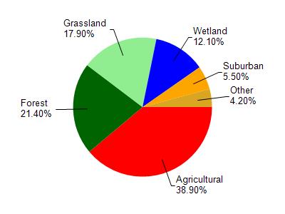
La Budde Creek is located in the Mullet River watershed which is 88.19 mi². Land use in the watershed is primarily agricultural (38.90%), forest (21.40%) and a mix of grassland (17.90%) and other uses (21.80%). This watershed has 97.54 stream miles, 789.87 lake acres and 6,609.38 wetland acres.
Nonpoint Source Characteristics
This watershed is ranked High for runoff impacts on streams, Not Ranked for runoff impacts on lakes and High for runoff impacts on groundwater and therefore has an overall rank of High. This value can be used in ranking the watershed or individual waterbodies for grant funding under state and county programs.However, all waters are affected by diffuse pollutant sources regardless of initial water quality. Applications for specific runoff projects under state or county grant programs may be pursued. For more information, go to surface water program grants.
Labudde Creek is considered a Cool-Cold Headwater, Cool-Warm Headwater under the state's Natural Community Determinations.
Natural communities (stream and lake natural communities) represent model results and DNR staff valiation processes that confirm or update predicted conditions based on flow and temperature modeling from historic and current landscape features and related variables. Predicated flow and temperatures for waters are associated predicated fish assemblages (communities). Biologists evaluate the model results against current survey data to determine if the modeled results are corect and whether biological indicators show water quaity degradation. This analysis is a core component of the state's resource management framework. Wisconsin's Riverine Natural Communities.
Cool (Warm-Transition) Headwaters are small, sometimes intermittent streams with cool to warm summer temperatures. Coldwater fishes are uncommon to absent, transitional fishes are abundant to common, and warm water fishes are common to uncommon. Headwater species are abundant to common, mainstem species are common to absent, and river species are absent.
Cool (Cold-Transition) Headwaters are small, usually perennial streams with cold to cool summer temperatures. Coldwater fishes are common to uncommon (<10 per 100 m), transitional fishes are abundant to common, and warm water fishes are uncommon to absent. Headwater species are abundant to common, mainstem species are common to absent, and river species are absent.