Sheboygan
No
No
Yes
Fish and Aquatic Life
Overview
JETZERS LAKE
T16N, R22E, Section 28 (1, 2); Sheboygan County
Surface Acres = 15, S.D.F. = 1.45, Maximum Depth = 42 feet
Jetzers Lake is located within a 146-acre direct drainage basin. The lake encompasses approximately 15 acres of surface water with a maximum depth of 42 feet, an average depth of 20 feet and a lake volume of 300-acre feet. The dominant land uses within the Jetzers Lake subwatershed are agriculture and forest
(Olson and Helsel 1997). Jetzers Lake has been classified as a nutrient rich eutrophic lake with relatively poor water clarity (Olson and Helsel 1997). The lake receives heavy fishing pressure from the nearby communities of Howards Grove and Sheboygan (Nelson 1998). Trophic State indices range between 50 and 70 (Figure 31).
Water Quality Survey
Olson and Helsel (1997) estimated the annual total phosphorus load to the lake from the watershed and deposition at 150 lbs/yr. They determined that agriculture is estimated to contribute the greatest percentage of the approximately 20% external phosphorus load to the lake. Olson and Helsel (1997) used models to estimate pre-development phosphorus load of 14 lbs/yr assuming only the direct watershed drained to the lake. The models indicate best management practices should be implemented throughout the entire watershed and an alum treatment conducted to achieve the greatest improvements in water quality. The duration of effectiveness of the alum treatment is related to both dose and watershed load of phosphorus (Olson and Helsel 1997). To be effective, direct watershed BMPs, at a minimum, need to be implemented prior to treatment with alum.
Fish Community Survey
Fish Management surveyed the fish community of Jetzers lake in spring, 1998 with fyke nets and electrofishing (Nelson 1998a). Northern pike were numerous, had a desirable size structure, and grew at average rates. Black crappie were over-abundant, had a poor size structure and were slow-growing. Bluegill were abundant, had a good to fair size structure and grew slower than the regional rate but, similar to the statewide rate.
Jetzers Lake has a long history of poor water quality from past and present agricultural contributions. Aluminum sulfate (alum) application has been recommended to reduce phosphorus levels along with controls on current phosphorus loading from the watershed. The lake has a long history of poor water quality and slow-growing panfish. A July 1954 survey of the lake described very green water color caused by an algae bloom with a 1 ft. secchi disc reading, indicating poor water clarity (pers. comm. John Nelson). A barnyard extended into the lake and low oxygen levels were found at the 10 ft. depth and deeper. A subsequent survey took place in July 1960. That survey included fish collection with a boom shocker. Agricultural pollution from a barnyard and pasturing around the lake was noted. It was also noted that “excess fertility causes algae blooms - caused by pasturing and barnyard drainage.” The author noted that “bluegill and black crappie appear to be stunted” and that there “may be a fair carp population.” Jetzers Lake was electrofished again in May 1975. No report was written but the data indicated that small crappies were abundant. The secchi disc reading was 2.5 feet.
Water quality has remained poor in Jetzers Lake. A July 21, 1997 water quality survey documented no oxygen present at the 10’ depth and a secchi disc reading of 1.3 feet. Further, phosphorus levels up to 910 micrograms/liter were reported in a June 10, 1994 preliminary draft of a Jetzers Lake Protection Plan. Phosphorus levels of 30 micrograms/liter or more are indicative of poor water quality lakes.
Date 2001
Author Aquatic Biologist
Overview
Bluegill
We caught 228 bluegill in fyke nets at a rate of 15.2/NN (Table 80). A total of 111 were caught with electrofishing gear at a rate of 277.5/hr.
The size structure of bluegill from the lake was fairly good with many of the bluegill in the 6.0” - 7.0” range (Figure 25). The fyke net sample ranged in size from 3.3” - 7.6” with a mean of 5.9” and a PSD of 61.7% which is considered very high compared to other lakes. The RSD7, or proportion over 7” long, was 4.3% which is low compared to many bluegill populations.
The growth rate of bluegill from Jetzers lake was below the regional average but, similar to the statewide average for that species (Table 80). The key to managing bluegill in the lake is to convert the high fertility of the lake to fish flesh. Water quality improvements are the key to improve energy transfer through the food chain.
Pumpkinseed Sunfish
Pumpkinseed sunfish were fairly common in the lake. We captured them at rates of 6.9/NN in fyke nets and 75.0/hr while electrofishing (Table 80). Pumpkinseed are generally common in waters which experience low oxygen conditions.
The size structure of pumpkinseed sunfish was very poor (Figure 26). Most of the fish were in the 4.4 - 4.9” range. They ranged in size from 3.2 - 6.0” with a mean of 4.7” and a PSD of 1.0%.
The growth of pumpkinseed was below the regional average and similar to the statewide average (Table 80). The pumpkinseed likely compete with bluegill for the same food resources and similar growth patterns would be expected as observed in this survey.
Yellow Bullhead
Both yellow and black bullhead were present but, yellow bullhead were the most common of the two species in both the fyke net and electrofishing samples. We caught 64 yellow bullhead in fyke nets at a rate of 4.3/NN (Table 78, page Error! Bookmark not defined.).
The yellow bullhead fyke net samples ranged in size from 5.1 - 10.6” with a mean of 8.2”. The bullheads could provide some good fishing opportunities for local anglers.
Other Species
The other species captured during the survey included green sunfish, yellow perch, white sucker, carp and golden shiner. White suckers were fairly common. We caught few carp though, several more were observed which avoided capture. Carp did not appear to be over-abundant and did not constitute a serious management problem.
The low number of yellow perch captured was unexpected. Yellow perch are normally a dominant species in waters, which experience low oxygen conditions. Perhaps predation by the abundant northern pike keeps the population at low levels.
The most serious management problem for Jetzers Lake is high phosphorus levels which foster heavy algal blooms and depress overall water quality. I recommend that we immediately explore and seek funding for a whole-lake treatment with aluminum sulfate (alum) to tie up much of the phosphorus load. Some runoff from cropped lands still contributes phosphorus to the lake yet, it is evident that resident phosphorus loads are very excessive and require immediate attention.
The fishery of Jetzers Lake is generally in fair to good condition. The slow growth of crappie will be difficult to alter. However, improvements in water quality may help to improve zooplankton populations and increase panfish growth. It may be desirable to attempt to establish a healthy fathead minnow population in the lake and physically remove some crappie from the lake.
Date 2001
Author Aquatic Biologist
Overview
The impacts of poor water quality on the fish community are many and significant at Jetzers Lake. The lake is susceptible to both winter and summer fish kills. The heavy algae blooms can cause poor quality flavor in the fish flesh. Also, the food chain is disrupted, affecting especially the quality of zooplankton populations that transfer food energy up the food chain to the fishes.
Therefore, the greatest management need for Jetzers Lake and its fishery is to improve and protect water quality. Fortunately, the lake has a very small watershed. The deep nature of the lake is also an attribute since is may be possible to apply aluminum sulfate (alum) to the lake to reduce the availability of phosphorus which would reduce the amount of algae production and improve the overall quality of the lake.
Jetzers Lake was stocked with several species of fish in 1993 following a major fish kill in March of that year. WDNR stocked 15,000 northern pike fry, 2,400 bluegill and 107 largemouth bass.
Electrofishing samples were collected from the lake in 1996, 1997 and 1998. I will discuss the 1998 sample in this report. That electrofishing took place on May 12, 1998 using a large boom shocker unit with two people netting fish after dusk. We also fished the lake with three fyke nets from March 26 through March 31, 1998
Northern pike were the most common gamefish in the samples (Table 78). Black crappie were the most common panfish. We captured a total of twelve species of fish.
Northern Pike
We captured 109 northern pike in fyke nets at a rate of 7.3/net night (NN). The population estimate for the lake was 119 pike or 7.9/acre with a standing crop of 294 lbs. or 19.6 lbs./acre.
The pike ranged in size from 10.0” - 32.1” (Figure 23). Females and males averaged 24.5” and 20.2”, respectively. Legal length fish (> 26”) made up 12.3% of the catch and included only females. The length mode peaked at the 20” - 21” length which represents largely age 3 and 4 fish.
The density and size distribution of northern pike in the lake was surprisingly good considering the small size of the lake and the intensity of the fishing activity. Forage is very abundant and the population should continue to expand under the current 26” minimum size limit. No further management specifically for northern pike is planned or needed at this point.
Largemouth Bass
We caught only 9 largemouth bass in fyke nets and one while electrofishing. In 1997 we caught 12 largemouth bass while electrofishing. The 1998 sample probably does not reflect the true abundance of largemouth bass in Jetzers Lake.
The lake has produced some large bass in the past and has potential to do so in the future. We caught bass up to 18.8” long in 1997 and 19.5” in 1998 during the surveys. Small bass were present though they may be highly vulnerable to predation by northern pike. No additional management is needed for largemouth bass in the lake beyond the current 14” minimum size limit.
Black Crappie
We caught 984 black crappie in fyke nets (65.6/NN) and 152 while electrofishing (380.0/hr) in 1998 (Table 79). I consider the population to be over-abundant as indicated by this and previous surveys.
In fyke net samples, the crappie ranged in size from 4.7” - 8.4” long with an average of 6.8” and a PSD of 1.9%. The very low PSD indicates a poorly structured fish population that is dominated by either a large year class of young fish or fish that are slow growing. In the case of Jetzers Lake, it indicates slow growth. The peak length mode was at 6.6” (Figure 24). The electrofishing data were similar with a mean length of 6.9” and a PSD of 1.3%.
Date 2001
Author Aquatic Biologist
Historical Description
Source: 1968, Surface Water Resources of Sheboygan County Jetzer Lake T16N, R22E, Section 28 (1, 2) Surface Acres = 14.9, S.D.F. = 1.45, Maximum Depth = 42 feet.
A small, spring-fed lake near the terminal moraine; small springs are on the north and southwest sides of the lake. The variable flow of the outlet to the Pigeon River is strongly influenced by annual precipitation. The bottom type in the littoral zone is predominately sand and clay. Excess fertility, causing moderate to heavy algae blooms, derived from barnyard drainage and pasturing around the lake, pose a major use problem. Some erosion is detectable mainly on the southern shoreline. The presence of carp and turbid water may threaten the game fishery. The fishery consists of largemouth bass, northern pike and panfish--bluegill and black crappie appearing stunted. Northern pike are stocked periodically. A cattail marsh on the east end of the lake is used by nesting mallards and teal--used very little during spring and fall migrations. One public access with parking, developed by Sheboygan County Conservation Association, and a boat livery are available to anglers.
Date 1968
Author Surface Water Inventory Of Wisconsin
Condition
Wisconsin has over 84,000 miles of streams, 15,000 lakes and milllions of acres of wetlands. Assessing the condition of this vast amount of water is challenging. The state's water monitoring program uses a media-based, cross-program approach to analyze water condition. An updated monitoring strategy (2015-2020) is now available. Compliance with Clean Water Act fishable, swimmable standards are located in the Executive Summary of Water Condition in 2018. See also the 'monitoring and projects' tab.
Reports
Management Goals
Wisconsin's Water Quality Standards provide qualitative and quantitative goals for waters that are protective of Fishable, Swimmable conditions [Learn more]. Waters that do not meet water quality standards are considered impaired and restoration actions are planned and carried out until the water is once again fishable and swimmable
Management goals can include creation or implementation of a Total Maximum Daily Load analysis, a Nine Key Element Plan, or other restoration work, education and outreach and more. If specific recommendations exist for this water, they will be displayed below online.
Monitoring
Monitoring the condition of a river, stream, or lake includes gathering physical, chemical, biological, and habitat data. Comprehensive studies often gather all these parameters in great detail, while lighter assessment events will involve sampling physical, chemical and biological data such as macroinvertebrates. Aquatic macroinvertebrates and fish communities integrate watershed or catchment condition, providing great insight into overall ecosystem health. Chemical and habitat parameters tell researchers more about human induced problems including contaminated runoff, point source dischargers, or habitat issues that foster or limit the potential of aquatic communities to thrive in a given area. Wisconsin's Water Monitoring Strategy was recenty updated.
Grants and Management Projects
Monitoring Projects
| WBIC | Official Waterbody Name | Station ID | Station Name | Earliest Fieldwork Date | Latest Fieldwork Date | View Station | View Data |
|---|
| 62700 | Jetzers Lake | 10005809 | Jetzers Lake | 6/1/1997 | 6/26/2019 | Map | Data |
| 62700 | Jetzers Lake | 603419 | Jetzers Lake - Deep Hole | 2/25/1988 | 10/12/2007 | Map | Data |
| 62700 | Jetzers Lake | 10017592 | Jetzers Lake -- Access at Cty Rd A | 3/29/2012 | 7/1/2024 | Map | Data |
|
Watershed Characteristics
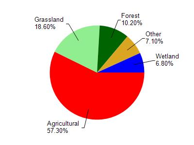
Jetzers Lake is located in the Pigeon River watershed which is 78.87 mi². Land use in the watershed is primarily agricultural (57.30%), grassland (18.60%) and a mix of forest (10.20%) and other uses (13.90%). This watershed has 110.34 stream miles, 769.54 lake acres and 3,149.60 wetland acres.
Nonpoint Source Characteristics
This watershed is ranked High for runoff impacts on streams, Not Ranked for runoff impacts on lakes and High for runoff impacts on groundwater and therefore has an overall rank of High. This value can be used in ranking the watershed or individual waterbodies for grant funding under state and county programs.However, all waters are affected by diffuse pollutant sources regardless of initial water quality. Applications for specific runoff projects under state or county grant programs may be pursued. For more information, go to surface water program grants.