Manitowoc
No
No
Yes
Fish and Aquatic Life
Overview
Hartlaub Lake, a seepage lake forming the headwaters of Calvin Creek, has an area of 38.4 acres, a
maximum depth of approximately 60 feet, and a mean depth of 20 feet. The total shoreline length is 1.2 miles, of which 0.01 miles are publicly owned. There are six acres of adjoining woody wetlands. The drainage basin covers 1 square mile. Northern pike are present, while largemouth bass and panfish are common.
Monitoring data show high phosphorus concentrations, which add to its eutrophic, or nutrient-rich,
condition. An extensive fish kill occurred in the spring of 1995. Dozens of largemouth bass and hundreds of bluegills were observed dead in the lake. The cause of this spill could not be determined with certainty although nutrient levels, especially phosphorus were very high. Land use around the lake includes undeveloped land as well as tile lines that drain agricultural fields and empty into the lake. Additional monitoring would identify pollution sources and aid the lake management process.
The Hartlaub Lake Association, along with the Manitowoc County Soil and Water Conservation
Department and WDNR staff are documenting extensive water quality problems associated with runoff from agricultural practices and their impacts on the lake. When all controllable phosphorus sources are addressed, the option of a lake rehabilitation plan may be feasible. The Hartlaub Lake Association would like to apply for a Lake Planning Grant to fund the rehabilitation plan process (Rasman 1996).
Date 2002
Author Aquatic Biologist
Overview
Hartlaub Lake Manitowoc County T18N, R23E, Sec. 10
Hartlaub Lake, a seepage lake forming the headwaters of Calvin Creek, has an area of 38.4 acres, a maximum depth of approximately 60 feet, and a mean depth of 20 feet. The total shoreline length is 1.2 miles, of which 0.01 miles are publicly owned. There are six acres of adjoining woody wetlands. The drainage basin covers 1 square mile. Northern pike are present, while largemouth bass and panfish are common.
Monitoring data show high phosphorus concentrations, which add to its eutrophic, or nutrient-rich, condition. An extensive fish kill occurred in the spring of 1995. Dozens of largemouth bass and hundreds of bluegills were observed dead in the lake. The cause of this spill could not be determined with certainty although nutrient levels, especially phosphorus were very high. Land use around the lake includes undeveloped land as well as tile lines that drain agricultural fields and empty into the lake. Additional monitoring would identify pollution sources and aid the lake management process.
The Hartlaub Lake Association, along with the Manitowoc County Soil and Water Conservation Department and WDNR staff are documenting extensive water quality problems associated with runoff from agricultural practices and their impacts on the lake. When all controllable phosphorus sources are addressed, the option of a lake rehabilitation plan may be feasible. The Hartlaub Lake Association would like to apply for a Lake Planning Grant to fund the rehabilitation plan process (Rasman 1996).
Date 1997
Author Aquatic Biologist
Historical Description
Source: 1968, Surface Water Resources of Manitowoc County Hartlaub Lake, T18N, R23E, Section 10 (7,8) Surface Acres - 38.4, S.D.F. = 1.38, Maximum depth = 59 feet.
A seepage lake with hard water in terminal moraine about 4 miles southwest of Manitowoc. The bottom is mostly mucky. Calvin Creek drains the lake through its outlet at the east end. Largemouth bass, panfish, walleye, and northern pike constitute the fishery. Use problems in the past have included algae and stunted panfish. About 6 acres of woody wetland adjoins the lake. There are 4 cottages and a boat livery. Moderate numbers of waterfowl utilize the area in the fall and both mallards and blue-wing teal may nest here. Hunting is permitted. A public access is available, and a town road provides additional access with parking.
Date 1968
Author Surface Water Inventory Of Wisconsin
Impaired Waters
Hartlaub Lake (WBIC 67200) was placed on the impaired waters list for total phosphorus on 2016. The 2018 assessments showed continued impairment by phosphorus; new total phosphorus sample data exceeded 2018 WisCALM listing thresholds for the Recreation use and Fish and Aquatic Life use. Chlorophyll-a sample data clearly met REC and FAL thresholds. Based on the most updated information, no change in existing impaired waters listing was needed.
Date 2017
Author Ashley Beranek
Impaired Waters
Hartlaub Lake (67200) was assessed during the 2016 listing cycle; total phosphorus sample data exceed 2016 WisCALM listing thresholds for the Recreation use, however, chlorophyll data do not exceed REC thresholds. Total phosphorus and chlorophyll data do not exceed Fish and Aquatic Life thresholds.
Date 2015
Author Aaron Larson
Condition
Wisconsin has over 84,000 miles of streams, 15,000 lakes and milllions of acres of wetlands. Assessing the condition of this vast amount of water is challenging. The state's water monitoring program uses a media-based, cross-program approach to analyze water condition. An updated monitoring strategy (2015-2020) is now available. Compliance with Clean Water Act fishable, swimmable standards are located in the Executive Summary of Water Condition in 2018. See also the 'monitoring and projects' tab.
Reports
Management Goals
Wisconsin's Water Quality Standards provide qualitative and quantitative goals for waters that are protective of Fishable, Swimmable conditions [Learn more]. Waters that do not meet water quality standards are considered impaired and restoration actions are planned and carried out until the water is once again fishable and swimmable
Management goals can include creation or implementation of a Total Maximum Daily Load analysis, a Nine Key Element Plan, or other restoration work, education and outreach and more. If specific recommendations exist for this water, they will be displayed below online.
Monitoring
Monitoring the condition of a river, stream, or lake includes gathering physical, chemical, biological, and habitat data. Comprehensive studies often gather all these parameters in great detail, while lighter assessment events will involve sampling physical, chemical and biological data such as macroinvertebrates. Aquatic macroinvertebrates and fish communities integrate watershed or catchment condition, providing great insight into overall ecosystem health. Chemical and habitat parameters tell researchers more about human induced problems including contaminated runoff, point source dischargers, or habitat issues that foster or limit the potential of aquatic communities to thrive in a given area. Wisconsin's Water Monitoring Strategy was recenty updated.
Grants and Management Projects
Monitoring Projects
| WBIC | Official Waterbody Name | Station ID | Station Name | Earliest Fieldwork Date | Latest Fieldwork Date | View Station | View Data |
|---|
| 66900 | Calvin Creek | 10021084 | Hartlaub Lake -- Spring Draining To Sw Corner | 3/14/1996 | 3/14/1996 | Map | Data |
| 67200 | Hartlaub Lake | 10021084 | Hartlaub Lake -- Spring Draining To Sw Corner | 3/14/1996 | 3/14/1996 | Map | Data |
| 67200 | Hartlaub Lake | 10041549 | Hartlaub Lake - N side E of public access | 7/2/2013 | 7/2/2013 | Map | Data |
| 67200 | Hartlaub Lake | 10019451 | Hartlaub Lake -- Access at NW Side Of Lake W | 2/25/1997 | 8/19/2023 | Map | Data |
| 67200 | Hartlaub Lake | 363229 | Hartlaub Lake - Deep Hole | 11/6/1980 | 4/7/2024 | Map | Data |
| 67200 | Hartlaub Lake | 10021085 | Hartlaub Lake -- Draining To West Lobe | 3/14/1996 | 7/10/1996 | Map | Data |
| 67200 | Hartlaub Lake | 10003545 | Hartlaub Lake | 4/17/1982 | 8/30/2017 | Map | Data |
| 67200 | Hartlaub Lake | 10020550 | Hartlaub Lake -- Spring Draining To North Shore | 3/14/1996 | 3/14/1996 | Map | Data |
|
Watershed Characteristics
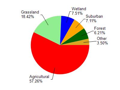
Hartlaub Lake is located in the Sevenmile and Silver Creeks watershed which is 112.90 mi². Land use in the watershed is primarily agricultural (57.20%), grassland (18.40%) and a mix of wetland (7.50%) and other uses (16.80%). This watershed has 184.08 stream miles, 10,577.89 lake acres and 4,732.70 wetland acres.
Nonpoint Source Characteristics
This watershed is ranked High for runoff impacts on streams, Not Ranked for runoff impacts on lakes and High for runoff impacts on groundwater and therefore has an overall rank of High. This value can be used in ranking the watershed or individual waterbodies for grant funding under state and county programs.However, all waters are affected by diffuse pollutant sources regardless of initial water quality. Applications for specific runoff projects under state or county grant programs may be pursued. For more information, go to surface water program grants.