Manitowoc
No
No
No
Fish and Aquatic Life
Overview
Mud Creek originates in a marsh area in the southeast corner of the town of Holland in southern Brown
County and flows southward for 15 miles through Manitowoc County before joining the main stem of the
Manitowoc River. Mud Creek has a rather low gradient and sluggish flow with a Q7, 10 of 0.12 cfs one
mile south of Reedsville. (The Q7, 10 is the seven-day mean flow below which the flow will fall an average
of once in 10 years.) Above Reedsville the Q7, 10 is .04 cfs. The stream flows through Reedsville and
drains Maple Grove Swamp on the north and Collins Marsh on the south. The stream, especially where
impounded, has a high supportive value for wildlife, with more than 2,000 acres of adjoining wetlands.
The overall water quality, based on the Hilsenhoff Biotic Index, was fair and poor (1990) at the two
stations monitored. The stream habitat evaluation at these same sites were fair (1990). Additional
monitoring will be conducted on the Manitowoc River as part of the basin long-term water quality trend
assessment. Refer to the recommendations report for more information.
The current stream classification for Mud Creek is Limited Aquatic Life (LAL). The district water quality
biologist suggests that the classification for Mud Creek be changed to a warm water forage fishery
(WWFF) in the next revision of NR 104. This proposed change may require more strict effluent limits for
the village of Reedsville WPDES permit. The village of Reedsville is presently upgrading their WWTP
to provide a higher level of treatment. An oxidation ditch with ultraviolet disinfection is being
constructed, capable of providing treatment to 10mg/l BOD5.
From: Willman, Guy and Mike Toneys. 2001. The State of the Lakeshore Basin. Wisconsin Department of Natural Resources, Madison, WI.
Date 2001
Author Michael Toneys
Overview
Collins Marsh is a state owned Wildlife Area of approximately 4,100 acres, of which 725 acres of type 4 and 5 (deep fresh marshes-soil covered with 15 cm to 1 m of water, and open fresh water-waterless than 2 m deep) wetland makeup the main marsh. This marsh was created in the early 1960s by the damming of Mud Creek. Additionally, 147 acres of type 4 wetland has been created in the past decade that drain into the main marsh when drawn down or overflowing. Other restored or created type 3 (shallow fresh marshes-soil waterlogged during growing season; often covered with 15 cm or more of water) and type 4 wetland habitat that does not drain into the main marsh comprises 27 acres (Pritzl 1996).
The area is managed for the enhancement of local and migratory wildlife populations, to provide public hunting and trapping, and to offer compatible wildlife based recreational opportunities (WDNR 1986). Collins Marsh is used extensively by waterfowl and waterfowl hunters. Other hunting includes deer, pheasant, rabbit, fox, coyote, raccoon, and mink and muskrat trapping. Canoes are available for rent at the nature center and this activity has increased recently (Pritzl 1996). Many schools use the property for field trips.
Wetland, grassland, wet and medic forest, shrub-carr, and agricultural habitats surrounding the marsh support a wide variety of wildlife. Most of the open water marsh is waterfowl refuge. In addition to being an important stopover for several thousand Canada geese and other waterfowl during spring migrations, it is also a major nesting, brooding and fall waterfowl staging area. The two most common nesting species are mallards and wood ducks. Other species that commonly use the area either for nesting or during migration are blue-winged teal, redheads, black ducks, american coots, widgeons, shovelers, gadwalls, wood ducks, pintails, lesser scaup and ring-necked ducks. Snow and blue geese are common fall migrants. Red shouldered hawks have been seen during the breeding season. Other birds that inhabit the area include red-winged blackbird, song sparrow, marsh wren, sedge wren, ring necked pheasants and swallows. Species unique in the area include osprey, least bittern, and yellow headed blackbirds. Mammals that inhabit the area include muskrat, raccoon, meadow vole and woodchuck.
The wildlife area contains one of the few known great blue heron rookeries in the state. Approximately 200 nests exist in the rookery and, on the average, about 400 young are produced each year. Two threatened and two endangered species also use Collins Wildlife Area. Two pair of Osprey, a Wisconsin threatened species, have successfully nested on Collins since 1979. Bald eagles occasionally use the marsh. Caspian and Forster's terns, Wisconsin endangered species, have been occasionally observed on the area. Great egret, threatened species, and cormorants are commonly seen in the area.
Date 1997
Author Aquatic Biologist
Impaired Waters
Mud Creek was recently evaluated during the ten-year period of 2009 through 2018 for results that were reported to the USEPA for the 2020 Clean Water Act condition report. The waterbody is considered impaired, or in poor condition for designated uses which include the quality of fish and aquatic life, recreational use, and public health and welfare (fish consumption and related). Pollutants or problems encountered during sampling (impairments) are determined based on water quality standards outlined in Wisconsin 2020 Consolidated Assessment and Listing Methodology (WisCALM). Assessment results show water conditions that are potentially harmful for Aquatic Life use due to values for total phosphorus that fall into the range expected for an aquatic community in poor health, therefore this water is listed as impaired.
Assessment results during the 2020 listing cycle show new impairment by overwhelmingly high total phosphorus levels based on 2020 WisCALM standards. Temperature was also assessed and found to be appropriate for water quality. Based on the most updated information, this water was proposed for the impaired waters list in 2020.
Date 2019
Author Ashley Beranek
Condition
Wisconsin has over 84,000 miles of streams, 15,000 lakes and milllions of acres of wetlands. Assessing the condition of this vast amount of water is challenging. The state's water monitoring program uses a media-based, cross-program approach to analyze water condition. An updated monitoring strategy (2015-2020) is now available. Compliance with Clean Water Act fishable, swimmable standards are located in the Executive Summary of Water Condition in 2018. See also the 'monitoring and projects' tab.
Reports
Management Goals
Wisconsin's Water Quality Standards provide qualitative and quantitative goals for waters that are protective of Fishable, Swimmable conditions [Learn more]. Waters that do not meet water quality standards are considered impaired and restoration actions are planned and carried out until the water is once again fishable and swimmable
Management goals can include creation or implementation of a Total Maximum Daily Load analysis, a Nine Key Element Plan, or other restoration work, education and outreach and more. If specific recommendations exist for this water, they will be displayed below online.
Monitoring
Monitoring the condition of a river, stream, or lake includes gathering physical, chemical, biological, and habitat data. Comprehensive studies often gather all these parameters in great detail, while lighter assessment events will involve sampling physical, chemical and biological data such as macroinvertebrates. Aquatic macroinvertebrates and fish communities integrate watershed or catchment condition, providing great insight into overall ecosystem health. Chemical and habitat parameters tell researchers more about human induced problems including contaminated runoff, point source dischargers, or habitat issues that foster or limit the potential of aquatic communities to thrive in a given area. Wisconsin's Water Monitoring Strategy was recenty updated.
Grants and Management Projects
| Project Name (Click for Details) | Year Started |
|---|
|
|
Monitoring Projects
| WBIC | Official Waterbody Name | Station ID | Station Name | Earliest Fieldwork Date | Latest Fieldwork Date | View Station | View Data |
|---|
| 75000 | Mud Creek | 10022755 | Mud Creek At W. Goodwin Road | | | Map | Data |
| 75000 | Mud Creek | 363086 | Mud Creek at Collins Wildlife Dam | 8/16/1979 | 5/31/2007 | Map | Data |
| 75000 | Mud Creek | 10022842 | Collins Marsh (Mud Creek) | | | Map | Data |
| 75000 | Mud Creek | 104437 | Mud Creek | | | Map | Data |
| 75000 | Mud Creek | 363211 | Mud Creek at Hilltop Rd | 8/16/1979 | 4/24/1991 | Map | Data |
| 75000 | Mud Creek | 10016717 | Mud Creek - Hilltop Road | 5/22/1979 | 11/18/2019 | Map | Data |
|
Watershed Characteristics
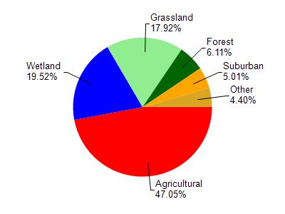
Mud Creek is located in the Lower Manitowoc River watershed which is 168.33 mi². Land use in the watershed is primarily agricultural (47%), wetland (19.50%) and a mix of grassland (17.90%) and other uses (15.50%). This watershed has 264.70 stream miles, 2,910.36 lake acres and 19,995.06 wetland acres.
Nonpoint Source Characteristics
This watershed is ranked High for runoff impacts on streams, Not Ranked for runoff impacts on lakes and High for runoff impacts on groundwater and therefore has an overall rank of High. This value can be used in ranking the watershed or individual waterbodies for grant funding under state and county programs.However, all waters are affected by diffuse pollutant sources regardless of initial water quality. Applications for specific runoff projects under state or county grant programs may be pursued. For more information, go to surface water program grants.