Project Title
Mineral Point and Sudan Branches TWA WQM Plan 2017 (SP09), Monitored in 2015
Primary Author: Jim Amrhein, Southern District Water Quality Biologist
Mineral Point Targeted Watershed Assessment: A Water Quality Plan to Restore Wisconsin Waters, 2017
Study Purpose & Setting
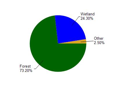
The Mineral Point and Sudan Branches Watershed lies in southwestern Iowa County and dips into extreme northern Lafayette County (Figure 1). The majority of the 70,300 acre (110 mi2) watershed is in agriculture (row crops or pastureland), with scattered woodlands and grasslands making up a majority of the balance (See graphic below). As the name of the watershed implies, Mineral Point Branch and Sudan Branch are the two main streams that drain this area. Mineral Point Branch has its headwaters along the Military Ridge just west of Dodgeville and flows 29 miles southward into Lafayette County where it joins the Pecatonica River a couple of miles northwest of Calamine. The Sudan Branch likewise has its headwaters along the Military Ridge just east of Cobb, near the village of Linden. The Sudan Branch flows 18 miles southeast and joins the Mineral Point Branch about 3 miles southwest of the village of Mineral Point (WDNR, 2003).
Population, Land Use
The population of this watershed is not expected to grow significantly (less than 2%) over the next 20 years. Land use in the watershed is primarily agricultural, with a mixture of forest , suburban and other uses making up the balance. There are two municipalities in the watershed, Linden and Mineral Point
In addition to the discharges from these two municipalities, Bloomfield Manor, an assisted living facility, also discharges to surface water in the watershed. There are also localized water quality issues caused by historic mining activity
Runoff from waste piles that remain from lead, copper and zinc mining have caused aquatic toxicity issues on Brewery Creek near Mineral Point and on Pedler Creek near Linden.
Management Priorities
Streams of the Mineral Point and Sudan Branches watershed are in good condition from a fisheries standpoint. The main stems of Sudan Branch and especially Mineral Point Branch contain a variety of species and can provide a reasonable angling opportunity.
There are impacts from nonpoint source pollution as evidenced by macroinvertebrate IBIs and the habitat scores. These impacts are most notable in the bank erosion which has exacerbated the widening of streams and led to a depressed width-to-depth ratio score and rating.
Managed grazing (appropriate numbers of livestock for the acreage), rotational grazing, and stream crossings should be employed in the riparian corridors to help maintain sod cover and help mitigate bank erosion and trampling. This would help reduce the rate of stream widening. In areas that are row cropped, buffers, cover crops, no-till farming and implementation of nutrient management plans would help reduce bank erosion and runoff of sediment and nutrients to the systems.
Resources
Watershed Overview
The Mineral Point and Sudan Branches Watershed lies in southwestern Iowa County and dips into extreme northern Lafayette County . The majority of the 70,300 acre (110 mi2) watershed is in agriculture (row crops or pastureland), with scattered woodlands and grasslands making up a majority of the balance. As the name of the watershed implies, Mineral Point Branch and Sudan Branch are the two main streams that drain this area. Mineral Point Branch has its headwaters along the Military Ridge just west of Dodgeville and flows 29 miles southward into Lafayette County where it joins the Pecatonica River a couple of miles northwest of Calamine. The Sudan Branch likewise has its headwaters along the Military Ridge just east of Cobb, near the village of Linden. The Sudan Branch flows 18 miles southeast and joins the Mineral Point Branch about 3 miles southwest of the village of Mineral Point (WDNR, 2003).
Ecological Landcapes
This watersheds ecological landscapes are depticted in Figure 3. The Southwest Savanna Ecological Landscape is located in the far southwestern part of the state. It is characterized by deeply dissected topography, unglaciated for the last 2.4 million years, with broad open hilltops and river valleys, and steep wooded slopes. The climate is favorable for agriculture but the steep slopes limit it to the hilltops and valley bottoms. Soils are underlain with calcareous bedrock. Soils on hilltops are silty loams, sometimes of shallow depth over exposed bedrock and stony red clay subsoil.Some valley soils are alluvial sands, loams, and peats. Some hilltops are almost treeless due to the thin soil while others have a deep silt loam cap. Historic vegetation consisted of tall prairie grasses and forbs with oak savannas and some wooded slopes of oak. Almost three-quarters of the current vegetation is agricultural crops with lesser amounts of grasslands, barrens, and urban areas. The major forest types are oak-hickory and maple-basswood. High-quality prairie remnants occur on rocky hilltops and slopes that are not farmed. Some prairie pastures and oak savannas still exist. The grassland areas harbor many rare grassland birds, invertebrates, and other grassland species. Relict stands of pine occur on bedrock outcroppings along some stream systems.
Hydrology
Rivers and streams in this watershed cover over 170 miles and range from small intermittent tributaries to larger rivers. The upper 3 miles of Sudan Branch, upstream of CTH X is considered Class II trout water, as is the entire length of Rock Branch. Portions of Sudan Branch, Pedler Creek and Mineral Point Branch are considered managed smallmouth bass waters. Mineral Point Branch is on the states 303(d) list of impaired waters because it exceeds the states phosphorus criteria and Brewery Creek is on the impaired waters list due to aquatic toxicity caused by heavy metals which exceed the acute criteria.
Ludden Lake is a 50-acre impoundment that was created in 1963 by constructing a dam on the Mineral Point Branch by the Mineral Hills Development Company. This company eventually dissolved and ownership of the lake and dam was taken up by the Ludden Lake District and Dam Commission which were formed in 1993. A new boat ramp and parking area completed in 1997 has improved access to the lake. That same year, northern pike were stocked into the lake. Smallmouth bass, largemouth bass, walleye, black crappie, bluegill, and carp have been found in the lake. Little is known about the water quality although algal blooms are significant in the warm months, likely due to nutrient enrichment from the surrounding agricultural landscape. Emergent aquatic vegetation from the upper end of the lake was eradicated, thus releasing a large sediment and nutrient load into the lake. Property owners around the lake have formed a lake district as a step towards addressing water quality and lake issues.
Natural Communities
Most of the streams in this HUC 10 are modelled to be cool-cold transitional headwaters or mainstem waters (Lyons, 2008). DNR has developed a method to determine whether or not the modeled natural community is accurate based on the fishery assemblage and climate conditions (Lyons, 2013). Actual water temperature, the modelled natural community, and the verified natural community did not match up that well. Temperature data collected by thermistors deployed throughout the watershed showed that actual water temperatures accurately reflected the modelled natural community at about 30% of the sites. The model overestimated water temperatures at about that same percentage of the sites particularly in the smaller, groundwater fed headwater streams - and underestimated the temperatures in another 40% of sites, particularly on the mainstems of Mineral Point Branch and the lower portions of Laxey Creek and Sudan Branch.
Site Selection & Study Design
The purpose of this study was to monitor the contemporary status of a subwatershed (HUC 12) in the Mineral Point Branch watershed. DNR collected fish, habitat, macroinvertebrate and water chemistry data for streams in this watershed. The data help determine whether these streams are achieving their attainable use in order to update the watershed tables, list waters that are not meeting their attainable use, and assess the overall health of the watersheds as required by Section 305(b) of the Clean Water Act. The data, used in conjunction with observations about watershed health, are also used to guide planning for improvements where needed. This subwatershed and the adjoining subwatersheds that make up the HUC 10 were identified as one of the top group watersheds for nutrient input by the WI Nutrient Reduction Strategy. The follow are outcomes of this study:
-Watershed was monitored with a baseline survey.
-Watershed was monitoring to understand its status and any presence of and sources of impairments.
-Streams in the system were monitored to assess condition.
-Waters are subject of watershed planning.
Methods & Procedures
 All fish were collected, identified, and counted. All gamefish were measured for length. At each site, qualitative notes on average stream width and depth, riparian buffers and land use, evidence of sedimentation, fish cover and potential management options were also recorded. A qualitative habitat survey (Simonson, et. al., 1994) was also performed at each site. Macroinvertebrate samples were obtained by kick sampling and collecting using a D-frame net at these same sites in the watershed in fall, 2015 and sent to the University of Wisconsin-Stevens Point for analysis.
Additionally, water samples were collected once per month throughout the growing season (May through October) at two sites on Mineral Point Branch. upstream and downstream of the confluence of Sudan Branch. These samples were analyzed for total phosphorus. Diatom samples were also collected at these same sites to be analyzed for calculation of a diatom nutrient index (DNI).
Bioassays were run on water samples collected from three sites on Brewery Creek to look at toxicity to aquatic organisms from heavy metals caused by leaching of mine waste. Continuous water temperature loggers were also placed at sites on Brewery Creek, Laxey Creek, Mineral Point Branch, Pedler Creek, Rock Branch, Sudan Branch and several unnamed streams and programmed to take hourly water temperatures throughout the summer (June, August) period.
Monitoring Conducted & Recommended
Monitoring Station Report
Study Results
This 2015 watershed survey was conducted by water resources biologists on 37 sites in the watershed to assess baseline conditions and evaluate bast management practices.Sites were selected to cover named streams and selected unnamed tributaries in the HUC 10. The study showed that streams of the Mineral Point and Sudan Branches watershed are in good condition from a fisheries standpoint. The mainstem portions of Sudan Branch and especially Mineral Point Branch contain a variety of species and can provide a reasonable angling opportunity. There are impacts from nonpoint source pollution as evidenced by macroinvertebrate IBIs and the habitat scores. These impacts are most notable in the bank erosion which has exacerbated the widening of streams and led to a depressed width-to-depth ratio score and rating.
Managed grazing (appropriate numbers of livestock for the acreage), rotational grazing, and stream crossings should be employed in the riparian corridors to help maintain sod cover and help mitigate bank erosion and trampling. This would help reduce the rate of stream widening. In areas that are row cropped, buffers, cover crops, no-till farming and implementation of nutrient management plans would help reduce bank erosion and runoff of sediment and nutrients to the systems.
Stream Natural Communities
Because the natural communities model (Lyons, 2008) predicted most of the waters in the watershed to be cool transitional waters, the coolwater index of biotic integrity (IBI) developed by Lyons (2012) was applied to all streams. Where appropriate and based on natural community verification (Lyons, 2013), additional IBIs were applied. A total of 47 species were found in the watershed. White sucker, creek chub, brook stickleback, and johnny darters were quite prevalent throughout the watershed, with central stoneroller, common shiner, hornyhead chub, fantail darter, and southern redbelly dace also being widely distributed. Most species found were either coolwater transitional or warmwater species (Lyons, 2012). A total of 8 intolerant species were found as well as 3 stenothermal coldwater species.
Fish Condition
Stream biologic health as indicated by the fishery IBI varies by site, but generally shows good to excellent quality. As indicated earlier, most fisheries show the natural community to be cool-warm transitional. The IBIs for these systems range from 60-100. According to WisCALM (WDNR, 2013), streams that are considered headwaters (90th percentile exceedance flow < 3 cubic feet per second) should be evaluated using the Small and Intermittent Stream IBI (Lyons, 2006). When this is applied to the streams where the verified community is confirmed as a headwater, most sites are between 60 (fair) and 100 (excellent). The exceptions to this were Brewery Creek at Copper Street, and two unnamed tributaries, WBIC =930900 and WBIC = 928500 where the small and intermittent stream IBI was poor.
Biologists ascertained that the depauperate fish community in Brewery Creek at Copper Street and the unnamed tributary (WBIC = 930900) was mainly attributed to the stream being small, with limited flow. The reason for a lack of fish in the unnamed tributary (WBIC = 928500) to Rock Branch was more unclear. According to biologists, the habitat was good and flow was adequate to support more fish. However, the (instantaneous) temperature was cold (12oC), which may have limited species diversity to some extent. Biologists noted many perched culverts on the tributaries to Mineral Point Branch along Survey Road and on an unnamed tributary (WBIC = 929400) along CTH E. However, the fishery assemblage of these tributaries, even upstream of the culverts, appears to resemble that of small, headwater streams and contain species of limited motility such as darters. Therefore the impact of these culverts appears minimal for these particular streams. On the other end of the spectrum, the natural community verification process showed the fisheries community of Mineral Point Branch to resemble a warm mainstem or warm river downstream of the Ludden Lake dam. The warmwater IBI, when applied to these sections of Mineral Point Branch show an excellent assemblage of fish.
Habitat
Qualitative habitat surveys showed overall habitat to be fair to good at all sites. Riparian buffer scores varied widely, with 40% of sites having no buffer, primarily due to pasturing in the corridor. Bank erosion also varied widely with about half the sites having a poor or fair bank erosion score, and the other half having good to excellent. Streams with significant pool areas were scarce throughout the watershed. Of the named streams in the watershed, Brewery Creek and Mineral Point Branch had the lowest width-to-depth ratios with a majority of their sites being fair. Riffle or bend scores were predominantly ?good? throughout the watershed, as were fine sediment scores. Three-quarters of the sites surveyed had good to excellent fish habitat.
Total Phosphorus
Total phosphorus data collected during the growing season in 2015 at North Oak Road and a CTH O is summarized in Table 3. The average and median phosphorus concentration was approximately 0.11 mg/l at both sites and thus was not significantly different. All concentrations except for the October sample taken at CTH O were at or above the state?s water quality criteria of 0.075 mg/l (WDNR, 2013) for total phosphorus. It was noted by biologists that the data collected at North Oak Park Road may have been influenced by cattle activity immediately upstream of the sample site on any particular sampling day.
Total phosphorus data collected during the growing season in 2015 at North Oak Road and a CTH O is summarized in Table 3. The average and median phosphorus concentration was approximately 0.11 mg/l at both sites and thus was not significantly different. All concentrations except for the October sample taken at CTH O were at or above the state?s water quality criteria of 0.075 mg/l (WDNR, 2013) for total phosphorus. It was noted by biologists that the data collected at North Oak Park Road may have been influenced by cattle activity immediately upstream of the sample site on any particular sampling day.
Temperature Data
Temperature data, collected hourly from May to October at 13 sites showed temperature varied by stream and position in the watershed. The unnamed tributaries which generally represent 1st through 3rd order streams generally had peak daily mean temperatures less than 20.7 degrees celcius, which would define them as coldwater (Lyons, et. al., 2009).
Likewise, Brewery Creek and the headwaters of Mineral Point Branch also had maximum mean temperatures below that same threshold. Mineral Point Branch at CTH QQ, downstream of Ludden Lake, had the highest water temperatures with daily mean temperatures routinely in excess of 24.6oC, or warm (Ibid). Further downstream at North Oak Park Road and at CTH O, temperatures were more moderate, but still exceeded cool-warm to warm temperatures. Other major systems such as Laxey Creek, Pedler Creek, Sudan Branch and Rock Branch have mean water temperatures that fall in the cool transitional range. The temperature data portrayed in this study is informative; however, the stream and temperature model is based on 20 years of annual temperature. While variations from the modeled results or predicted stream community may arise for one or more analyzed year within a given study, the model verification process incorporating fish community results, extreme temperature datasets, and additional site specific information provide greater weight for the final natural community validation or recommended change process.
Macroinvertebrate Data
Macroinvertebrates were collected at 28 sites in the watershed. The samples were analyzed and reported for the macroinvertebrate index of biotic integrity (MIBI) (Weigel, 2003) and the Hilsenhoff Biotic Index (HBI) (Hilsenhoff, 1987). The vast majority of MIBI scores and rankings were poor to fair with several tributaries in the good ranking. By contrast, most of the HBI scores/rankings were in the good category indicating slight to some organic loading.
Study Discussion
 Actual water temperature data collected in the watershed shows summer temperatures to vary based on stream and position in the watershed. While many streams had water temperatures that were cold or cool transitional, in most cases, the thermal composition of species (cold, warm, or transitional) indicated these streams resemble cool-warm or warm systems (Ibid). There is a fair amount of diversity of nongame species in most of the streams and coldwater species are limited to certain streams or stretches of streams. Environmental degradation can sometimes explain the discrepancy between the modelled and actual community where there is a lack of intolerant species and a dominance of tolerant ones (Ibid). For most systems in this HUC 10, the percentage of tolerant fish fall within expected ranges for cool-cold transitional systems, and therefore a degraded community is not the principle reason for the discrepancy. The discrepancy between the temperature data and the fishery community can happen for several other reasons: either the year of the thermal measurement wasn?t representative of the long-term average, the modeled thermal values were inaccurate, or both (Lyons, personal communication, 2016). In this case, air temperatures during the 2015 summer season over which the thermisters were deployed were not considered abnormal as air temperatures were within the lower 10th and upper 90th percentile. The fishery is a long-term gauge of conditions in the stream and is therefore most important for bioassessment. That?s not to say measured water temperatures aren?t useful, but for natural community determination and IBI purposes, and in the absence of moderate to severe environmental perturbation, the fishery assemblage trumps water temperature data (Ibid).
Trout were limited to certain streams and stretches of streams where stocking has been occurring. There were two notable exceptions to this where trout were found in the absence of stocking. Brook trout were found on Laxey Creek at CTH B, although brook trout have not been stocking in the creek since 1999 (Bradd Sims, personal communication). Brown trout were found in Brewery Creek even though the stream is not stocked. Conversely, Sudan Branch and Rock Branch are considered trout waters, and are currently stocked with brown trout. However, returns on trout were meager at best. Mottled sculpin, a native stenothermal coldwater indicator species were found in low numbers in Pedler Creek and Rock Branch, and in more modest numbers in the upper section of Sudan Branch. Even with the presence of this species, most of the fish in these three systems are cool transitional or warmwater species and the verified natural community is cool-warm.
Several unnamed tributaries and/or headwaters revealed the coldest temperatures of any streams in the watershed, yet did not contain any coldwater indicator species. This is not surprising considering they drain to relatively warmer systems that would not offer a source of coldwater species recruitment. For the most part, these headwaters streams are 1st through 3rd order streams and contained a subset of fish from the larger systems to which they drained. Water temperatures in these tributaries are generally in the coldwater thermal regime in that their mean temperatures remain below what is defined as cold in Lyons, et. al. (2009). This is typical for these perennial spring-fed streams. Species assemblages for these smaller systems were generally made up of brook sticklebacks, fantail and johnny darter, and occasionally creek chubs. Most of these are considered pioneer species and can tolerate a variety of conditions and cooler water temperatures. Species diversity was consistent on the major streams such as Laxey Creek, Mineral Point Branch, and Sudan Branch. As is typical with most systems as one moves downstream, headwater species tend to disappear and are replaced by species which prefer larger water and more flow. However, the majority of sites were regularly made up of white suckers, creek chubs, central stoneroller, common shiner, hornyhead chub, fantail darter, and southern redbelly dace. Larger river species such as redhorse tended to be found in the lower ? of Mineral Point Branch (downstream of Ludden Lake) and Sudan Branch (downstream of CTH E).
Of the game species, smallmouth bass were the most widely distributed, found in Laxey Creek, Mineral Point Branch, and Sudan Branch. It would appear Laxey Creek serves as a nursery stream for smallmouth, while Mineral Point and Sudan Branches hold good numbers of multi-year class fish. Catfish appear to be restricted to Mineral Point Branch downstream of Ludden Lake, but are found in good numbers, with a few stragglers making their way up to the lower reaches of Sudan Branch. In general, the size of channel catfish was notable, with fish larger than 18 inches being common. Walleye and northern pike were found in limited numbers in Mineral Point Branch.
Stream biologic health as indicated by the fishery IBI varies by site, but generally shows good to excellent quality. As indicated earlier, most fisheries show the natural community to be cool-warm transitional. The IBIs for these systems range from 60-100. According to WisCALM (WDNR, 2013), streams that are considered headwaters (90th percentile exceedance flow < 3 cubic feet per second) should be evaluated using the Small and Intermittent Stream IBI (Lyons, 2006). When this is applied to the streams where the verified community is confirmed as a headwater, most sites are between 60 (fair) and 100 (excellent). The exceptions to this were Brewery Creek at Copper Street, and two unnamed tributaries, WBIC =930900 and WBIC = 928500 where the small and intermittent stream IBI was poor. Biologists ascertained that the depauperate fish community in Brewery Creek at Copper Street and the unnamed tributary (WBIC = 930900) was mainly attributed to the stream being small, with limited flow. The reason for a lack of fish in the unnamed tributary (WBIC = 928500) to Rock Branch was more unclear. According to biologists, the habitat was good and flow was adequate to support more fish. However, the (instantaneous) temperature was cold (12oC), which may have limited species diversity to some extent. Biologists noted many perched culverts on the tributaries to Mineral Point Branch along Survey Road and on an unnamed tributary (WBIC = 929400) along CTH E. However, the fishery assemblage of these tributaries, even upstream of the culverts, appears to resemble that of small, headwater streams and contain species of limited motility such as darters. Therefore the impact of these culverts appears minimal for these particular streams.
On the other end of the spectrum, the natural community verification process showed the fisheries community of Mineral Point Branch to resemble a warm mainstem or warm river downstream of the Ludden Lake dam. The warmwater IBI, when applied to these sections of Mineral Point Branch show an excellent assemblage of fish.
Management Recommendations
Total phosphorus exceeds the state criteria of 0.075 mg/l and thus Mineral Point Branch will remain on the state?s 303(d) list of impaired waters. The aforementioned nonpoint source best management practices would also help reduce phosphorus delivery to the stream. Fisheries management has several recommendations for Mineral Point Branch: no stocking of fish, maintaining the current size regulations, develop projects which would provide more habitat for smallmouth bass, especially the creation of deep pools and runs to hold adults year round. Below Ludden Lake specifically, fisheries management recommends looking at efforts to secure stream bank easements.
Fisheries management should determine the reason for lack of trout returns in the upper Sudan Branch and in Rock Branch and to determine if it is practical to continue stocking efforts on these two streams.
Fisheries management may want to consider the lower half of Laxey Creek as a managed smallmouth bass water (nursery stream) as it may be hospitable for some production of bass.
DNR should seek opportunities to work collaboratively on projects which would benefit overall ecosystem health. Such opportunities include working with the Southwest Grasslands and Stream Conservation Area and Southwest Grasslands Bird Conservation Area. The department should work with groups to identify areas which would overlap as a priority for these programs, such as the upper Mineral Point watershed. These projects would also benefit Ludden Lake.
Ludden Lake should be added to the state?s 303(d) list of impaired waters because levels of total phosphorus and chlorophyll a exceed criteria and thresholds for shallow lowland lakes. The department should seek the aforementioned opportunities to work with partners to decrease soil and nutrient loss in the watershed upstream of Ludden Lake in order to improve water clarity, enhance macrophyte growth, and maintain the depth of the lake system which has been decreased over time due to sediment loads from upstream.
The classification of Brewery Creek should be updated to reflect the biota using a contemporary classification system.
The classification of Furnace Branch should be updated to reflect the current biota using a contemporary classification system.
The department should revise the classification of Laxey Creek to remove the variance section at the headwater.
There are a number of perched culverts on the tributaries that feed the upper Mineral Point Branch along Survey Road. The department should look for opportunities to work with the county and townships to properly replace these culverts.
Partner Recommendations
1) DNR should seek opportunities to work collaboratively on projects which would benefit overall ecosystem health. Such opportunities include working with the Southwest Grasslands and Stream Conservation Area and Southwest Grasslands Bird Conservation Area.
2) The department should work with groups to identify areas which would overlap as a priority for these programs, such as the upper Mineral Point watershed. These projects would also benefit Ludden Lake.
3) There are a number of perched culverts on the tributaries that feed the upper Mineral Point Branch along Survey Road. The department should look for opportunities to work with the county and townships to properly replace these culverts.
Monitoring and Planning
This Water Quality Management Plan was created under the states Water Quality Management Planning and Water Resources Monitoring Programs. The plan reflects Water Quality Bureau and Water Resources Monitoring Strategy 2015-2020 goals and priorities and fulfills Areawide Water Quality Management Planning milestones under the Clean Water Act, Section 208. Condition information and resource management recommendations support and guide program priorities for the plan area.
Related Studies, Plans
This plan is hereby approved by the Wisconsin DNR Water Quality Program and is a formal update to the Sugar Pecatonica Areawide Water Quality Management Plan and Wisconsins Statewide Areawide Water Quality Management Plan. This plan will be forwarded to USEPA for certification as a formal plan update.
Contributors
Jim Amrhein, Primary Investigator, Author and Water Quality Biologist
Victoria Ziegler, Program Support
Lisa Helmuth, Program Coordinator
Greg Searle, Field Operations Manager
Tim Asplund, Monitoring Section Chief
Partners
Iowa County Land Conservation Department
Lafayette County Land Conservation/Planning/Zoning
Wisconsin Dept. of Natural Resources
Driftless Area Land Conservancy
The Prairie Enthusiasts
The Nature Conservancy
Southwest Wisconsin Resource Conservation and Development Council
Water Details
Click for list of waters in SP09
Temperature Graphs
Temperature Graphs [PDF File]
References
Hilsenhoff, William L. 1987. An Improved Biotic Index of Organic Stream Pollution. The Great Lakes Entomologist. 20: 31-39.
Lyons, John. 1992. Using the Index of Biotic Integrity (IBI) to Measure Environmental Quality in Warmwater Streams of Wisconsin. United States Department of Agriculture. General Technical Report NC-149.
Lyons, John. 2006. A Fish-based Index of Biotic Integrity to Assess Intermittent Headwater Streams in Wisconsin, USA. Environmental Monitoring and Assessment 122: 239-258.
Lyons, John. 2008. Using the Wisconsin Stream Model to Estimate the Potential Natural Community of Wisconsin Streams (DRAFT). Wisconsin Department of Natural Resources Fish and Aquatic Life Research Section. November, 2008.
Lyons, John. T. Zorn, J. Stewart, P Seelbach, K Wehrly, and L. Wang. 2009. Defining and Characterizing Coolwater Streams and Their Fish Assemblages in Michigan and Wisconsin, USA. North American Journal of Fisheries Management. 29:1130-1151.
Lyons, John. 2012. Development and Validation of Two Fish-based Indices of Biotic Integrity for Assessing Perennial Coolwater Streams In Wisconsin, USA. Ecological Indicators 23 (2012) 402-412.
Lyons, John. 2013. Methodology for Using Field Data to Identify and Correct Wisconsin Stream Natural Community Misclassifications. Version 4. May 16, 2013.IN DRAFT.
Simonson, Timothy D., J. Lyons, and P.D. Kanehl. 1994. Guidelines for Evaluating Fish Habitat in Wisconsin Streams. U.S. Department of Agriculture. Forest Service. General Technical Report NC-164.
Sims, Bradd. 2013. Ludden Lake, Iowa County. 2013 Comprehensive Fisheries Survey. Wisconsin Department of Natural Resources. December, 2013.
WDNR. 2003. The State of the Sugar and Pecatonica River Basins. Wisconsin Department of Natural Resources.
WDNR. 2013. Wisconsin 2014 Consolidated Assessment and Listing Methodology (WisCALM). Clean Water Act Section 305(b), 314, and 303(d) Integrated Reporting. Wisconsin Department of Natural Resources. Bureau of Water Quality Program Guidance. September, 2013.
Weigel, Brian. 2003. Development of Stream Macroinvertebrate Models That Predict Watershed and Local Stressors in Wisconsin. Journal of the North American Benthological Society. 22(1): 123-142.
Basins, Watersheds & More
Links to Related Sites
Watershed - Mineral Point and Sudan Branches (SP09)
Click for list of waters in SP09
Watershed Trout Streams
Watershed Outstanding & Exceptional Resources
Impaired Waters in Mineral Point and Sudan Branches
Projects in the Mineral Point and Sudan Branches
Abbreviations
BMP Best Management Practice.
A practice that is effective and practicable (including technological, economic, and institutional considerations) in preventing or reducing pollution generated from nonpoint sources to a level compatible with water quality goals.
DNR Department of Natural Resources.
Wisconsin Department of Natural Resources is an agency of the State of Wisconsin created to preserve, protect, manage, and maintain natural resources.
FIBI Fish Index of biological integrity (Fish IBI).
An Index of Biological Integrity (IBI) is a scientific tool used to identify and classify water pollution problems. An IBI associates anthropogenic influences on a water body with biological activity in the water and is formulated using data developed from biosurveys. In Wisconsin, Fish IBIs are created for each type of natural community in the states stream system.
HUC Hydrologic Unit Code.
A code or sequence of numbers that identify one of a number of nested and interlocked hydrologic catchments delineated by a consortium of agencies including USGS, USFS, and Wisconsin DNR.
MIBI Macroinvertebrate Index of biological integrity.
In Wisconsin, the mIBI, or macroinvertebrate Index of biological integrity, was developed specifically to assess Wisconsins macroinvertebrate community (see also Fish IBI).
Natural Community.
A system of categorizing waterbodies based on their inherent physical, hydrologic, and biological assemblages. Both Streams and Lakes are categorized using an array of natural community types.
Monitoring Seq. No.
Monitoring Sequence Number refers to a unique identification code generated by the Surface Water Integrated Monitoring System (SWIMS), which holds much of the states water quality monitoring data.
SWIMS ID
Surface Water Integrated Monitoring System (SWIMS) Identification Code is the unique monitoring station identification number for the location where monitoring data was gathered.
TWA Targeted Watershed Assessment.
A statewide study design a rotating watershed approach to gathering of baseline monitoring data with specialized targeted assessments for unique and site specific concerns, such as effectiveness monitoring of management actions.
WATERS ID
The Waterbody Assessment,Tracking and Electronic Reporting System Identification Code (WATERS ID) is a unique numerical sequence number assigned by the WATERS system, also known as Assessment Unit ID code.
WBIC Water Body Identification Code.
WDNR unique identification codes assigned to water features in the state. The lines and information allow the user to execute spatial and tabular queries about the data, make maps, and perform flow analysis and network traces.