Waupaca
No
No
No
Fish and Aquatic Life
Overview
Weyauwega Lake is a very fertile, hard water impoundment of the Waupaca River containing light brown water. Sand and muck are the predominant littoral bottom types. The fishery is dominated by rough fish including carp, redhorse, white sucker, and bowfin. Game species present are bluegill, black crappie, perch, largemouth bass, smallmouth bass, northern pike, pumpkinseed, white bass, and rock bass. This lake is scheduled for chemical treatment in 1971 to rehabilitate the fishery. Bluewing teal nest on the lake but because of its close proximity to Weyauwega, waterfowl use is quite limited. Public facilities on the lake include a boat landing, an access without parking, and a swimming beach. A private park, Mullen Park, is open to the public. Included in this park are picnic areas, playgrounds, toilets, drinking water, shelters, and boat docks. Other access is provided by navigable water via the inlet and the outlet. The lake is presently used as a water supply for an electric generating plant. About twenty dwellings are located on the lake. Several sources of pollution enter the lake including effluent from Waupaca County Hospital, storm sewers, and effluent from Ace Manufacturing. All contribute to the enrichment of Weyauwega Lake.
Source: 1971, Surface Water Resources of Waupaca County Weyauwega Lake, T21N, R13E, Sections 4, 5 Surface Acres = 274.2; S.D.F. = 1.93; Maximum Depth = 11 feet.
Date 1971
Author Aquatic Biologist
Recommendations
Drawdown of Water
Weyauwega Lake Drawdown
County Land and Water Management Plan
Waupaca County Land and Water Conservation Department is sponsoring a project to develop a Nine Key Element Watershed Plan for the Weyauwega Lake Watershed which is an impoundment of the Waupaca River in Weyauwega, Wisconsin Project final deliverables include: The Nine Key Element Watershed Plan is the primary deliverable in hard copy and electronic form. Specific project activities include: 1.Hire staff to write the Nine Key Element Plan in January through March 2018. 2. Convene stakeholder group for information, education and goal achievement recommendations before March 31st, 2018. 3. Run EVAAL, STEPL, and ACPF models to identify the high-risk non-point source areas within the watershed (late Spring/Summer 2018). 4. Establish partner network to assist with monitoring strategy with the Weyauwega-Fremont High School and WDNR to verify results (Summer 2018). 5.Create draft of Weyauwega Lake Nine Key Element Watershed Plan by October 2018. The report will summarize current conditions, provide comparisons to earlier information, projections for future conditions and potential risks, and recommendations for protection and restoration. 6. Update and distribute the Weyauwega Lake Nine Key Element Watershed Plan to WDNR and EPA by December 31st, 2018. Three hard copies will be sent to WDNR Water Resources staff along with the link to the electronic .pdf. 7. Provide list of stewardship groups, agencies, schools and municipalities receiving the report and copies of publications of the report in local newspapers to the WDNR Water Resources staff. 8. Provide dates, agendas, and minutes from meetings with municipality boards and WLR, Inc related to the Weyauwega Lake Nine Key Element Watershed Plan to WDNR Water Resources staff. 9. Provide a description of how the report will be distributed to watershed property owners to WDNR Water Resources staff (by December 31st, 2018).
Monitor Targeted Watershed Area (TWA)
Lake Weyauwega, Waupaca Watershed TWA, Waupaca County
Best Management Practices, Implement
The monitoring in 2017 indicate water quality in the tributaries of the Lake Weyauwega sub-watershed ranges from poor to excellent. Some of the land use characteristics observed during the 2017 monitoring project that can have a negative impact to the water quality of the tributaries to the Waupaca River were limited buffer protection along the stream corridors, wetland ditching, eroding stream banks, cropland erosion, channelization, cattle access, tile drainage, presence of aquatic invasive species, and sedimentation of fish and aquatic life habitat
There are opportunities to install practices to lower the nutrients and sediment reaching the Waupaca River and Lake Weyauwega. Continuing efforts to work with landowners, farmers, municipalities, the county and Natural Resource Conservation Service staff to promote protection and restoration of the streams and wetlands by practices including, but not limited to, streambank and buffer protection, cover crops, nutrient management planning, reduced tillage, wetland protection and restoration, and water and sediment control basins
Management Goals
Wisconsin's Water Quality Standards provide qualitative and quantitative goals for waters that are protective of Fishable, Swimmable conditions [Learn more]. Waters that do not meet water quality standards are considered impaired and restoration actions are planned and carried out until the water is once again fishable and swimmable
Management goals can include creation or implementation of a Total Maximum Daily Load analysis, a Nine Key Element Plan, or other restoration work, education and outreach and more. If specific recommendations exist for this water, they will be displayed below online.
Monitoring
Monitoring the condition of a river, stream, or lake includes gathering physical, chemical, biological, and habitat data. Comprehensive studies often gather all these parameters in great detail, while lighter assessment events will involve sampling physical, chemical and biological data such as macroinvertebrates. Aquatic macroinvertebrates and fish communities integrate watershed or catchment condition, providing great insight into overall ecosystem health. Chemical and habitat parameters tell researchers more about human induced problems including contaminated runoff, point source dischargers, or habitat issues that foster or limit the potential of aquatic communities to thrive in a given area. Wisconsin's Water Monitoring Strategy was recenty updated.
Grants and Management Projects
Monitoring Projects
| WBIC | Official Waterbody Name | Station ID | Station Name | Earliest Fieldwork Date | Latest Fieldwork Date | View Station | View Data |
|---|
| 257700 | Weyauwega Lake | 694011 | Weyauwega Lake - Weyauwega Lake | 7/30/1979 | 7/30/1979 | Map | Data |
| 257400 | Waupaca River | 693011 | Waupaca River - Ace Mfg Co Weyauwega Outfall 001 | 1/15/1976 | 1/15/1976 | Map | Data |
| 257700 | Weyauwega Lake | 10019165 | Waupaca River - Weyauwega Lake -- Access | | | Map | Data |
| 257400 | Waupaca River | 10041483 | Weyauwega Lake Inlet | | | Map | Data |
| 257700 | Weyauwega Lake | 10019349 | Weyauwega Lake -- Access | 5/16/2024 | 5/16/2024 | Map | Data |
| 257700 | Weyauwega Lake | 10007312 | Weyauwega Lake | 5/4/1996 | 9/22/2017 | Map | Data |
| 257700 | Weyauwega Lake | 693179 | Weyawega Lake - Channel | 6/10/1987 | 9/27/1997 | Map | Data |
| 257400 | Waupaca River | 10019165 | Waupaca River - Weyauwega Lake -- Access | | | Map | Data |
| 257700 | Weyauwega Lake | 693085 | Weyauwega Lake - Deep Hole | 6/10/1987 | 8/8/2016 | Map | Data |
|
Watershed Characteristics
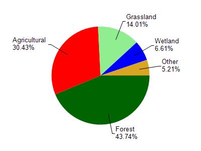
Weyauwega Lake is located in the Waupaca River watershed which is 290.77 mi². Land use in the watershed is primarily forest (43.70%), agricultural (30.40%) and a mix of grassland (14%) and other uses (11.80%). This watershed has 231.34 stream miles, 2,456.10 lake acres and 14,124.68 wetland acres.
Nonpoint Source Characteristics
This watershed is ranked Medium for runoff impacts on streams, Not Ranked for runoff impacts on lakes and High for runoff impacts on groundwater and therefore has an overall rank of High. This value can be used in ranking the watershed or individual waterbodies for grant funding under state and county programs.However, all waters are affected by diffuse pollutant sources regardless of initial water quality. Applications for specific runoff projects under state or county grant programs may be pursued. For more information, go to surface water program grants.