Kenosha
No
No
No
Fish and Aquatic Life
Overview
This is the 3rd largest lake in Kenosha County. It is primarily a warm water seepage lake but receives a large amount of drainage water in spring from 2 inlets on its north end. The most westerly inlet begins its drainage area at Krull Lake. The other drains adjacent wetlands. About 90% of the lake's watershed area is in agriculture, although most of its shoreline is developed and the Village of Silver Lake adjoins it.
Presently, the lake supports one of the best sport fisheries in this part of the state. Management is for northern pike, largemouth bass, walleye, and panfish. Walleye fingerlings are stocked on alternate years to evaluate survival and natural reproduction. Diving ducks are common during migratory flights in spring and fall. This indicates the generally high quality of the lake's waters. Most of the developments around the lake are connected to a sanitary sewerage district that eliminates septic systems pollution.
Presently, there are 1.3 miles of public frontage in a state-owned public access and a county park. The Village ofSilver Lake provides a public beach and controls some rights-of-way to the lake within the village limits. There are also 2 boat rentals.
Source: 1982, Surface Water Resources of Kenosha County
Silver Lake, TIN, R20E, Section 8, 9, 16, 17
Surface Acres = 464, Maximum Depth = 43 ft, Secchi disc = 5 ft
Date 1982
Author Aquatic Biologist
General Condition
Silver Lake (747900) was assessed during the 2016 listing cycle; total phosphorus and chlorophyll sample data were clearly below 2016 WisCALM listing thresholds for the Recreation use and Fish and Aquatic Life use. This water is meeting these designated uses and is not considered impaired.
Date 2015
Author Ashley Beranek
Condition
Wisconsin has over 84,000 miles of streams, 15,000 lakes and milllions of acres of wetlands. Assessing the condition of this vast amount of water is challenging. The state's water monitoring program uses a media-based, cross-program approach to analyze water condition. An updated monitoring strategy (2015-2020) is now available. Compliance with Clean Water Act fishable, swimmable standards are located in the Executive Summary of Water Condition in 2018. See also the 'monitoring and projects' tab.
Reports
Management Goals
Wisconsin's Water Quality Standards provide qualitative and quantitative goals for waters that are protective of Fishable, Swimmable conditions [Learn more]. Waters that do not meet water quality standards are considered impaired and restoration actions are planned and carried out until the water is once again fishable and swimmable
Management goals can include creation or implementation of a Total Maximum Daily Load analysis, a Nine Key Element Plan, or other restoration work, education and outreach and more. If specific recommendations exist for this water, they will be displayed below online.
Monitoring
Monitoring the condition of a river, stream, or lake includes gathering physical, chemical, biological, and habitat data. Comprehensive studies often gather all these parameters in great detail, while lighter assessment events will involve sampling physical, chemical and biological data such as macroinvertebrates. Aquatic macroinvertebrates and fish communities integrate watershed or catchment condition, providing great insight into overall ecosystem health. Chemical and habitat parameters tell researchers more about human induced problems including contaminated runoff, point source dischargers, or habitat issues that foster or limit the potential of aquatic communities to thrive in a given area. Wisconsin's Water Monitoring Strategy was recenty updated.
Grants and Management Projects
Monitoring Projects
| WBIC | Official Waterbody Name | Station ID | Station Name | Earliest Fieldwork Date | Latest Fieldwork Date | View Station | View Data |
|---|
| 747900 | Silver Lake | 10003101 | Silver Lake | 7/29/1976 | 8/22/2023 | Map | Data |
| 747900 | Silver Lake | 10017517 | Silver Lake -- Access at Fishery Area - N Side Lake | | | Map | Data |
| 747900 | Silver Lake | 303123 | Silver Lake - Deep Hole | 9/17/1973 | 6/29/2026 | Map | Data |
| 747900 | Silver Lake | 10060631 | Silver Lake - Beach | 6/24/2026 | 6/24/2026 | Map | Data |
| 747900 | Silver Lake | 10017999 | Silver Lake -- Access Nr County Hwy F | 5/20/2007 | 5/27/2023 | Map | Data |
| 747900 | Silver Lake | 10017518 | Silver Lake -- Access at Fishery Area - Nr 288th | 5/13/2007 | 5/31/2024 | Map | Data |
| 747900 | Silver Lake | 10017516 | Silver Lake -- Access Nr Cogswell | 6/1/2000 | 8/13/2010 | Map | Data |
| 747900 | Silver Lake | 10018000 | Silver Lake -- Access Nr Cogswell And E Lake St | 5/24/2008 | 6/24/2026 | Map | Data |
|
Watershed Characteristics
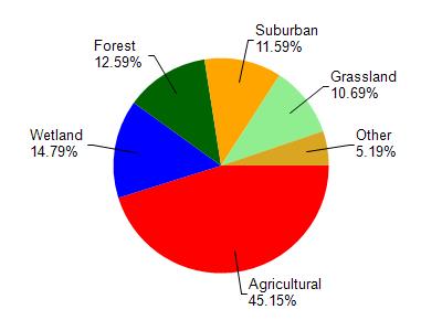
Silver Lake is located in the Lower Fox River - Illinois watershed which is 114.04 mi². Land use in the watershed is primarily agricultural (45.20%), wetland (14.80%) and a mix of forest (12.60%) and other uses (27.50%). This watershed has 144.75 stream miles, 2,176.46 lake acres and 9,772.38 wetland acres.
Nonpoint Source Characteristics
This watershed is ranked Medium for runoff impacts on streams, Medium for runoff impacts on lakes and High for runoff impacts on groundwater and therefore has an overall rank of High. This value can be used in ranking the watershed or individual waterbodies for grant funding under state and county programs.However, all waters are affected by diffuse pollutant sources regardless of initial water quality. Applications for specific runoff projects under state or county grant programs may be pursued. For more information, go to surface water program grants.