Kenosha, Walworth
No
No
No
Fish and Aquatic Life
Overview
Part of this warm water seepage lake is in Walworth County, its water level is controlled by a dam on the outlet of Lake Tombeau that maintains a 1.0 ft head. Dissolved oxygen and temperature profiles taken in mid-summer are not conclusive but indicate that trout stocking on an experimental basis may have possibilities. Most of the immediate watershed is developed into summer homes since the lake is attractive to swimmers, boaters, and water skiers as well as fishermen. Its general watershed is part of those of Powers and Tombeau lakes and is mainly in agricultural crops. Various species of waterfowl use the lake for feeding and resting, primarily during spring and fall migratory flights since there is little nesting habitat left. The high incidence of development also limits the abundance of upland game near the lake but cottontail rabbits, squirrels, foxes, and pheasants are common in the agricultural areas. Marsh furbearers such as mink, muskrats and raccoon are common. The lake is primarily managed for largemouth bass and panfish, both about average for southeast Wisconsin. Other gamefish include northern pike and some walleyes. Walleyes are reportedly caught by anglers although none were captured in recent surveys. They are believed to have moved from Powers Lake into the Tombeau- Benedict complex. Other panfish include black, brown, and yellow bullheads, warmouth, green and pumpkinseed sunfish and yellow chub sucker, banded killfish, brook silversides, spotfin shiners, and johnny darters. Public access is restricted to a roadside right-of-way. One resort on the north side of the lake charges a fee to launch and park.
Source: 1982, Surface Water Resources of Kenosha County Benedict Lake, T1N, R18-19E, Section 19, Surface area = 31.6 acres, Maximum Depth = 38 ft, Secchi disk = 7ft.
Date 1982
Author Aquatic Biologist
Condition
Wisconsin has over 84,000 miles of streams, 15,000 lakes and milllions of acres of wetlands. Assessing the condition of this vast amount of water is challenging. The state's water monitoring program uses a media-based, cross-program approach to analyze water condition. An updated monitoring strategy (2015-2020) is now available. Compliance with Clean Water Act fishable, swimmable standards are located in the Executive Summary of Water Condition in 2018. See also the 'monitoring and projects' tab.
Reports
Recommendations
Habitat Restoration - Shoreland
Walworth County will continue the Walworth County Lakes Specialist position for one year. The Lakes Specialist will provide educational information to lake residents regarding shoreline stabilization and shoreline restoration. The Lakes Specialist will also design shoreline restoration projects for interested landowners, provide technical assistance to contractors and hold workshops on shoreland restoration.
Protect Riparian or Shorelands
Walworth County will implement the Shoreland Protection Initiative project that includes: 1. A baseline lakeshore inventory; 2. ten lakshore demonstration sites; 3. the preparation of lake lawn and yard nutrient management plans; 4. fact sheets on lakeshore stabilization, shoreland buffers, shoreland regulations and lawn care; 5. an annual lakeshore inventory and distribution of shoreland regulation materials; 6. formation of a Walworth Co. Lakes Association and meetings with and newsletter pertaining to Walworth Co. lakes; 7. Workshops, information packets and news articles pertaining to the Fox river Basin Partnership Team Lakes Initiative; and 8. the formation of the Walworth County Land Conservancy.
Management Goals
Wisconsin's Water Quality Standards provide qualitative and quantitative goals for waters that are protective of Fishable, Swimmable conditions [Learn more]. Waters that do not meet water quality standards are considered impaired and restoration actions are planned and carried out until the water is once again fishable and swimmable
Management goals can include creation or implementation of a Total Maximum Daily Load analysis, a Nine Key Element Plan, or other restoration work, education and outreach and more. If specific recommendations exist for this water, they will be displayed below online.
Monitoring
Monitoring the condition of a river, stream, or lake includes gathering physical, chemical, biological, and habitat data. Comprehensive studies often gather all these parameters in great detail, while lighter assessment events will involve sampling physical, chemical and biological data such as macroinvertebrates. Aquatic macroinvertebrates and fish communities integrate watershed or catchment condition, providing great insight into overall ecosystem health. Chemical and habitat parameters tell researchers more about human induced problems including contaminated runoff, point source dischargers, or habitat issues that foster or limit the potential of aquatic communities to thrive in a given area. Wisconsin's Water Monitoring Strategy was recenty updated.
Grants and Management Projects
Monitoring Projects
| WBIC | Official Waterbody Name | Station ID | Station Name | Earliest Fieldwork Date | Latest Fieldwork Date | View Station | View Data |
|---|
| 743900 | Benedict Lake | 10017584 | Benedict Lake -- Access at N Side Of Lake Nr 93rd | 8/20/2010 | 8/26/2010 | Map | Data |
| 743900 | Benedict Lake | 303067 | Benedict Lake - Deep Hole | 7/12/1989 | 9/1/2014 | Map | Data |
| 743900 | Benedict Lake | 10003094 | Benedict Lake | 8/3/1967 | 9/15/2017 | Map | Data |
|
Watershed Characteristics
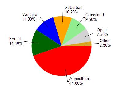
Benedict Lake is located in the White River and Nippersink Creek watershed which is 168.35 mi². Land use in the watershed is primarily agricultural (44.80%), forest (14.40%) and a mix of wetland (11.30%) and other uses (29.50%). This watershed has 239.00 stream miles, 8,603.24 lake acres and 10,838.84 wetland acres.
Nonpoint Source Characteristics
This watershed is ranked High for runoff impacts on streams, Medium for runoff impacts on lakes and High for runoff impacts on groundwater and therefore has an overall rank of High. This value can be used in ranking the watershed or individual waterbodies for grant funding under state and county programs.This water is ranked High Lake for individual Lakes based on runoff problems and the likelihood of success from project implementation.