Adams
No
No
No
Fish and Aquatic Life
Overview
The Upper Fox River Basin Plan identifies the potential use of Peppermill Creek as COLD and existing use as WWFF. A fish survey in 2007 captured salmonid species, with other salmonids observed upstream. Hydraulic modification (HM) is listed as a source of a problem and Temperature and Migration as impacts. These factors are NOT controllable in this stream segment. There are two authorized dams on this two mile reach which are operational and function properly. There is one instance of a road culvert on 1st lane that is currently plugged via boulders. This can be easily removed, which will restore flow in the reach and remove the unauthorized HM. This stream is currently meeting its potential use and should not be included on the 303d list. A fish IBI survey was completed downstream of 1st Lane and macroinvertebrates will be sampled this fall. Due to the fact that salmonids were found and that the HM is authorized, the stream is currently meeting its potential use. The watershed table also lists NPS as a problem. Currently the watershed land use is comprised chiefly of forests and grassland. Agriculture has decreased over time to only to be 20% (478.4 acres out of the 2350.4 total land area) of the total current land use. There were no obvious NPS issues observed thus it is unlikely NPS is a significant problem. Habitat and sedimentation is listed as an impact associated with NPS. There has been trout habitat restoration completed downstream of 1st lane, and other habitat is affected by the presence of dams, which as described earlier, are uncontrollable.
Date 2008
Author Aquatic Biologist
Historical Description
Peppermill Creek, T15N, R7E, Section 12 Surface Acres = 2.1, Miles '=1.6, Gradient = 13.3 feet per mile.
This is a clear, spring-fed, hard water stream that has a predominantly sand bottom
and flows in an easterly direction. Beaver Pond, a drainage lake, is located at its
headwaters and before the stream joins Neenah Creek, it passes through McDougall Lake
and an unnamed flowage. The fishery consists of largemouth bass, bluegins, pumpkinseed,
rock bass, bullheads, and forage species. Brook trout are incidental. Beaver and muskrat
are present. Ducks have been observed and wood ducks nest along the stream. Open
water was observed the full length of the stream during the February, 1963, aerial
groundwater survey. Three road crossings provide access.
From: Klick, Thomas A. and C.W. Threinen. 1966. Surface Water Resources of Adams County:
Lake and Stream Classification Project. Wisconsin Conservation Department, Madison, WI.
Date 1966
Author Surface Water Inventory Of Wisconsin
Condition
Wisconsin has over 84,000 miles of streams, 15,000 lakes and milllions of acres of wetlands. Assessing the condition of this vast amount of water is challenging. The state's water monitoring program uses a media-based, cross-program approach to analyze water condition. An updated monitoring strategy (2015-2020) is now available. Compliance with Clean Water Act fishable, swimmable standards are located in the Executive Summary of Water Condition in 2018. See also the 'monitoring and projects' tab.
Reports
Recommendations
Citizen-Based Stream Monitoring
Collect chemical, physical, and/or biological water quality data to assess the current overall stream health. The data can inform management decisions and may be used to identify impaired waters for biennial lists.
Citizen-Based Stream Monitoring
Collect chemical, physical, and/or biological water quality data to assess the current overall stream health. The data can inform management decisions and may be used to identify impaired waters for biennial lists.
Citizen-Based Stream Monitoring
Collect chemical, physical, and/or biological water quality data to assess the current overall stream health. The data can inform management decisions and may be used to identify impaired waters for biennial lists.
Cost-Share Agreement
Adams County proposes to provide up to 75% of the cost of shoreland restoration practices to lake front property owners on Peppermill Lake. Grant funds will be distributed to fund establishment of vegetative buffers and implementation of individual stormwater management plans.
Management Goals
Wisconsin's Water Quality Standards provide qualitative and quantitative goals for waters that are protective of Fishable, Swimmable conditions [Learn more]. Waters that do not meet water quality standards are considered impaired and restoration actions are planned and carried out until the water is once again fishable and swimmable
Management goals can include creation or implementation of a Total Maximum Daily Load analysis, a Nine Key Element Plan, or other restoration work, education and outreach and more. If specific recommendations exist for this water, they will be displayed below online.
Monitoring
Monitoring the condition of a river, stream, or lake includes gathering physical, chemical, biological, and habitat data. Comprehensive studies often gather all these parameters in great detail, while lighter assessment events will involve sampling physical, chemical and biological data such as macroinvertebrates. Aquatic macroinvertebrates and fish communities integrate watershed or catchment condition, providing great insight into overall ecosystem health. Chemical and habitat parameters tell researchers more about human induced problems including contaminated runoff, point source dischargers, or habitat issues that foster or limit the potential of aquatic communities to thrive in a given area. Wisconsin's Water Monitoring Strategy was recenty updated.
Grants and Management Projects
Monitoring Projects
| WBIC | Official Waterbody Name | Station ID | Station Name | Earliest Fieldwork Date | Latest Fieldwork Date | View Station | View Data |
|---|
| 178400 | Peppermill Creek | 10030217 | Peppermill Creek at 1st Ln | 5/17/2009 | 10/11/2013 | Map | Data |
| 178500 | McDougall Lake | 013151 | Mcdougall Lake - Deepest Point | | | Map | Data |
| 178400 | Peppermill Creek | 10021850 | Peppermiill Creek at Neenah Creek [Fish Ibi MIBI] | | | Map | Data |
| 178400 | Peppermill Creek | 10030216 | Peppermill Creek at CTH A (Near CTH EE) | 5/17/2009 | 10/11/2013 | Map | Data |
| 178400 | Peppermill Creek | 013137 | Peppermill Creek - 100 F Below 1st Lane Culvert | 5/12/1992 | 5/26/1995 | Map | Data |
| 178400 | Peppermill Creek | 10030215 | Peppermill Creek at CTH G | 5/17/2009 | 8/29/2025 | Map | Data |
|
Watershed Characteristics
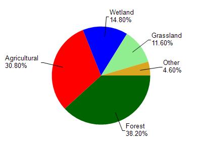
Peppermill Creek is located in the Neenah Creek watershed which is 173.35 mi². Land use in the watershed is primarily forest (38.20%), agricultural (30.80%) and a mix of wetland (14.80%) and other uses (16.20%). This watershed has 198.75 stream miles, 2,104.14 lake acres and 14,499.98 wetland acres.
Nonpoint Source Characteristics
This watershed is ranked Not Available for runoff impacts on streams, Not Ranked for runoff impacts on lakes and High for runoff impacts on groundwater and therefore has an overall rank of High. This value can be used in ranking the watershed or individual waterbodies for grant funding under state and county programs.However, all waters are affected by diffuse pollutant sources regardless of initial water quality. Applications for specific runoff projects under state or county grant programs may be pursued. For more information, go to surface water program grants.