Waushara
No
No
No
Fish and Aquatic Life
Overview
Kusel Lake, in the Pine and Willow Rivers Watershed, is a 73.73 acre lake that falls in Waushara County. This lake is managed for fishing and swimming and is currently considered impaired.
Date 2011
Author Aquatic Biologist
Historical Description
Source: 1970, Surface Water Resources of Waushara County Kusel Lake T-20-N, R-11-E, Sections 26, 27, 34, 35
A moderate-sized, landlocked, seepage lake that exhibits an irregular basin with an elongated shoreline. The lake has three deep water basins, one in the western portion, one in the central portion and one in the eastern portion. For the most part the physiography of the basins in the shallow water areas is characterized by gradual drop-off s. The littoral zone is extensive around the lake and has bottom materials consisting primarily of sand, with minor amounts of muck. A midsummer thermocline develops in the lake at twenty feet. The unbalanced and slow-growing fish population in this lake has posed a management problem. The fishery of the lake includes bluegill, northern pike, largemouth bass, and walleye. Kusel Lake was chemically treated in 1960 to eradicate the entire fish population composed mainly of stunted bluegills, perch, and crappies. Following the rehabilitation, the lake was restocked with northern pike, walleyes, largemouth bass and bluegills. Each year since the 1960 treatment, fish surveys have been conducted on the lake to follow the growth, development and overall condition of the fish population. Although all game fish species planted were successfully established, only the largemouth bass have been successful in producing hatches each year. Since their introduction in 1961, natural reproduction of bluegills has been highly successful. At no time did enough bluegills ever obtain desirable size for the creel. In an attempt to harvest large numbers of stunted bluegills, the lake was partially chemically treated in September of 1967. The results of this partial treatment are still being evaluated. The presence of one resort, 55 cottages, 2 boat liveries, and one private camp on the shoreline is indicative of the popularity of this lake. The campground is private and can accommodate at least 300 units at the present time. Cottage and homesite development is most intensive along the north shore. The southern shoreline is owned by a church camp and is presently undeveloped. The lake receives heavy recreational use primarily for water skiing and swimming during the summer months. There is public access. The township owns approximately 55 acres (approximately 500 feet of frontage) on the east end of the lake that has potential for being developed into a multiple-use area.
Surface Acres = 79; S.D.F. = 1.85; Maximum Depth = 29 feet
Date 1970
Author Surface Water Inventory Of Wisconsin
Impaired Waters
Kusel Lake (189600) was placed on the impaired waters list due to Mercury in fish tissue in 1998. This water is impaired for Fish Consumption use; a special consumption advisory is in effect for Kusel Lake. This water was assessed during the 2016 listing cycle; total phosphorus sample data were clearly below 2016 WisCALM listing thresholds for the Recreation use and Fish and Aquatic Life use. Chlorophyll data did not exceed REC or FAL listing thresholds. This water was also assessed for chlorides and sample data were clearly below 2016 WisCALM chronic and acute listing criteria for the Fish and Aquatic Life use. This water is considered to be meeting both Recreation and Fish and Aquatic Life uses.
Date 2015
Author Ashley Beranek
Condition
Wisconsin has over 84,000 miles of streams, 15,000 lakes and milllions of acres of wetlands. Assessing the condition of this vast amount of water is challenging. The state's water monitoring program uses a media-based, cross-program approach to analyze water condition. An updated monitoring strategy (2015-2020) is now available. Compliance with Clean Water Act fishable, swimmable standards are located in the Executive Summary of Water Condition in 2018. See also the 'monitoring and projects' tab.
Reports
Recommendations
Land Acquisition
Waushara county will acquire approximately 30.78 acres of land with 1,150 feet of shoreline to preserve and protect the shoreline and water quality of Kusel Lake.
Monitor Fish Tissue
Management Goals
Wisconsin's Water Quality Standards provide qualitative and quantitative goals for waters that are protective of Fishable, Swimmable conditions [Learn more]. Waters that do not meet water quality standards are considered impaired and restoration actions are planned and carried out until the water is once again fishable and swimmable
Management goals can include creation or implementation of a Total Maximum Daily Load analysis, a Nine Key Element Plan, or other restoration work, education and outreach and more. If specific recommendations exist for this water, they will be displayed below online.
Monitoring
Monitoring the condition of a river, stream, or lake includes gathering physical, chemical, biological, and habitat data. Comprehensive studies often gather all these parameters in great detail, while lighter assessment events will involve sampling physical, chemical and biological data such as macroinvertebrates. Aquatic macroinvertebrates and fish communities integrate watershed or catchment condition, providing great insight into overall ecosystem health. Chemical and habitat parameters tell researchers more about human induced problems including contaminated runoff, point source dischargers, or habitat issues that foster or limit the potential of aquatic communities to thrive in a given area. Wisconsin's Water Monitoring Strategy was recenty updated.
Grants and Management Projects
Monitoring Projects
| WBIC | Official Waterbody Name | Station ID | Station Name | Earliest Fieldwork Date | Latest Fieldwork Date | View Station | View Data |
|---|
| 189600 | Kusel Lake | 10044894 | Kusel Lake -- [Herbicide Monitoring Site A] | 5/18/2016 | 7/6/2016 | Map | Data |
| 189600 | Kusel Lake | 10007381 | Kusel Lake | 6/1/1993 | 4/11/2022 | Map | Data |
| 189600 | Kusel Lake | 703103 | Kusel Lake - Deep Hole | 5/30/1999 | 3/29/2026 | Map | Data |
| 189600 | Kusel Lake | 10044895 | Kusel Lake -- [Herbicide Monitoring Site C] | 5/18/2016 | 5/25/2016 | Map | Data |
| 189600 | Kusel Lake | 10018799 | Kusel Lake -- Access | 9/30/1963 | 9/26/2018 | Map | Data |
|
Watershed Characteristics
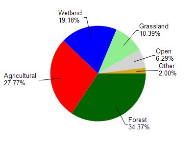
Kusel Lake is located in the Pine and Willow Rivers watershed which is 302.08 mi². Land use in the watershed is primarily forest (34.40%), agricultural (27.80%) and a mix of wetland (19.20%) and other uses (18.70%). This watershed has 377.48 stream miles, 11,273.01 lake acres and 33,136.61 wetland acres.
Nonpoint Source Characteristics
This watershed is ranked High for runoff impacts on streams, Not Ranked for runoff impacts on lakes and High for runoff impacts on groundwater and therefore has an overall rank of High. This value can be used in ranking the watershed or individual waterbodies for grant funding under state and county programs.However, all waters are affected by diffuse pollutant sources regardless of initial water quality. Applications for specific runoff projects under state or county grant programs may be pursued. For more information, go to surface water program grants.