Waushara
No
No
No
Fish and Aquatic Life
Overview
Pine River and Willow Creek are clear, hard water streams that drain the center two-thirds of Waushara County. There are substantial critical animal waste problems in the eastern half of this watershed, though detailed inventories need to be done. Soil erosion, at rates above 2 T/A/YR, combined with local animal waste delivery and in-stream erosion have accelerated deterioration of trophic status of mill ponds on the Pine River and Willow Creek.
The Pine River is a 28-mile-long tributary to the southwest corner of Lake Poygan. Often the river is divided into the Upper Pine (above the Wild Rose Millpond) and the Lower Pine. In the Lower Pine, the Poy Sippi, Pine River, Saxeville, and Idlewild Millponds degrade water quality. Power dams are responsible for fluctuating water levels and surface discharge of warm water. There is some streambank erosion and some agricultural NPS problems.
The Lower Pine River is a highly productive Class I trout stream which originates at the Wild Rose Millpond dam and flows about 23 miles through mostly wooded and light agricultural land before entering Lake Poygan. Streambank erosion and animal waste contribute to the excess vegetation and habitat deterioration. Sewage effluent from the Wild Rose wastewater treatment plant (WWTP) and the Wild Rose Fish Hatchery have caused excessive weed growth problems in the past.
The Upper Pine River consists of the Wild Rose Millpond and the upper reaches of the river. Irrigation from the trout stream area above Poy Sippi for truck farming is a concern. This stretch of the river is not affected by any discharges and would be a good candidate for pristine water and sediment analysis to determine background levels of heavy metals.
Date 1996
Author Cheryl Bougie
Overview
The Pine River is a 28-mile tributary to the southwest comer of Lake Poygan. Often the river
is divided into the Upper Pine (above the Wild Rose Millpond) and the Lower Pine.
In the Lower Pine, the Poy Sippi, Pine River, Saxeville and Idlewild Millponds degrade water
quality. Power dams are responsible for fluctuating water levels and surface discharge of
warm water. Biological, chemical, and physical water quality changes occur following
impoundments creation. Physical changes include the creation of a large pool above the dam
where water flow is reduced, which increases the amount of time water remains in place. The
increase in residence time allows sediment and other solids to settle out and deposit above the
dam. The impoundment water acts as a sediment trap or detention basin. The area above the
dam is often shallow. The combination of nutrient rich sediment deposits and shallow depth
create ideal conditions for the growth of aquatic plants, including algae. This plant material
often becomes a nuisance, limiting recreation. A great deal of time and effort is spent trying
to manage these nuisance plants. The dams also impair the migration of Brown Trout and
Brook Trout during spring and fall runs to prime spawning habitat. Fisheries management has
a strong acquisition program, and fish habitat and maintenance program on the Pine River.
Removal of Saxeville, Poy Sippi and Pine River Dams would improve water quality and fish
migrations to prime spawning habitat. Many of these dams are old and need repair. Fisheries
Management should work with the villages and private dam owners to discuss feasible dam
removal options. There are some streambank erosion and some agricultural polluted runoff
problems.
The Lower Pine River is a highly productive Class I trout stream. It originates at the Wild
Rose Millpond dam and flows about 23 miles through mostly wooded and light agricultural
land before entering Lake Poygan. Streambank erosion and animal waste contribute to excess
vegetation and habitat deterioration. Sewage effluent from the Wild Rose wastewater
treatment plant and the Wild Rose Fish Hatchery have caused excessive weed growth
problems in the past. WDNR Water Resources Management staff should conduct basin
assessment trend stream monitoring on the Pine River to assess long-term water quality trends
in the Wolf River Basin. Parameters that should be monitored in addition to the protocol are
phosphorus and ammonia. This data will then be used to accurately predict impacts and set
effluent limitations for the wastewater treatment plant and the fish hatchery.
The Upper Pine River consists of the Wild Rose Millpond and the upper reaches of the river.
Irrigation for truck farming from the trout stream area above Poy Sippi is a concern. This
stretch of the river is not affected by any discharges and would be a good candidate for
pristine water and sediment analysis to determine background levels of heavy metals.
Date 1996
Author Aquatic Biologist
Management Goals
Wisconsin's Water Quality Standards provide qualitative and quantitative goals for waters that are protective of Fishable, Swimmable conditions [Learn more]. Waters that do not meet water quality standards are considered impaired and restoration actions are planned and carried out until the water is once again fishable and swimmable
Management goals can include creation or implementation of a Total Maximum Daily Load analysis, a Nine Key Element Plan, or other restoration work, education and outreach and more. If specific recommendations exist for this water, they will be displayed below online.
Monitoring
Monitoring the condition of a river, stream, or lake includes gathering physical, chemical, biological, and habitat data. Comprehensive studies often gather all these parameters in great detail, while lighter assessment events will involve sampling physical, chemical and biological data such as macroinvertebrates. Aquatic macroinvertebrates and fish communities integrate watershed or catchment condition, providing great insight into overall ecosystem health. Chemical and habitat parameters tell researchers more about human induced problems including contaminated runoff, point source dischargers, or habitat issues that foster or limit the potential of aquatic communities to thrive in a given area. Wisconsin's Water Monitoring Strategy was recenty updated.
Grants and Management Projects
Monitoring Projects
| WBIC | Official Waterbody Name | Station ID | Station Name | Earliest Fieldwork Date | Latest Fieldwork Date | View Station | View Data |
|---|
| 247800 | Pine River | 10016331 | Lower Pine River at 9th Road | 8/13/1991 | 7/29/2021 | Map | Data |
| 247800 | Pine River | 10032735 | Pine River at Hwy. 49 Poy Sippi | 3/27/2018 | 5/12/2026 | Map | Data |
| 247800 | Pine River | 10050462 | Pine River at Patty Anderson Farm Bridge Downstream of Poy Sippi | 3/27/2018 | 8/4/2021 | Map | Data |
| 247800 | Pine River | 703002 | Pine River - Daisy Dairy Poy Sippi O-F 001 | 12/10/1975 | 3/9/1978 | Map | Data |
|
Watershed Characteristics
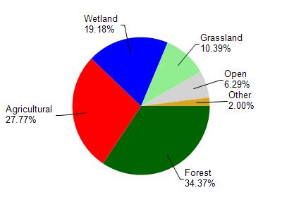
Pine River is located in the Pine and Willow Rivers watershed which is 302.08 mi². Land use in the watershed is primarily forest (34.40%), agricultural (27.80%) and a mix of wetland (19.20%) and other uses (18.70%). This watershed has 377.48 stream miles, 11,273.01 lake acres and 33,136.61 wetland acres.
Nonpoint Source Characteristics
This watershed is ranked High for runoff impacts on streams, Not Ranked for runoff impacts on lakes and High for runoff impacts on groundwater and therefore has an overall rank of High. This value can be used in ranking the watershed or individual waterbodies for grant funding under state and county programs.However, all waters are affected by diffuse pollutant sources regardless of initial water quality. Applications for specific runoff projects under state or county grant programs may be pursued. For more information, go to surface water program grants.