Manitowoc
No
No
No
Fish and Aquatic Life
Overview
CEDAR LAKE
T17N, R21E, Sections 23,24, Manitowoc County, Sheboygan Watershed
Surface acres 139, S.D.F. = 1.97, Maximum depth = 26 feet
Cedar Lake is the largest lake in Manitowoc County, with a maximum depth of 21 feet and an average depth of nine feet. It is a landlocked seepage lake in the terminal moraine of the Lake Michigan glacier. The water is clear, hard and alkaline. The littoral bottom is composed of both gravel and muck. The lake is managed for largemouth bass, pan fish and northern pike. Panfish species include bluegill, crappie and common sunfish. This is the largest lake in Manitowoc County and the shoreline is highly developed. Access is available by two town roads, one of which has parking. About 70% of the 18 acres of adjoining wetland are wooded. Waterfowl make limited use of the lake.
Aquatic Plants
A general survey of the aquatic vegetation was conducted by boat. The aquatic plant community is considered to be moderate although there are some areas that have moderate to dense growth of submergents. The aquatic plant community is considered to be moderately diverse with a mixture of tolerant to intolerant species. Bulrushes are present in a limited number of areas, as are both yellow and White Water Lilies. The submergent community includes a variety of pondweeds (Potamogeton sp.), Eel Grass (Valisneria sp.), Najas sp., Water Buttercup (Ranunculus sp.), and Muskgrass (Chara sp.). Table 42 summarizes the species observed during the survey.
Table 32. Aquatic Plants in Cedar Lake, Manitowoc County
Common Name Scientific Name
Pondweed
Flatstemmed Pondweed
Largeleaf Pondweed
Robinson Pondweed
Sago Pondweed
Eel Grass
Bushy Pondweed
Water Buttercup
Bulrush
Sedges
Yellow Water Lily
White Water Lily
Musk Grass Potamogeton sp.
Potamogeton zosterformis
Potamogeton amplifolius
Potamogeton robinsii
Potamogeton pectinatus
Valisneria sp.
Najas sp.
Rannunculus sp.
Juncus sp.
Eleocharis sp.
Nuphar sp.
Nymphaea sp.
Chara sp.
Water Quality
The water quality of Cedar Lake was monitored on May 4 and August 24, 1994. Temperature, dissolved oxygen, specific conductance, pH, and total dissolved solids were measured in the water column. The temperature profiles showed only a slight temperature difference from top to bottom in May and August (Wakeman 1996). The dissolved oxygen profile is slightly more stratified in August than in May however the bottom water had a concentration of 4.2 ppm. The lack of any strong stratification during the summer and the aerobic conditions in the bottom waters will minimize the internal phosphorus load to the lake. The water clarity of Cedar Lake on May 4, 1994 was excellent, the secchi disk could be seen on the bottom in 6.5 meters (20 ft) of water. On August 24, 1994 the water clarity was still very good with a secchi disk reading of 3.5 meters (11.5 ft) (Wakeman 1996).
Trophic Status Index
The Trophic Status Index of Cedar Lake was calculated based upon the existing water quality data. The trophic status index for Cedar Lake is considered to be mesotrophic. A slight downward trend can be observed (Figure 12), however additional monitoring needs to be conducted to determine the significance of this trend.
Date 2001
Author Aquatic Biologist
Historical Description
Source: 1968, Surface Water Resources of Manitowoc County Cedar Lake, T17N, R21E, Sections 23,24 Surface acres - 139, S.D.F. = 1.97, Maximum depth = 26 feet.
A landlocked seepage lake in the terminal moraine of the Lake Michigan glacier. The water is clear, hard and alkaline. The littoral bottom is composed of both ravel and muck. The lake is managed for largemouth bass, pang fish and northern pike. Panfish species include bluegill, crappie and common sunfish. This is the largest lake in Manitowoc County and has a high development of shoreline for cottages, including one resort, a Boy Scout camp, and two boat rental facilities. Access is available by two town roads, one of which has parking. A county owned access is in the planning stage. About 70% of the 18 acres of adjoining wetland are wooded. Waterfowl make limited use of the lake and hunting is permitted.
Date 1968
Author Surface Water Inventory Of Wisconsin
Management Goals
Wisconsin's Water Quality Standards provide qualitative and quantitative goals for waters that are protective of Fishable, Swimmable conditions [Learn more]. Waters that do not meet water quality standards are considered impaired and restoration actions are planned and carried out until the water is once again fishable and swimmable
Management goals can include creation or implementation of a Total Maximum Daily Load analysis, a Nine Key Element Plan, or other restoration work, education and outreach and more. If specific recommendations exist for this water, they will be displayed below online.
Monitoring
Monitoring the condition of a river, stream, or lake includes gathering physical, chemical, biological, and habitat data. Comprehensive studies often gather all these parameters in great detail, while lighter assessment events will involve sampling physical, chemical and biological data such as macroinvertebrates. Aquatic macroinvertebrates and fish communities integrate watershed or catchment condition, providing great insight into overall ecosystem health. Chemical and habitat parameters tell researchers more about human induced problems including contaminated runoff, point source dischargers, or habitat issues that foster or limit the potential of aquatic communities to thrive in a given area. Wisconsin's Water Monitoring Strategy was recenty updated.
Grants and Management Projects
Monitoring Projects
| WBIC | Official Waterbody Name | Station ID | Station Name | Earliest Fieldwork Date | Latest Fieldwork Date | View Station | View Data |
|---|
| 45100 | Cedar Lake | 363287 | Cedar Lake - Deep Hole | | | Map | Data |
| 45100 | Cedar Lake | 363120 | Cedar Lake - Deep Hole | 7/26/1973 | 7/17/2024 | Map | Data |
| 45100 | Cedar Lake | 10051978 | Cedar Lake - SE Bay | 10/10/2005 | 6/23/2026 | Map | Data |
| 45100 | Cedar Lake | 10003523 | Cedar Lake | 4/19/1971 | 11/30/2025 | Map | Data |
| 45100 | Cedar Lake | 10019218 | Cedar Lake -- Access Nr Split Rail Rd | 6/21/2003 | 5/31/2026 | Map | Data |
| 45100 | Cedar Lake | 10059963 | Cedar Lake - Herbicide Monitoring Site C | 5/27/2025 | 7/22/2025 | Map | Data |
| 45100 | Cedar Lake | 10059962 | Cedar Lake - Herbicide Monitoring Site B | 5/27/2025 | 7/22/2025 | Map | Data |
| 45100 | Cedar Lake | 10038941 | Cedar Lake - Camp Rokilio Beach | 5/21/2001 | 5/29/2007 | Map | Data |
|
Watershed Characteristics
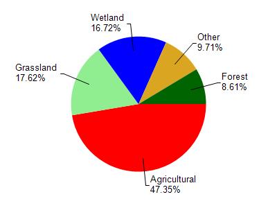
Cedar Lake is located in the Sheboygan River watershed which is 260.12 mi². Land use in the watershed is primarily agricultural (47.30%), grassland (17.60%) and a mix of wetland (16.70%) and other uses (18.30%). This watershed has 340.24 stream miles, 4,345.33 lake acres and 27,968.05 wetland acres.
Nonpoint Source Characteristics
This watershed is ranked Not Available for runoff impacts on streams, Not Available for runoff impacts on lakes and High for runoff impacts on groundwater and therefore has an overall rank of High. This value can be used in ranking the watershed or individual waterbodies for grant funding under state and county programs.However, all waters are affected by diffuse pollutant sources regardless of initial water quality. Applications for specific runoff projects under state or county grant programs may be pursued. For more information, go to surface water program grants.