")
37.63 Miles
50 - 87.63
Warm Mainstem, Macroinvertebrate, Warm Headwater, COOL-Warm Mainstem, COOL-Warm Headwater
2026
Poor
Elevated Water Temperature, Degraded Habitat
Total Phosphorus, Sediment/Total Suspended Solids, Unknown Pollutant
Dodge, Fond Du Lac
No
No
Yes
Fish and Aquatic Life
Overview
The West Branch of the Rock River has its headwaters east of the Village of Brandon. It flows east and then south through mainly agricultural land. This area contains many drained wetlands, so there is likely a relatively high input of groundwater from drain tile. This river is only partially supporting its potential as a warmwater sport fishery. Observations and monitoring of the river reveal extensive sedimentation (WDNR, 1994). The West Branch is the principle source of runoff, nutrient and sediment loading to the Horicon National Wildlife Refuge (Rock River Partnership Monitoring Study, 1999). Baseline monitoring was conducted in 2000. Initial evaluation indicates the river is in fair condition.
Date 2002
Author Aquatic Biologist
General Condition
Willow and Ladoga Creeks flow into the river from the west as the river flows south. There are no Surface Water Integrated Monitoring System (SWIMS) monitoring stations in this stretch; therefore, there is no water quality data available until the river intersects Highway 151 in the Town of Waupun (T-14-N; R-15-E, Sect 24, SWIMS station # 143258). Data from this station is limited legacy data from the winter of 1975-76. The next SWIMS station is approximately 500 feet south on Guenther Road (SWIMS station # 203105). There is an extensive amount of water quality data for this station dating from late 1997-2000.
The next SWIMS station is approximately two miles downstream at Oak Center Road. SWIMS lists four stations for this crossing. Two of the stations ( 203126 and 100000) have no data available in SWIMS. Station # 203129 has very limited water quality data but two Hilsenhoff Biotic Index (HBI) surveys have been conducted showing a HBI of 6.56 (fairly poor) in 2000 and 5.54 (fair) in 2008. In 2000, fish and habitat surveys were conducted at Oak Center Road (station 10008399) showing an Index of Biotic Integrity (IBI) of 15 (very poor) and a Qualitative Habitat Rating of 40 (fair). The next monitoring downstream is approximately 1 mile southof the junction with the South Branch Rock River. The entire west Branch Rock River has been listed as an impaired water due to sedimentation, habitat degradation and excessive nutrients. Although the river has never been formally classified, it is a default warm water sport fishery, which would likely be the correct classification.
Date 2011
Author Aquatic Biologist
Impaired Waters
The 2018 assessments of the West Branch Rock River (miles 50-87.63) showed impairment by phosphorus and temperature; new total phosphorus sample data overwhelmingly exceeded and new temperature sample exceeded the 2018 WisCALM listing criteria for the Fish and Aquatic Life use. However, available biological data did not indicate impairment (i.e. no macroinvertebrate or fish Index of Biotic Integrity (IBI) scored in the "poor" condition category). Based on the most updated information, no change in the existing impaired waters listing was needed.
Date 2017
Author Ashley Beranek
Condition
Wisconsin has over 84,000 miles of streams, 15,000 lakes and milllions of acres of wetlands. Assessing the condition of this vast amount of water is challenging. The state's water monitoring program uses a media-based, cross-program approach to analyze water condition. An updated monitoring strategy (2015-2020) is now available. Compliance with Clean Water Act fishable, swimmable standards are located in the Executive Summary of Water Condition in 2018. See also the 'monitoring and projects' tab.
Reports
Recommendations
Monitor Water Quality or Sediment
Would like more than 3 months of data on this site to list for TEMP. Possible to get one more field season for additional [data]. AU: 11566; ID: 10044757
Navigability Determination
14N 15E S34; West Branch Rock River; extension of previous determination
Navigability Determination
T15N R14E ; West Branch Rock River;
Monitor Targeted Area
Work with the US Fish and Wildlife to assess the impacts of poor water quality on the Horicon marsh system.
Management Goals
Wisconsin's Water Quality Standards provide qualitative and quantitative goals for waters that are protective of Fishable, Swimmable conditions [Learn more]. Waters that do not meet water quality standards are considered impaired and restoration actions are planned and carried out until the water is once again fishable and swimmable
Management goals can include creation or implementation of a Total Maximum Daily Load analysis, a Nine Key Element Plan, or other restoration work, education and outreach and more. If specific recommendations exist for this water, they will be displayed below online.
Monitoring
Monitoring the condition of a river, stream, or lake includes gathering physical, chemical, biological, and habitat data. Comprehensive studies often gather all these parameters in great detail, while lighter assessment events will involve sampling physical, chemical and biological data such as macroinvertebrates. Aquatic macroinvertebrates and fish communities integrate watershed or catchment condition, providing great insight into overall ecosystem health. Chemical and habitat parameters tell researchers more about human induced problems including contaminated runoff, point source dischargers, or habitat issues that foster or limit the potential of aquatic communities to thrive in a given area. Wisconsin's Water Monitoring Strategy was recenty updated.
Grants and Management Projects
Monitoring Projects
| WBIC | Official Waterbody Name | Station ID | Station Name | Earliest Fieldwork Date | Latest Fieldwork Date | View Station | View Data |
|---|
| 861300 | West Branch Rock River | 143020 | Horicon Marsh at Stroak'S Ditch H Mar | 2/26/1990 | 7/18/2023 | Map | Data |
| 5591081 | Unnamed | 10041891 | Unnamed Lake (WBIC 5591081) | 7/4/2011 | 9/30/2017 | Map | Data |
| 861300 | West Branch Rock River | 143019 | Horicon Marsh at Federal Dike | 11/18/1975 | 2/26/1990 | Map | Data |
| 861300 | West Branch Rock River | 10034786 | West Branch Rock River - Dixon Rd. crossing | | | Map | Data |
| 861300 | West Branch Rock River | 10039911 | West Branch Rock River at Hwy M | 5/10/2013 | 1/1/2015 | Map | Data |
| 861300 | West Branch Rock River | 10042247 | Main Ditch spillway_West Branch Rock River | 6/5/2014 | 9/17/2019 | Map | Data |
| 5567346 | Unnamed | 101073 | Unnamed - WBIC 5567346 | 8/28/2008 | 9/30/2017 | Map | Data |
| 861300 | West Branch Rock River | 10036353 | West Branch Rock River - Area of Open Water | | | Map | Data |
| 861300 | West Branch Rock River | 10034785 | West Branch Rock River - Church Rd. crossing | | | Map | Data |
| 861300 | West Branch Rock River | 10022927 | West Branch Rock River - Pier At End Of Dike Rd. | 4/29/2008 | 8/6/2025 | Map | Data |
| 861300 | West Branch Rock River | 10044757 | West Branch Rock River at Neitman Road | 4/12/2011 | 7/15/2026 | Map | Data |
| 861300 | West Branch Rock River | 100000 | Rock River West Br - Above S Br Banner Rd | 9/6/2000 | 9/6/2000 | Map | Data |
| 861300 | West Branch Rock River | 143263 | Rock River West Branch at Sth 49 | 11/18/1975 | 10/17/2023 | Map | Data |
| 861300 | West Branch Rock River | 203129 | Rock River West Branch - On Oak Center Rd. (Banner) | 11/2/2000 | 8/6/2025 | Map | Data |
| 861300 | West Branch Rock River | 203105 | West Branch Rock River - Near Waupun WI | 11/19/1997 | 12/12/2000 | Map | Data |
| 861300 | West Branch Rock River | 10036825 | West Branch Rock River - Area of Open Water | | | Map | Data |
| 861300 | West Branch Rock River | 145013 | Rock River - West Branch - Waupun Below Highway 49 | | | Map | Data |
| 861300 | West Branch Rock River | 143257 | Rock River West Branch at Federal Dike | | | Map | Data |
| 861300 | West Branch Rock River | 10008399 | West Branch Rock River At Oak Center Rd. | 6/13/2000 | 11/2/2000 | Map | Data |
| 861300 | West Branch Rock River | 10034783 | West Branch Rock River- Hwy 26 crossing | 5/22/2002 | 1/1/2015 | Map | Data |
| 861300 | West Branch Rock River | 10039912 | West Branch Rock River at Hwy TC | 5/10/2013 | 1/1/2015 | Map | Data |
| 861300 | West Branch Rock River | 143264 | Rock River West Branch - So Dike | | | Map | Data |
| 5566074 | Unnamed | 100992 | Unnamed - WBIC 5566074 | 8/28/2008 | 9/30/2017 | Map | Data |
| 861300 | West Branch Rock River | 10037824 | West Branch Rock River - Peachy Road | 10/17/2023 | 10/17/2023 | Map | Data |
| 861300 | West Branch Rock River | 10039910 | West Branch Rock River at Metovale Rd. | 5/10/2013 | 8/22/2017 | Map | Data |
| 861300 | West Branch Rock River | 203126 | Rock River West Branch - Above S Br Confluence | | | Map | Data |
| 861300 | West Branch Rock River | 10047918 | West Br Rock River-inside carp trap | | | Map | Data |
| 861300 | West Branch Rock River | 10035407 | West Branch Rock River - Area of Open Water | | | Map | Data |
| 861300 | West Branch Rock River | 143258 | Rock River West Branch at Sth 151 | 11/18/1975 | 2/19/1976 | Map | Data |
| 861300 | West Branch Rock River | 203131 | West Branch Rock River at Sth 49 Near Waupun WI | 8/4/1998 | 9/17/2019 | Map | Data |
| 861300 | West Branch Rock River | 10036325 | West Branch Rock River - Area of Open Water | | | Map | Data |
| 861300 | West Branch Rock River | 10036409 | West Branch Rock River - Area of Open Water | | | Map | Data |
|
Watershed Characteristics
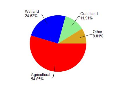
West Branch Rock River is located in the Upper Rock River watershed which is 257.61 mi². Land use in the watershed is primarily agricultural (54.60%), wetland (24.60%) and a mix of grassland (11.90%) and other uses (8.80%). This watershed has 335.43 stream miles, 1,629.48 lake acres and 40,442.61 wetland acres.
Nonpoint Source Characteristics
This watershed is ranked Medium for runoff impacts on streams, High for runoff impacts on lakes and High for runoff impacts on groundwater and therefore has an overall rank of High. This value can be used in ranking the watershed or individual waterbodies for grant funding under state and county programs.However, all waters are affected by diffuse pollutant sources regardless of initial water quality. Applications for specific runoff projects under state or county grant programs may be pursued. For more information, go to surface water program grants.
Rock River, West Branch is considered a Warm Mainstem, Macroinvertebrate, Warm Headwater, COOL-Warm Mainstem, COOL-Warm Headwater under the state's Natural Community Determinations.
Natural communities (stream and lake natural communities) represent model results and DNR staff valiation processes that confirm or update predicted conditions based on flow and temperature modeling from historic and current landscape features and related variables. Predicated flow and temperatures for waters are associated predicated fish assemblages (communities). Biologists evaluate the model results against current survey data to determine if the modeled results are corect and whether biological indicators show water quaity degradation. This analysis is a core component of the state's resource management framework. Wisconsin's Riverine Natural Communities.
Cool (Warm-Transition) Headwaters are small, sometimes intermittent streams with cool to warm summer temperatures. Coldwater fishes are uncommon to absent, transitional fishes are abundant to common, and warm water fishes are common to uncommon. Headwater species are abundant to common, mainstem species are common to absent, and river species are absent.
Warm Mainstem waters are moderate-to-large but still wadeable perennial streams with relatively warm summer temperatures. Coldwater fishes are absent, transitional fishes are common to uncommon, and warm water fishes are abundant to common. Headwater species are common to absent, mainstem species are abundant to common, and river species are common to absent.
Warm Headwaters are small, usually intermittent streams with warm summer temperatures. Coldwater fishes are absent, transitional fishes are common to uncommon, and warm water fishes are abundant to common. Headwater species are abundant to common, mainstem species are common to absent, and
river species are absent.