Rock
No
Yes
No
Fish and Aquatic Life
Overview
Rock River Water Quality Management Plan, Lower Rock River Appendix. WT-668-2002. South Central Region, WDNR.
Little Turtle Creek Most of Little Turtle Creek's 12 miles have been ditched for drainage of the surrounding farm lands, resulting in habitat deterioration, increased water temperatures, high turbidity, sedimentation, infilling of deep pool habitat, and excessive nutrient and fecal bacteria concentrations.
This stream is managed as a warm water forage fishery. The Rock County portion of this stream is an Exceptional Resource Water. The stream supports the gravel chub and slender madtom, two species on the state threatened and endangered species list. Little Turtle Creek is too shallow to provide habitat for game fish.
Date 2002
Author Aquatic Biologist
Overview
Rock River Water Quality Management Plan, Lower Rock River Appendix. WT-668-2002. South Central Region, WDNR.
Turtle Creek--Rock-Walworth Co. Line to the WI/IL Border This 20-mile segment runs from the Rock-Walworth county line southwest to where it empties into the Rock River at Beloit. A high quality resource, it is designated an Exceptional Resource Water. This segment has a higher gradient than the first two segments, but it is still affected by urban polluted runoff in the Beloit area and by sediment from adjacent corn fields and severely eroding streambanks upstream of the city.
The Shopiere Dam was removed in 2000. Walleye, catfish, northern pike, and panfish now have access to the upper reaches of the stream. Formerly, Turtle Creek supported an excellent smallmouth bass fishery below the dam and a marginal smallmouth bass fishery above the dam. The removal of the Shopiere Dam has enabled fish migration and the smallmouth bass fishery is expected to improve.
Date 2002
Author Aquatic Biologist
Historical Description
A warm water stream originating in southwest Walworth County, flowing into Rock County and then north. The stream swings back east into Walworth County were it meanders north again and then flows back into Rock County for a short distance before reaching Turtle Creek. The stream is managed for forage species but a few smallmouth bass may enter from Turtle Creek. Most of the stream in Rock County has been ditched resulting in habitat deterioration and elevated water temperatures. Adjoining fresh meadow wetland totals 22 acres. The mouth of the stream lies in the Turtle Creek Wildlife area. Access is available from 2 town roads and 3 county road crossings, and from Turtle Creek.
Surface Acres = 24.44 Miles= 7.2, Gradient = 8.25 feet per mile.
From: Ball, Joseph R., and Ronald J. Poff, Lake and Stream Classification Project. Surface Water Resources of Rock County, Department of Natural Resources, 1970.
Date 1970
Author Aquatic Biologist
Impaired Waters
The 2018 assessments of Little Turtle Creek (Rock-Walworth county line south of Lake Shore Road to Rock-Walworth county line north of HWY 43) showed impairment by phosphorus; new total phosphorus sample data exceeded the 2018 WisCALM listing criteria for the Fish and Aquatic Life use. However, available biological data did not indicate impairment (i.e. no macroinvertebrate or fish Index of Biotic Integrity (IBI) scored in the "poor" condition category). Based on the most updated information, this water was proposed for the impaired waters list.
Date 2017
Author Ashley Beranek
Condition
Wisconsin has over 84,000 miles of streams, 15,000 lakes and milllions of acres of wetlands. Assessing the condition of this vast amount of water is challenging. The state's water monitoring program uses a media-based, cross-program approach to analyze water condition. An updated monitoring strategy (2015-2020) is now available. Compliance with Clean Water Act fishable, swimmable standards are located in the Executive Summary of Water Condition in 2018. See also the 'monitoring and projects' tab.
Reports
Management Goals
Wisconsin's Water Quality Standards provide qualitative and quantitative goals for waters that are protective of Fishable, Swimmable conditions [Learn more]. Waters that do not meet water quality standards are considered impaired and restoration actions are planned and carried out until the water is once again fishable and swimmable
Management goals can include creation or implementation of a Total Maximum Daily Load analysis, a Nine Key Element Plan, or other restoration work, education and outreach and more. If specific recommendations exist for this water, they will be displayed below online.
Monitoring
Monitoring the condition of a river, stream, or lake includes gathering physical, chemical, biological, and habitat data. Comprehensive studies often gather all these parameters in great detail, while lighter assessment events will involve sampling physical, chemical and biological data such as macroinvertebrates. Aquatic macroinvertebrates and fish communities integrate watershed or catchment condition, providing great insight into overall ecosystem health. Chemical and habitat parameters tell researchers more about human induced problems including contaminated runoff, point source dischargers, or habitat issues that foster or limit the potential of aquatic communities to thrive in a given area. Wisconsin's Water Monitoring Strategy was recenty updated.
Grants and Management Projects
| Project Name (Click for Details) | Year Started |
|---|
|
|
Monitoring Projects
| WBIC | Official Waterbody Name | Station ID | Station Name | Earliest Fieldwork Date | Latest Fieldwork Date | View Station | View Data |
|---|
|
|
Watershed Characteristics
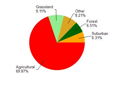
Little Turtle Creek is located in the Turtle Creek watershed which is 288.47 mi². Land use in the watershed is primarily agricultural (69.80%), grassland (9.10%) and a mix of forest (6.50%) and other uses (14.50%). This watershed has 339.80 stream miles, 590.58 lake acres and 6,590.97 wetland acres.
Nonpoint Source Characteristics
This watershed is ranked Not Available for runoff impacts on streams, Not Available for runoff impacts on lakes and High for runoff impacts on groundwater and therefore has an overall rank of High. This value can be used in ranking the watershed or individual waterbodies for grant funding under state and county programs.However, all waters are affected by diffuse pollutant sources regardless of initial water quality. Applications for specific runoff projects under state or county grant programs may be pursued. For more information, go to surface water program grants.