Rock
No
No
Yes
Fish and Aquatic Life
Overview
Stevens Creek is a small warm water stream tributary to Bass Creek near Hanover. The stream is very turbid and its flow sluggish in its lower reaches. While flow above State Highway 11 is much stronger, obvious erosion from agricultural cropland and pasture use affects the stream's water quality. The fishery consists of forage fish although fisheries managers believe the stream could sustain a trout fishery if protected. Like Bass Creek, the water quality of Stevens Creek is affected by cropland erosion, barnyard runoff, and streambank erosion. A May 1996 habitat evaluation characterized the stream's habitat at the Mineral Point Road crossing as poor. Twenty cattle were observed standing in the stream. The stream's habitat at the Snyder Road crossing was also considered poor. The entire 8-mile length of Stevens Creek is on the 303(d) list of impaired waters.
Date 2002
Author Aquatic Biologist
Historical Description
A seepage-fed warm water stream rising north of Footville, then flowing south to enter Bass Creek at Hanover. The fishery is composed of forage species only. Adjoining fresh meadow wetland totals 655 acres and supports a fair pheasant population. Access is available from two town roads, two country roads and one state highway crossing.
Surface Acres -5.33, Miles = 5.5, Gradient = 14.5 feet per mile.
From: Ball, Joseph R., and Ronald J. Poff, Lake and Stream Classification Project. Surface Water Resources of Rock County, Department of Natural Resources, 1970.
Date 1970
Author Aquatic Biologist
Condition
Wisconsin has over 84,000 miles of streams, 15,000 lakes and milllions of acres of wetlands. Assessing the condition of this vast amount of water is challenging. The state's water monitoring program uses a media-based, cross-program approach to analyze water condition. An updated monitoring strategy (2015-2020) is now available. Compliance with Clean Water Act fishable, swimmable standards are located in the Executive Summary of Water Condition in 2018. See also the 'monitoring and projects' tab.
Reports
Recommendations
Citizen-Based Stream Monitoring
Collect chemical, physical, and/or biological water quality data to assess the current overall stream health. The data can inform management decisions and may be used to identify impaired waters for biennial lists.
Restore Wetlands
Restore Wetlands
Runoff Grant
The Rock County LCD may also apply for a Targeted Runoff Management (TRM) grant through WDNR. TRM grants are competitive financial awards to support small-scale, short term projects (24 months) completed by governmental units to reduce runoff pollution. Both urban and agricultural projects can be funded through a TRM grant; however, the grants require a local contribution to the project. The state share is capped at $150,000.
Cost-Share Agreement
The Environmental Quality Incentive Program (EQIP) is another option available to landowners. EQIP is a fedcost-share program administered by the Natural Resources Conservation Service (NRCS) that provides
farmers with technical and financial assistance. Farmers may receive up to seventy five percent reimbursement
for installing and implementing runoff management practices. Eligible projects can include: terraces, waterways, diversions, and contour strips to manage agricultural waste, promote stream buffers, and control erosion on agricultural lands.
Master Planning
Farmers may enroll in the Conservation Reserve Enhancement Program (CREP) or similar programs to establish
vegetated buffers on cropland and marginal pastures. Riparian buffers assist in making CREP a viable program
for this impaired stream. A similar program available is the Conservation Reserve Program (CRP), which takes
highly erodible land out of agricultural use. As of May 2005, 394 acres in the Markham Creek and Stevens Creek
watersheds were enrolled in CRP and CREP. Of the 394 enrolled acres, 118 acres are within 20 feet of a stream
or major drainage way. Of these, 82 acres are filter strips and the other 36 acres are enrolled as wetland restorations or scrape ponds for wildlife.
TMDL Implementation
To reach the TMDLs in the Stevens Creek and Markham Creek watersheds best management practices such as
riparian buffers and conservation tillage are encouraged in agricultural land use settings to reduce loading during high flow events. In addition to the implementation of enforceable non-point source performance standards, there are a number of voluntary programs that will assist in implementing these TMDLs.
Management Goals
Wisconsin's Water Quality Standards provide qualitative and quantitative goals for waters that are protective of Fishable, Swimmable conditions [Learn more]. Waters that do not meet water quality standards are considered impaired and restoration actions are planned and carried out until the water is once again fishable and swimmable
Management goals can include creation or implementation of a Total Maximum Daily Load analysis, a Nine Key Element Plan, or other restoration work, education and outreach and more. If specific recommendations exist for this water, they will be displayed below online.
Monitoring
Monitoring the condition of a river, stream, or lake includes gathering physical, chemical, biological, and habitat data. Comprehensive studies often gather all these parameters in great detail, while lighter assessment events will involve sampling physical, chemical and biological data such as macroinvertebrates. Aquatic macroinvertebrates and fish communities integrate watershed or catchment condition, providing great insight into overall ecosystem health. Chemical and habitat parameters tell researchers more about human induced problems including contaminated runoff, point source dischargers, or habitat issues that foster or limit the potential of aquatic communities to thrive in a given area. Wisconsin's Water Monitoring Strategy was recenty updated.
Grants and Management Projects
Monitoring Projects
| WBIC | Official Waterbody Name | Station ID | Station Name | Earliest Fieldwork Date | Latest Fieldwork Date | View Station | View Data |
|---|
| 796300 | Stevens Creek | 10015866 | Stevens Creek - 3 - Mineral Pt. Rd. Crossing | 7/1/1992 | 6/27/2000 | Map | Data |
| 796300 | Stevens Creek | 543264 | Stevens Creek - Hanover Rd | 8/27/1998 | 1/13/2026 | Map | Data |
| 796300 | Stevens Creek | 10010928 | Stevens Creek at Footville-Hanover | 5/16/1997 | 1/1/2015 | Map | Data |
| 796300 | Stevens Creek | 10014418 | Stevens Creek-200m Ds Footville Hanover Rd | | | Map | Data |
| 796300 | Stevens Creek | 10012064 | Stevens Creek - Upstream Of Sth 11 | 6/27/2000 | 1/1/2015 | Map | Data |
| 796300 | Stevens Creek | 543276 | Stevens Creek - Snyder Road | 5/16/1997 | 10/4/2005 | Map | Data |
| 796300 | Stevens Creek | 10010927 | Stevens Creek - Steves Creek At Snyder Rd | 1/3/2000 | 11/1/2000 | Map | Data |
| 796300 | Stevens Creek | 543278 | Stevens Creek - Footville Road | 6/27/2000 | 8/4/2005 | Map | Data |
|
Watershed Characteristics
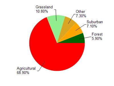
Stevens Creek is located in the Bass Creek watershed which is 113.10 mi². Land use in the watershed is primarily agricultural (68.90%), grassland (10.80%) and a mix of suburban (7.10%) and other uses (13.20%). This watershed has 210.28 stream miles, 79.27 lake acres and 2,685.49 wetland acres.
Nonpoint Source Characteristics
This watershed is ranked High for runoff impacts on streams, Not Ranked for runoff impacts on lakes and High for runoff impacts on groundwater and therefore has an overall rank of High. This value can be used in ranking the watershed or individual waterbodies for grant funding under state and county programs.However, all waters are affected by diffuse pollutant sources regardless of initial water quality. Applications for specific runoff projects under state or county grant programs may be pursued. For more information, go to surface water program grants.